After being totally inspired by this post I had my first go at bikepacking this weekend. Sorry about the pic quality.
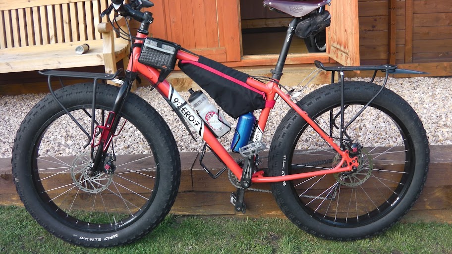
My bike:

3/4 thermarest and old single-hoop goretex bivvy bag on the bars, either side of cables and held in place with two straps. Map on top of this under rubber bands. Spare clothes stuffed in with bivvy bag.

Top-tube bag with energy bars and phone.
1.3kg down sleeping bag behind the saddle, in a stuff sack from a synthetic Decathlon bag – this bag has compression straps built in which makes it easy to attach. Small saddle pack attached below the sleeping bag with multitool, spare tube and levers.
Two bottles with 750ml of plain water in each. I considered getting a cheap triangle frame bag to replace one bottle, but the 35°C heat meant that I needed a LOT of liquid.
Camelbak Mule with 2.5l of isostar, food pump and other tools.
I usually run a fast XC tyre on the back (Specialized Fast Trak or an old Michelin XCR Dry2) but a fully loaded test ride saw me put a big hole in a Michelin so I went with a Specialized Captain control front and back, pumped up a bit more than usual.
It was moderately epic. I thought that two 70km days would be reasonable, so I planned to do this:
http://www.gpsies.com/map.do?fileId=jzjhauqdbnqjettu The route was chosen to take loads of fireroads. Most of the first day follows the “Grand Traversee de l’Herault” or GT34 – a bike/horse/foot trail that goes from near Montpellier to almost Carcassonne. After that I planned to go up fireroafd to the summit of Roc Blanc and bivvy up there, then the second day was to traverse the long line of La Seranne to Mont St Baudille, take a rather spicy descent and come back via fireroads and a GR footpath that uses an old rail track for most of it’s length (GR653).
First day up to the summit of Roc Blanc went really well. No bike problems, but the final long, long fireroad climb really meant I had to dig deep (and keep stopping – amazing the difference a few extra kilos make!).
Near the start, looking at Hortus and Pic St Loup:

First view of the days objective – Roc Blanc:

From near the top of Roc Blanc looking at Pic St Loup from the other side:

From the top of Roc Blanc I had the first surprise. The ridge path was exactly that: a path along a ridge. The end of the fireroad was just a carpark, and exposed to the wind so I started climbing down the path, to see if I could get to the end of the rocky section before bivvying. Not far along I found a lovely flat platform sheltered from the wind:

I slept well. Day2 did not go as planned. The ridge path became a tiny, unrideable path through dense spiky vegetation over rocks. I lost the path, clambered through bushes then found it again and descended down to what looks like a big right turn on the map, I think. All that took about an hour.
But sometime during that hour I’d managed to loose my map…
I tried to follow trails from memory, but I got really badly lost. What looks like a long obvious ridgeline on the map is really quite flat on top, with a myriad of hunters/animal tracks that seem to be good then just stop in the middle of bushes. I got cut to ribbons whilst sturggling through dry spiky vegetation with a fully loaded bike balanced across my shoulders.
After a couple more hours of very slow progress I spotted a path heading down the hillside to the valley below, near St Jean de Bueges (the village in this picture):

Fortunately I found it, and escaped downwards, dropping about 600m in about 20mins. This picture shows one of the sections between terrifying crumbling hairpins:

After lunch in a cafe:

I followed the road parallel to the ridge. No way did I have the reserves to go back up to the top of Mt St Baudille and do the descent, but I picked up my original planned route and went to St Jean de Fos by fireroad:

No more pictures after this, as I managed to loose my phone SOMEWHERE on the long descent down… This meant that I was absolutely ragged, still about 35km from home and with no backup.
Fortunately an old lady out for a run (!) found it and handed it in at a local Town Hall, where I picked it up the next day. How lucky!!
I did Aniane to La Boissiere on the GR653 – rocky but mostly flat old railway, then I dropped my plan and used the road to head home.
A very interesting experience.