IIRC the checkpoints are released tomorrow. Anyone else getting a little excited about it?
😀
Yep looking forward to it
Yep.
Our little gang of 8 [b]might[/b] have 3 bailers on it.
I've emailed Stuart to ask if he has a reserve list to contact.
I'm looking forward to it and I'm not even going 😉
Had your email John and will reply ... hoping to get the grid references out today sometime. If you're on the list and haven't had them by Sunday check your spam folder.
Cheers
Stuart
Route sorted 120 miles and 20,000 feet of ups and downs.
I don't think I'll be single speeding this one
Yeah my first cut has come in at 126 miles, haven't done the ascent descent yet, not sure I want to.
130 miles for me. 300 feet less elevation though
You lot are quick ... do those routes include all 13 grid references or 11?
Stuart
11 for me, about an extra 6 to pick up a 12th, but that appears to include a walk across featureless moorland (on a 6 year old copy of MM @ 1:50000...)
all 13 logged for me
13 logged here as well.
As it's not a race I'll let you into one of my secrets.
This site should help everyone in the planning stages
Ok, 131.5 miles, all 13.... it had better not rain again till June.
Thanks for the link John
Just had a look at that link John ... that's my road and field that is, however the bluebells might not be 😀
Stuart
just shaved off about 4 miles with that link, cheers john.
Yea that'll make all the difference 😉
I'm really looking forward to this now but my first stab is coming in at way more than 130 miles. Hmmm, more work to do.
How are you plotting your routes and navigating during the event? Paper maps or computer and GPS?
How are you plotting your routes and navigating during the event? Paper maps or computer and GPS?
gps and paper maps out with me, PC left at home 😉
I'm using a helicopter 😛 Just had my first look at the layout having been in France at the weekend, it looks a stunner. Doithe valley, watersplashes down the Teifi, Monks Trod, looks like water wings will be the order of the day.
Flipflops or Crocs could be well worthwhile ... won't weigh much and might just save wet feet.
I know a few of the trails from previous exploits. Including multiple thigh deep river crossings after the biblical floods in September 2008, finding the land rover involved in [url= http://news.bbc.co.uk/1/hi/wales/8348273.stm ]this accident[/url] in the dark after an epic day was a bit eery.
Just hoping for better weather this time.
The Doethie valley is just awesome!
Yea that'll make all the difference
4 miles could make all the difference.
Your not even doing it, so button it! 😆
*Sorry you're right, that 3% reduction in distance could be a real lifesaver 😀 ... and someone has to stay behind and man the tipee. It's too big a construction to leave on its own!
*Shouldn't take the p1ss as I'd have given anything for 4 miles less when riding back from the Trans Cambrian mission.
Of course you should take the pi$$ it's your job to
So, with all these bothies en route, who'll be leaving their tent at home?
not me, they'll be bloody packed with all the WRT riders and all the beardy weirdy walkers.
Bivvy bag and a shared tarp incase they are full up.
With all these bothies I won't be taking the trailer now, I've just picked up this retro saddle bag from Carradice to take the strain off my old back.
[img] 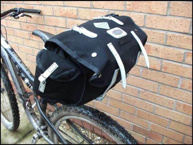 [/img]
PS Three of our group look like there are bailing, so Stuart might have a couple of spaces spare, but you'd better give money to his nominated charity to get in.
Carradice bags are great John, I've a couple in differing sizes and they just get better with use.
Oi flatfish what's wrong with beards? 😉
Stuart, ref your blog
http://welshridething.blogspot.com/
Geoff's been told and is riding with us.
I couldn't reply on the blog, sorry
exactly what i said, your a weirdo!
Plotted all checkpoints on my five 1:25 000 maps, but having trouble seeing the big picture of things due to the large scale and vast areas of paper! No gps or MM here. Cheers in advance for any advice.
Put all the maps in the garden and go up on your roof and look down? 🙂
boingboing, map out your route using something like this
You can then download the route to save it
Nick
Can you enter grid refs on that site?
Don't think so, but it doesn't take long to locate grid ref
There are other tools, I'm currently playing with http://www.mapyx.com/
Cost for maps in 1:25000 for this app, covering the area of the WRT come to £33, which isn't bad really, but if you already have the paper mapss you might baulk at this I suppose.
Thanks, thought I could not get GRs to go in, will have to stick to my paper as well as boingboing
Nick .. thanks for the Bikehike link. I can plot the route from the OS map, see distance and altitude details and download to save. Nice.
OMG just 19 days to get fit
Wow, bikehike is really neat. I was hanging on to an old windows PC with tracklogs on it since moving over to Mac, but I can see myself using this website a lot more instead 🙂
It's much more plannable on the 2 main 1:50,000 maps 135 and 147, I'm using those but have local knowledge as well.
Stuart, I can confirm we have 2 bailers from our gang and another who always bails but say's he's 50/50 at the moment.
Do you have a reserve list to call up?
Route sorted
All 13 points
120 miles
19,706 ft of ups and downs
Don't worry about those not coming John ... the Air Ambulance will still get their money 😀
You have remembered to include the good descents in your route and not do them back to front turning them into climbs? 😉
Stuart
I've got my 2 day route sorted. 10 check points, 145km... decided not to look at ups and downs. There's definitely at least one push/drag across a featureless moorland. 😉
I'm just hoping it warms up a bit...bbbrrrr......
All sorted here too. I reckon on it being 95% ridable and I'm no riding god, although whether I'm still saying this with 25lb of kit on me and the bike remains to be seen. A little challenge, theres an easily ridable,perfectly legal, route directly linking 2 of the checkpoints which isn't on any OS map or Google Earth version I have seen, it cuts out about 3 miles and a big climb. Anyone know it?
