Home Forums Bike Forum Long Mynd Trails Map

Viewing 29 posts - 1 through 29 (of 29 total)
  • Long Mynd Trails Map
  • swoosh
    Free Member

    Having read the article in Issue 63 about the Pods in the Long Mynd and all the work that’s being done regarding trail signage I thought it would be a good idea to get hold of a copy of the map that was mentioned. I’ve looked on the NT site, Blazing Bikes, MTB Shropshire sites and can’t find it anywhere. I found reference to picking it up in the shop or the pub but it would be nice to have the map before hand so I can plan a route.

    Anyone got it? If so where did you find it?

    Cheers

    Speshpaul
    Full Member

    http://www.plushhillcycles.co.uk/

    Call in and have a chat will Al. He’ll point you in the right direction (up from his shop:-)

    swoosh
    Free Member

    I could do that but it wont help me to know where i’m going before I head the the Long Mynd.

    Scamper
    Free Member

    The NT did do a basic map circa 1995, and last time i enquired 3 years ago it was still the same, and basically just showed the main bridleways and footpaths.

    An OS map shows the bridleways, and if its a clear day, its all pretty straight foreward.

    Mounty_73
    Full Member

    Have you asked these guys?

    http://www.blazingbikes.co.uk/

    Sorry, just read your post again 😉 But I’m sure one of the shops could email something over if you asked nicely ! 😉

    lowey
    Full Member

    [/url]
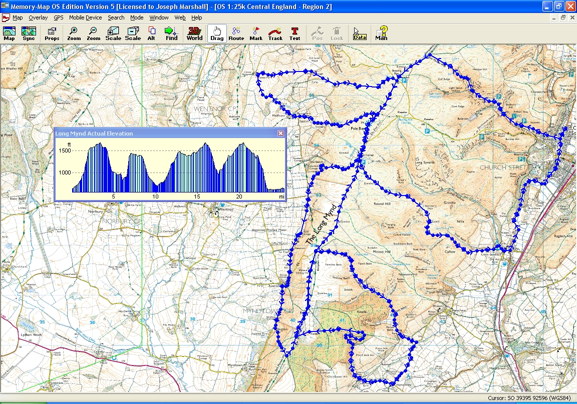
    Long Mynd[/url] by lowey.com[/url], on Flickr

    Click to make big.

    One I did last year..

    swoosh
    Free Member

    But I’m sure one of the shops could
    email something over if you asked
    nicely !

    I was considering doing that actually. thought i’d just ask on here in case anyone had it first.

    Speshpaul
    Full Member

    Oh you almost see my house on there.. i’m waving…..

    Speshpaul
    Full Member

    And you could always try opening the local routes link on Al web site…you can take a horse to water……:-)

    swoosh
    Free Member

    Speshpaul – I think you’re missing the point of what i’m after. I don’t want a route to follow, I would like the map showing all the routes & bridleways in the area and which should be ridden as climbs and which as descents. I want to be able to work out my own route using the info from that map and the OS.

    Speshpaul
    Full Member

    So follow the BW, BOATS, RUPPS, theres no cycle only trails.
    Just make sure you go down minton batch and not up it ( famous MBR route)

    andy7t2
    Free Member

    i did have one given to me by a mate at work not great, it’s better to have an os map

    Just a quick heads up

    best legal decents we have done are

    Pole cottage to little stretton footpath but allows bikes
    BW Minton batch
    BW Plush hill to woodnall
    there two decents from jack minton way to minton which we have never done decents but not great climbs very steep to start with and grassy
    climb
    there’s a decent from pole cott past stanbatch to the road that’s fast and rocky but its wide track and not technical at all
    theres a fire track climb from priors holt to the gliding club thats pretty easy

    Carding mill valley is a good climb only cleared it a few times

    oscillatewildly
    Free Member

    lowey – do you have that as a .gpx file, ive also wanted to try long mynd for a while! the stw mag made me want to give it a try! why on earth didnt they print the route in the mag? whats the point of telling us a story about it all if we have no idea of the route, fair enough if you know the area, but say as the OP travelling to it, would have been easy enough to actually show us the route – unless of course its some big secret 🙁

    Scamper
    Free Member

    Swoosh – just get an OS map as the above blue route shows which bridleways to go up and down easily enough. There is other good stuff off the `top right’ decending down into All Stretton and the awesome Minton Batch is the decent highlighted second bottom left with the fire road climb bottom left.

    As said cardi mill climb is good, but in summer not worth coming down as very busy with walkers.

    lowey
    Full Member

    Oscilate… sorry, dont do gpx. I logged it on my tracks but the gpx export from that usually contains no data.

    Dead easy to follow on the ground though.

    Pics are here :-

    [/url]
    DSC04184[/url] by lowey.com[/url], on Flickr

    lowey
    Full Member
    alfagtv1969
    Free Member

    Went there a couple of weeks ago, very tough climbs, took an OS map, its fairly obvious once you are there.

    Scamper
    Free Member

    From 15 onwards on the lowley link above is basically the decent into All Stretton I was referring to.

    An OS map is also useful as there is a good chance of getting lost on the top if the weather is poor.

    plushhill
    Free Member

    swoosh: send me your address and I’ll pop one in the post, we have a stack of them here for free. Cheers

    plushhill
    Free Member

    info@plushhillcycles.co.uk (might help)

    Speshpaul
    Full Member

    Hi Al coming riding on sunday:-)

    plushhill
    Free Member
    Nick
    Full Member

    CMV is a better climb than descent, at least it’s difficult in that direction and the walkers cheer you on 🙂

    buzz-lightyear
    Free Member

    Ta for the map

    plushhill
    Free Member

    Free hard copies of the map at the shop. Also, we are re-printing soon so any feedback on the map or trail markers etc welcome. Cheers

    Big-Pete
    Free Member

    Shame the best descent is a foot path (I hear)

    bullandbladder
    Free Member

    Best not shout about it then, eh?

    puddle-rider
    Free Member

    The Tourist Information shops do a leaflet that costs about 40p and shows all the Bridleways and Permissive bridleways, just pick one up when you are there passing through Carding Mill Valley.
    Best route for first timers has to be;
    Carding Mill Valley to top, along to trig Point, down to raod and along to Gliding Club, down Minton Batch, up Priors Holt back to Gliding Club long road to Pole Cottage, down Pole Cottage descent to Little Stretton, this is a permissive bridleway, and stop at pub in Little Stretton, then if you have the legs back to Church Sretton and cross the main road and do Hope Bowdler.

    Scamper
    Free Member

    Hope Bowdler – some nice stuff around there, although there is the mighty Caradoc too!

Viewing 29 posts - 1 through 29 (of 29 total)

The topic ‘Long Mynd Trails Map’ is closed to new replies.