UPDATE: Reviews section refreshed, redesigned, searchable: Go take a look
Wondering if you guys could point me in the right direct ?
Looking for a decent circular route that takes in Ingleborough summit please. Any consensus on the best decent after taking in the summit ? Dont want to do it as an out and back.
Cheers all.
Legally there's only one BW to the summit of Ingleborough so ...
Avoid the routes taken by the Three Peaks CX race as they are race day only and riding them at any other time will cause problems. That really leaves two routes up. The first starts off as BW but once you get to Ingleborough Cave it's a footpath up and past the entrance to Gaping Gill. There's a couple of sections that will be hike-a-bike (Trow Gill and getting on the summit plateau) but other than that it should all be rideable.
Better would be to head up from Sulber Nick, there'll still be a couple of bits of walking/carrying but not as rough as through Trow Gill.
So, route: Start at Ingleton, minor road to Clapham, up through the tunnels, turn left on to Long Lane (this overlooks Trow Gill BTW), past Thieves' Moss to Sulber Nick, turn left and up to summit, descend to Ingleton.
Probably best done very early in the day to avoid walkers as the Sulber Nick path is the last bit of the Three Peaks Walk but is also popular in its own right.
There is only one BW way up Ingleborough (up from Ingleton), so if that bothers you it will have to be an out and back. Likelihood of mardy walkers is high at the weekend.
Otherwise, it depends on your preference for carrying/riding. The descent to Crina Bottom is steepish tech at the start, more or less rideable after that IIRC.
As for the other descents, you have Humphrey Bottom towards Chapel-le-Dale - unrideable tech just off the summit, then a very steep section of steps followed by flagstone path. Wouldn't be my choice, mainly because the return to Ingleton on the side of Whernside will either be road or verrry boggy.
Towards Clapham you have two choices - via Little Ingleborough and then another section of fairly steep stepwork, then Trow Gill, or a small section of unrideable carry down towards Horton, then decent track heading off before branching into Crummackdale and finishing down Long Lane. This offers your best chance of a loop without loads of road.
The other ways are towards Horton, which is quite dull for the most part, and parts of the three peaks CX route which shouldn't be ridden outside of the race because you will seriously piss folk off and possibly jeopardise the event (Simon Fell/Cold Cotes).
Hi,
Ingy is type of up'n'down challenge.
Good one, but watch for the wind. It is not called Windy Mountain without a reason 🙂
Pop into Ingleton YHA hostel and ask about Paul, one of the staff there. He knows area like a back of his hand and I'm sure he can suggest good extension to keep you entertained.
Cheers!
I.
Oh, and take a map/compass. Finding the correct way off the Ingleborough summit plateau in poor conditions is not without its difficulties.
Oh, and take a map/compass. Finding the correct way off the Ingleborough summit plateau in poor conditions is not without its difficulties.
Ha Ha!, Hmm. Back when I were a lad the school would organise fell walks. One such was Ingleton to Horton over Ingleborough. The coach drops us off at Ingleton and heads round to Horton to await our arrival. It's a claggy day and having had lunch on the summit we set off down to Horton only to find ourselves looking at Crina Bottom! Back up onto the plateau, follow the edge and drop down to be on the track to Cold Cotes! After several more attempts we descended back to Ingleton and the teacher had to ring round (this was decades before mobile phones) the cafés and pubs in Horton to find the coach driver and get him to pick us up back in Ingleton.
. It is not called Windy Mountain without a reason
It's not called "windy mountain" full stop. That's Pen-y-Ghent - Hill the Wind.
Ing is some sort of Saxon for the people, le is old french for near to, and borough means fortified settlement. And ingleborough was indeed an iron age fort.
And ingleborough was indeed an iron age fort.
Seems like a daft place to shack up. Helluva walk to the shops in Ingleton too.
Anyway, I only meant to post to say that the bridleway up and down is not worth riding. And if you can ride the top bit down without dabs (which can be ridden) you're doing better than me. Actually the middle section has a few 100m of okay riding. The vertebrate guide has an I hear okay 'legal' circuit, and the relatively (for this part of the dales) unvisited Crummackdale gets ridden (again, good bit's short).
Also, I'd avoid the stupidly popular 3 peaks walking route, and cyclocross for reasons already stated. It's hung by a thread some years. I'm all for cheeky riding in the dales and do a certain amount, just well away from the three peaks.
Seems like a daft place to shack up. Helluva walk to the shops in Ingleton too.
You'll know the story of the collapsed building on top, that was inadvertently demolished in the course of the party to celebrate its opening? All highly googleable I'd imagine.
They're not exactly party animals in that part of the dales so I find this hard to picture. Must've been Lancastrians.
Must’ve been Lancastrians.
Celts, apparently. According to some, it was a post-divorce pad for some king or other. So a mid-life crisis build, basically.
I did this last year, took the BW up (which is ridable anyway) and came back down the same track (to avoid upsetting any walkers) I quite enjoyed the challenge of the climb up (then being familiar with the terrain for coming down) so I could have a blast down. I did it in the pouring rain though, good thing about the BW is that the weather won’t effect you coming down or going up, if there’s been heavy rain (like at the moment), anything that goes over the moorland or doesn’t have a proper stony track won’t be much fun when it’s wet.
Celts, apparently
In 1830?
Ah you mean
ingleborough was indeed an iron age fort.
Not
You’ll know the story of the collapsed building on top, that was inadvertently demolished in the course of the party to celebrate its opening
The original fort, not the round tower. 🙂
Seems like an odd location for a hospice, but presumably so that half the prospective residents would be seen off by the trip up.
I would put a fair wager Chris Askrigg would be the closest to anyone that can possibly ride some sections of the bridleway as marked on the OS map and even he would struggle to do the lot on a single bike. There are 2-3' vertical bunny hops I'd think would be impossible on a eBike but perfectly doable as a one off on a trials bike .. then the top section which conceivably could be done on a eBike... and some of the middle bit where you can ride but its no fun because its small 6" drainage steps every bike length...
All this assuming that you can actually stand up in the wind ... I was literally blown over several times carrying the bike..
Oh, and take a map/compass. Finding the correct way off the Ingleborough summit plateau in poor conditions is not without its difficulties.
Ha Yes, unlike the three idiots doing the Three Peaks who had to be rescued on Sunday night. One headtorch between them and their only means of navigation was a phone app. They threw in the towel when the headtorch battery ran out and their last remaining phone with a working battery got to 17%
ris Askrigg would be the closest to anyone that can possibly ride some sections of the bridleway as marked on the OS map
I'm talking about descending. My memory is shite but I remember getting off for a bit at the top that felt like it should be doable? Perhaps not, or there's a carry I don't recall. Whatever, it's mainly rideable and I don't think the drainage stuff was that much of a big deal. There's a nice technical down into and up from a stream I was happy to have ridden.
Christ I'm starting to sell this now when I came on to post it's not worth it.
So in summary, I'll most likely be shot/ drawn and quartered for doing any cheeky stuff on a weekend yes ? Point taken about he cx and 3 peak route.
Might just do a loop around Ingleborough and finish off with an out and back along the bridleway.
Cheers all.
Seems like an odd location for a hospice, but presumably so that half the prospective residents would be seen off by the trip up.
a house of shelter or rest for pilgrims, strangers, etc., especially one kept by a religious order.
Midweek cheeky in March 2018 under dry conditions. Over Ingleborough *before 8am* and then Simon's & Park Fell (steep descent) to Ribblehead. Returned to Ingleton via Scales Moor BW. Riding solo I rarely get negative comments from out of season midweek walkers!
[img]  [/img]
So in summary, I’ll most likely be shot/ drawn and quartered for doing any cheeky stuff on a weekend yes ? Point taken about he cx and 3 peak route.
Might just do a loop around Ingleborough and finish off with an out and back along the bridleway.
Not at all. We're in the lull period between end of the summer hols and half term, and with this weekend's forecast in mind, I don't think it will be super busy.
Tour of Ingleborough is very XC in nature, and will be pretty boggy on Scales Moor between Ingleton and Ribblehead. I can guarantee you won't fancy turning off up Ingleborough after doing a lap, so maybe do that first!
I quickly sketched out how I would do it, starting in Clapham. Not quite a loop, but close enough, and you could make it more so if you fancied some pitched steps off Little Ingleborough.
https://ridewithgps.com/routes/31227058
It's not bang on track, particularly at the head of Crummackdale, where a look at the aerial will probably reveal the bit of singletrack I'm aiming you at. The only other bit I'm slightly unsure of is the doubletrack between the Horton path and Gaping Gill. I know it can be a bit damp down there, so that might be a bit hard going. But it is mostly downhill.
It goes slightly off-piste at the gate at the foot of Trow Gill to get you over to the top of Long Lane again.
Not as much climbing as I thought, though! I reckon 95% rideable, with some get off and push/carry on the limestone pavements and near the summit. Watch out for the steps at the top of Trow Gill. Slippery as..

Martin - what's the path across Thieves' Moss like? I've always gone on to Sulber Nick, followed the footpath then cut right after the gate. There's a vague track leading to a gate in the corner and you then follow the wall until you get to a stile and get over there to pick up your marked route where it makes a sharp 90deg right.
I've run along that track between the Horton path and the top of Long Lane but it's so long ago I can't remember much about it. The 1:25k map has a track marked going from the top of Long Lane around the back of Trow Gill but I don't remember ever actually seeing it. Trow Gill's quite impressive so worth the short hike-a-bike through the top of it.
My wife did Scales Moor going Ingleton-Ribblehead on Sunday and apparently it wasn't too bad, very slippery getting up Scar End but apart from that fine.
I've done both ways and it is much, much better, Bob. You go through the little gate on the right just before the gate you mention, there's a steep drop down on to the pavements then lovely singletrack which curves all the way around to join the way you described, but on the other side of the stile. So you don't have to go through the muddy cowfield or hoick your bike over the big stile. 🙂
You can also follow a track which turns right after the BW gate and runs along the edge of the escarpment before dropping into aforementioned cowfield.
Thanks Martin. Looks spot on that does.
Just a quick query, instead of doing the Summit as an out and back whats the path down from Little Ingleborough to gaping gill like ?
True story, as a child I had to take an alfresco shit in Trow Gill after my old fella misjudged how long it would take to get back to the car.
Only walked it, but a longish section of steep pitched steps off Little Ingleborough IIRC.
I had to take an alfresco shit in Trow Gill after my old fella misjudged how long it would take to get back to the car.
#nettlearse
I’m talking about descending. My memory is shite but I remember getting off for a bit at the top that felt like it should be doable? Perhaps not, or there’s a carry I don’t recall. Whatever, it’s mainly rideable and I don’t think the drainage stuff was that much of a big deal. There’s a nice technical down into and up from a stream I was happy to have ridden.
Christ I’m starting to sell this now when I came on to post it’s not worth it.
LOL... I just checked photo's some of the steps are as big as a 650B wheel... and the last slog at the top is pretty close to 40 degrees and steps... ALL THAT SAID ... it was worth doing ONCE.
So you're saying it will go OK on a 29er?
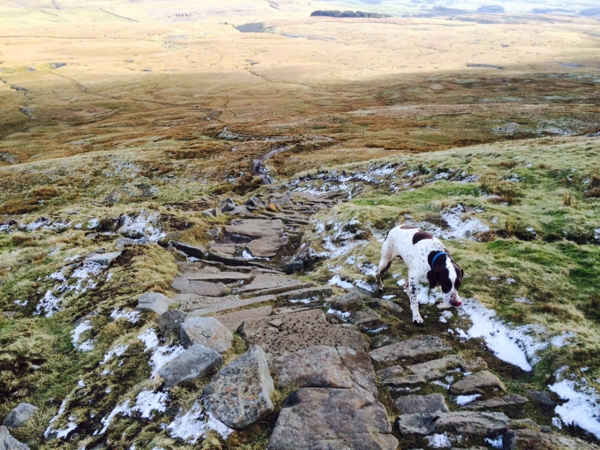
here we go - found on youtube and not watched all -but this is the bridleway descent. It's not that bad.
From that video it looks like they've extended the steps right to the plateau now, it used to be that they stopped about 20m short of the edge and there was just a massive jumble of blocks to negotiate, hard enough on foot.
Yes it is. The one I've done is the footpath marked as "Sulber Nick" then the footpath that leads south past the "Area of shake holes" to cross the wall near "Grouse butts". The alternative Martin mentions is the black dashed line just above your location arrow.
Here's a shot of the steep bit he talks about. The path/track goes to the right of the small patch of water.
Thanks Bob. Yep I've been down Sulber Nick before so looking forward to Martin's alternative.
Just after that little bit of downhill, the path splits and you need the one which stays closest to the escarpment on the left. It's pleasant riding on level singletrack, mainly, with stonking views, so typical Dales garbage.
Also, watch out for that spooky looking child, he's always there.
Looking forward to seeing how you get on - you doing Little Ingleborough or the grassier bit down to Gaping Gill?
I might have a wander over the top of the summit and have a look at it, if its a goer I'll probably have a bash, if not I'll take your route. Also probably miss Trow Gill and take the track around the top of it ....
http://www.streetmap.co.uk/map.srf?x=375437&y=471923&z=115&sv=375437,471923&st=4&ar=y&mapp=map.srf&searchp=ids.srf&dn=580&ax=375437&ay=471923&lm=0
Thanks very much for the route mate. If I can ever return the favour....but i doubt you'll need it with your experience.
I must admit, there's no way I'd be trying to ride into Trow Gill in the wet, but I assume most people are significantly braver and better than me. Limestone polished by thousands of walkers, like Cavedale on steroids. Maybe I'm just offering it up as a counter for people who claim there is no tech in the Dales!
Hope it turns out well for you. I'm sure you can return the favour with all the higher stuff in the Lakes I haven't done.
@lowey - that track is the one I mention above that I can't remember ever seeing (see my post from about 22hrs prior to this on).
I'd make one alteration to Martin's route: when in Wharfe turn right and follow this BW http://streetmap.co.uk/map.srf?X=377922&Y=469430&A=Y&Z=115 - the track Martin has marked is the main access to the hamlet and was tarmaced last year. The BW indicated is much nicer.
Also Martin's track has you dropping onto Thieves Moss slightly too far north: when you get to a gate on the main path there's another smaller gate in the wall to your right, take that smaller gate and you will be at the point the shot above was taken from.
Brilliant! Thanks Bob.
If you don't mind going cheeky, I did this route a few years ago, quite enjoyed it:
https://www.strava.com/activities/575904207
EDIT: Dislaimer, it was a really nice sunny day, dry, and very few people about except for at the very top of Ingleborough, where it looked like two coaches has suddenly arrived and kicked out all of the passengers.
That's interesting, looks like the Trow Gill bypass is a definite thing! What are those steps off Little Ingleborough like to ride?
@martinhutch , really depends on your skill level. I did push down some spots, but also remember having great fun coming down so must have ridden a good amount. But it was 2016, so memory isn't 100% on what is rideable.

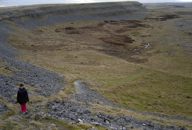
Looking down to Little Ingleborough
Section of steps down to Gaping Gill
Can't really find many good photos of the steps down.
I do really want to go back and revisit that route at some point though.
Midweek cheeky in March 2018 under dry conditions. Over Ingleborough *before 8am* and then Simon’s & Park Fell (steep descent) to Ribblehead. Returned to Ingleton via Scales Moor BW. Riding solo I rarely get negative comments from out of season midweek walkers!
This looks good too....how was the descent? better than just returning on the B/W?
Well, this thread re-piqued my interest, since I hadn't been up there for a fair while. 🙂
[url= https://live.staticflickr.com/65535/48837315356_9e13f64309_c.jp g" target="_blank">https://live.staticflickr.com/65535/48837315356_9e13f64309_c.jp g"/> [/img][/url][url= https://flic.kr/p/2hpA1oy ]IMG_20191003_122442[/url] by [url= https://www.flickr.com/photos/76951366@N02/ ]hutchinson2017[/url], on Flickr
[url= https://live.staticflickr.com/65535/48837490402_21a6c1d08b_c.jp g" target="_blank">https://live.staticflickr.com/65535/48837490402_21a6c1d08b_c.jp g"/> [/img][/url][url= https://flic.kr/p/2hpAUqA ]IMG_20191003_115328[/url] by [url= https://www.flickr.com/photos/76951366@N02/ ]hutchinson2017[/url], on Flickr
Overall, no surprises - the way up is all rideable except for a couple of shortish sections just after you join the main Horton track, and a proper carry for the last few hundred feet.
Descent via Little Ingleborough - I was in self-preservation mode, so had a foot down fairly frequently and pushed down the steepest steps, but, on the whole, I reckon pretty much entirely rideable with a couple of awkward spots for a competent Lakes rider. The steps are made out of grippy sandstone rather than sheet-ice limestone.
Turnoff for the Trow Gill bypass can't be missed, it's immediately after the first step-stile you reach after the summit.
All in all, the route is a good'un, I think. Unfortunately my brake lever clamp decided to explode into pieces just after Moughton Scars, so I short-cutted and don't have a full GPX for you.
It was blowing a bit and blimmin' cold on top today. Didn't even hang around for a summit photo, so take some decent layers if it's looking as grey as today or windy.
Good Stuff. Cheers Martin.
I'm going to get flamed for this but......
Is the three peaks race really a good reason to avoid riding other routes?
Seems really elitist and silly to me. Why should some people be allowed to ride it but others not?
