I've not ridden the Mynd for a couple of years. I used to love the very fast Pole Cottage descent, and there used to be some great little dh runs in the trees at the top of the climb from Priors Holt.
I've always been intrigued by Ashes Hollow, sadly it's not legal, but has anyone ever 'accidentally' gone down that way? It looks like the longest descent on the hill to me.
Looks like a great day out, must make a trip over soon. Dug the MTB out of the garage yesterday for the first time since the spring on the back of this thread. Cheers guys.
Top place to ride the Long Mynd pop into http://www.mtb-shropshire.co.uk/
Also if you need any route info pop in to the shop at Marshbrook, were always willing to give advice on the best route and plenty of parking, showers, cafe, pub, camping, bike shop, hire, demo, etc... down here
Its a terrible shame to walk a bike down Ashes Hollow in the evening or early morning, most of it 'seems ' rideable with some tricky trialsy rock / stream bits.
Apparently Ashes Hollow is fantastic. So I've heard...
How do you spot ashes hollow? I'm going for a walk early tomorrow am. I remember riding up along the long road passed/through the gliding club/passed the start of minton- is Ashes at the start of the steep road/downhill that winds down?
HANG ON- POOK to the forum. I think we've ridden it.
We got lost and I ended up riding down a steep drop/steep face down from the middle of a golf course that goes through alot of thorn bushes. I think we turned up it again to gain height after we were totally lost.
hora - dig out the vid on my vimeo. I'm on my phone in a meeting so can't look just yet.
streetmap has a great search function now too that would find it
edit: we didn't ride it. Could've done with a final shuttle up....
http://streetmap.co.uk/place/Ashes_Hollow_in_Shropshire_454611_303611.htm
It is a great walk.
Get on top of the Mynd and onto the Jack Mytton Way. Proceed to the trig point. From the trig point there is a stony doubletrack. Follow this doubletrack to the road. Turn right onto the road and on your right shortly you will see a stone wall. At this point look for a 'rabbit' type path on your left and follow it as it twists through the undergrowth. Simply continue to walk down and you will go through Ashes Hollow.
It was signposted 'no bicycles'. Sure its that/right one as as soon as you near the stream it becomes a wee bit gnarly but becomes easy after.
I've also found a better campsite at the foot of it. The climb back up the grassy bridleway was hideous.
There are two adjacent valleys that lead to Ashes Hollow. One has the sign you mention, the other doesn't - which is the one I usually use. As you were walking it doesn't matter anyway! Both lead down to Ashes Hollow and follow through to the renovated cottage on the left and into the campsite you mention. There are some lovely gnarly bits to it but I think about 98% is walkable.
I hope you enjoyed it. If you don't fancy accompanying a too fat and currently too slow climbing knacker I will happily show you around.
J
Didnt see a soul either way. It was wet though :O
I did. Marshbrook-up through forest (lots of trails in there I noticed). Through glider club. Along road-Hollow, up bridleway then down Minton Batch
'Also if you need any route info pop in to the shop at Marshbrook, were always willing to give advice on the best route and plenty of parking, showers, cafe, pub, camping, bike shop, hire, demo, etc... down here'
Based on my first visit to your shop I'd have to agree...based on my 2nd visit about 10 days ago I'd have to disagree with the 'were always willing to give advice on the best...'. Bald headed chap on the counter there was hardly helpful even though I was in a position to spend some money.
Still at least the riding around the LM is fantastic
Slim bloke with yorkie terrier??/livestrong bracelet? IF it was him- Went out of his way to help me- came and found me to give me matches/help.
Didn't see or hear a 'yorkie' nor any bracelets tbh. Shame really the way it turned out as I like the shop nad the camping pods etc...etc
Must be different- he was a inherent goodbloke!
I 99.99% off the time run the shop at the centre! ha i'm not bold though.
I used to work on the paths on the Mynd and know a few of the descents. Once spent ages trying to get a burnt out car out of Townbrook Hollow. Good luck in getting round the stupid non access laws down there.
I only know it from walking and skiing, but Beacon Hill in Radnorshire (not far from the Mynd) may be worth a look. It has a very Mynd feel and some similar but not so spectacular batches
[b][url= http://www.geograph.org.uk/photo/6113 ]The infant Lugg
[img] 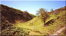 [/img][/url][/b]
© Copyright [url= http://www.geograph.org.uk/profile/196 ]Richard Webb[/url] and
licensed for reuse under this [url= http://creativecommons.org/licenses/by-sa/2.0/ ]Creative Commons Licence[/url].
What it does not have is : The NT and wardens, lots of walkers and a nearby town, so you will probably get left alone.
From Little Stretton across are some bigger hills- those?
