- This topic has 20 replies, 13 voices, and was last updated 2 years ago by nickc.
-
Going straight
-
scotroutesFull MemberPosted 2 years ago
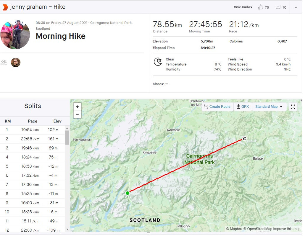
Jenny Graham has just been on another madcap adventure – walking the longest straight line between two public roads in the UK.

That’s a hoor of an amount of climbing!!
https://www.ordnancesurvey.co.uk/newsroom/blog/gbs-longest-linear-walk-without-crossing-a-road
martinhutchFull MemberPosted 2 years agoPfft. Everyone’s had rides like that on Strava.
Reading the article, there appears to be a 5km longer version of the English one right in front of them crossing the same area but at a different angle. Unless I haven’t understood their rules properly.
ircFull MemberPosted 2 years agoThere is some odd walks out there. I liked Dave Hewitt’s 1987 walking of the entire Scottish east west watershed. 850 odd miles.
peekayFull MemberPosted 2 years agoSimilar thing to the chap on YouTube who has tried crossing Wales, Norway and Scotland in a straight line.
https://youtube.com/c/GeoWizard
On a thread a couple of years ago, there was mention of someone who covered the whole of England and Scotland North to South within a hundred metres of the Greenwich/Prime Meridian, but haven’t been able to find anything more about that.
scotroutesFull MemberPosted 2 years agoOn a thread a couple of years ago, there was mention of someone who covered the whole of England and Scotland North to South within a hundred metres of the Greenwich/Prime Meridian
You might want to think about that…
bajsyckelFull MemberPosted 2 years agoYeah, I saw it earlier and assumed it was a dodgy gps trace until I zoomed in. Absolutely brutal mind exercise on some of those sections. Great stuff.
On a thread a couple of years ago, there was mention of someone who covered the whole of England and Scotland North to South within a hundred metres of the Greenwich/Prime Meridian, but haven’t been able to find anything more about that.
Would have thought that unless they were packrafting oil platforms, it probably ends somewhere in the midlands. Do like pointless lines to follow though.
tjagainFull MemberPosted 2 years agoGreenwich/Prime Meridian hits the north sea around Grimsby
that route across the Cairngorms is totally mad – I am just back from walking a north south route and going east west like that you have some mighty steep and rough climbs. Bonkers!
bajsyckelFull MemberPosted 2 years ago@martinhutch – I’m not convinced the OS methods are spot on. Like you say, I would have thought a bit longer is possible too. Also you can get some long routes in Northumberland/Cumbria starting on the scottish border and crossing kielder/wark forests both N-S and E-W ish. For example I get over 31km just north of Haltwhistle on the miltary road, heading NNNW to the road between Kielder and Deadwater farm. Similar going from road by Kershope roughly E to the minor road between Shitlington and Hesleyside. Maybe even squeeze another km out going from Kershope to a few km NE of Stonehaugh… Forest tracks aplenty, but the others mentioned also cross estate tracks/ farm tracks/ forest tracks/ so it can’t be that – perhaps the OS method/database is a bit out?
scotroutesFull MemberPosted 2 years agoAs mentioned, they had to do an extra couple of km as the OS got the end point wrong.
martinhutchFull MemberPosted 2 years agoForest tracks aplenty, but the others mentioned also cross estate tracks/ farm tracks/ forest tracks/ so it can’t be that – perhaps the OS method/database is a bit out?
Looking at one of their graphics which has the ‘roads’ highlighted to avoid, it seems that many of them are just estate tracks, but their actual line seems, as you say, to cross others, or forestry tracks, which would be equally ‘driveable’.
I traced a line from Melmerby off the side of Cross Fell, to near Middleton-in-Teesdale which was about 37km. Apart from the Great Dun Fell approach road, and the track alongside Cow Green Reservoir, I can’t think of anything else which has to be swerved.
tjagainFull MemberPosted 2 years agodon’t forget in england some of those tracks are legaly roads ( of a sort BOATs)
bajsyckelFull MemberPosted 2 years agoI traced a line from Melmerby off the side of Cross Fell, to near Middleton-in-Teesdale which was about 37km. Apart from the Great Dun Fell approach road, and the track alongside Cow Green Reservoir, I can’t think of anything else which has to be swerved.
I get ~ 34km on bikehike, again avoiding the reservoir/radar roads. AFAIK also would all be access land under CROW so could be a winner.
[edit @TJ – no worries on these cases – no byways/boats crossed if that were an issue]
konagirlFree MemberPosted 2 years agoThe OS article says their method was to search between “roads navigable by car” in the OS MasterMap Highways road network, so not exactly the same thing as was asked, which was about tarmac or metalled roads. That is probably why the OS search didn’t find all the suggestions that include farm tracks or forestry tracks, because many (especially things like wind farms and driveways) may be in the Highways database as ‘roads’ even if not tarmac / metalled or publicly accessible and so the OS didn’t count routes that had gravel roads intersecting them. You can see in the OS article the blue lines overlaid on the OS map where the ‘Highways’ database ‘roads’ run.
It’s interesting the walkers said following a compass bearing wasn’t that accurate, I presume because it is hard to identify a point to head towards within a few degrees, versus keeping to a point on a handheld / phone GPS. Also interesting how much additional ‘distance’ Strava gives compared to the mapped horizontal distance, which excepting for their extra 1.5 km to reach a tarmac road must have been mostly ‘noise’, error in the GPS positioning on their device and meandering a little off the ‘straight line’ on the map (which of course is really an arc/parabola in 3D space).
NewRetroTomFull MemberPosted 2 years agoOn a thread a couple of years ago, there was mention of someone who covered the whole of England and Scotland North to South within a hundred metres of the Greenwich/Prime Meridian, but haven’t been able to find anything more about that.
I suspect the reference is to Nick Crane’s “Two Degrees West” book. Berwick upon Tweed to the Isle of Purbeck.
ircFull MemberPosted 2 years agoIn the fine tradition of madcap rule based stuff. Munro bagging etc. LE-JOG. Dave Hewitt walking the watershed. Or my favourite – the Crane’s ride to the centre of the earth.
jimfrandiscoFree MemberPosted 2 years agoThe Crane book is an absolute must read if you can – it makes modern bike packing looks way too comfortable and over equipped. Crossing the Himalayas on 28mm tyres with, literally, just the clothes you’re stood up in.
Jenny Graham is nails, will enjoy watching that vid later.
nickcFull MemberPosted 2 years agoFor some reason Jenny Graham hits a nerve with me, can’t watch that.
The topic ‘Going straight’ is closed to new replies.