Forum menu
http://www.grough.co.uk/magazine/2014/08/16/night-rescue-for-two-lost-yorkshire-three-peaks-walkers
Two walkers had to be rescued after they got [b]lost[/b] while attempting the Yorkshire Three Peaks.“The lost walkers were quickly located, cold and frightened, at the Sulber finger post, and brought down off the hill by CRO vehicle.”
How exactly can you be lost when you are standing next to this?
[img] 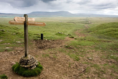 [/img]
they were presumably lost until they arrived finger post. In that case he question would be how long they'd been lost until they arrived there and how cold/wet/hungry/tired they were by that point.
Given that 'night' is in the title of the article they may have been found in the vicinity of the signpost, not necessarily in sight of it.
Good grief. "Horton this way" not a good enough clue?
perhaps they could not read
Am I missing something??
Yeah probably.
Horton hears a who?
[img]  [/img]
Horton, yesterday.
[Actually, this may be complete bullshit Photochoppage. The giveaway is the blue sky]
One would imagine that anyone attempting such a thing would, at the very, [i]very[/i] least, be reasonably proficient in, a) reading a map, and b) using a compass.
Still, I don't suppose you can legislate against stupidity and incompetence.
Sadly many seem to wander into the hills without those two skills. The almost universal adoption of GPS doesn't help.
was called out about 9.50pm yesterday.
So it was night time then.
Perhaps being in pitch darkness with no lights made finding their way home very difficult.
Perhaps they should have (a) been off the hills before it was dark and/or (b) had lights with them.
[quote=gofasterstripes ] The giveaway is the blue sky]
I thought it was the pterodactyls hovering overhead.
These are not difficult hills to navigate. Even at night.
Perhaps they should have (a) been off the hills before it was dark
Perhaps they got lost ?
why ever not? Beats the crap out of a map in the dark, IMOThe almost universal adoption of GPS doesn't help.
They probably assumed a strong 3G signal and google maps would suffice.
[quote=ernie_lynch ]
Perhaps they should have (a) been off the hills before it was dark
Perhaps they got lost ?
How exactly can you be lost when you are standing next to this?
[img]
[/img]
I suppose it depends on the weather conditions as well we went to do Black Combe the other week coming up the back side of it to ride down the Whicham side bloody straight forward on the map, reality was completely different.
We go lost. Had the map the compass but the trail we were on slowly vanished in front of our eyes into the heather and then the low cloud rolled in and visibility dropped to 15 feet.
So we carried on knowing the path we should be on was just ahead after 40 mins of hike a bike through high heather we were pretty ****ed.
The cloud turn day to pretty much late evening and we had to make a decision. As the path we were trying to find just did not seem to be there.
Final look at the map and we made a call just to get the **** off the mountain before it became really dark, we followed a stream back down the fell which took us back to were we knew where we were.
Looked at the GPS track the following day we we approximately 350 meters from the trail when we turned back, sods law but we will do it again another day.
I could see how less experienced people may have been dialing the mountain rescue in a similar situation.
The signs did give it away to them but unless you were there on the day in the weather they were in it was there call to make. I suppose.
How exactly can you be lost when you are standing next to this?
Perhaps it was night time when they located that ?
"at the" may be a general description, I guess, or maybe they only got lost every time they walked away from the post 😉
"lost" maybe just = "unable or too scared to make their way without assistance"
[quote=ernie_lynch ]
How exactly can you be lost when you are standing next to this?
Perhaps it was night time when they located that ?
If they'd had some lights they'd have been able to read it too.
If they'd had some lights they'd have been able to read it too.
This suggests that they were perhaps able to read it :
[i]A team spokesperson said: “After obtaining further details from them a CRO team drove up to the Sulber ‘crossroads’ area [/i]
I do wonder how far they'd progressed on their three peaks route, and if they were doing it for a charity.
Call me an old cynic if you like.
Horton yesterday
Don't remember passing that in Ribblesdale.......
it is 2.41 miles from sulber xroad to horton.
i wonder if they were terribly embarrassed? i would have been.
How exactly can you be lost when you are standing next to this?
I don't think they took that photo and I don't imagine they spent their entire time lost standing still next to a sign post waiting for it to go dark.
I suspect that the main problem was that they weren't all knowing Singletrack keyboard warriors.....
I got lost in the Southampton Ikea car-park once - there were lots of signposts, but I still managed it.... and it wasn't even dark.
That is very different batfink. IKEA, like the eye of Sauron, casts a shadow of impending doom on all men (and I am being gender specific here) who venture within sight of it. The resulting feelings of dread and the desire to simply lie down and die render men incapable of tasks they would ordinarily excel at.
Lots of folk who have never been out in the hills get tempted onto routes like the 3 Peaks, and I can imagine how scary it is when it gets dark.
If you've been wandering around in the dark for a while, scared, cold, and tired (you've already done about 22 miles at that point), and you find a fingerpost, if I was in the CRO, I'd rather you stood next to it and called for help rather than try to head off again and end up calling when you have no useful location information to give to mountain rescue.
OK, they might have made it down to Horton, but given their competence, they might equally had headed off onto the limestone pavements above Crummackdale, twisted an ankle etc. Then found they had no mobile signal.
The lost walkers were quickly located
This is all that really matters. Good job CRO.
Seconded the bit about being tired, cold, hungry and scared. Some people just go to pieces and darkness falling would freak them out.