Trying to climb into a sleeping/bivi bag with a broken leg can be quite difficult I hear,
When I was much younger and plastic emergency bags were the thing it was recommended to punch a few holes in the bottom of the bag, then slip it in over your head and sit up (if possible/on your rucksack). That keeps the core warm and reduces heat loss to the ground. (The holes are obviously for ventilation).
The thin foil blankets aren't very robust but I'm told you can get fairly good results by wearing your jacket over the blanket. Not great for your arms but might be better than the whole thing shredding in the wind.
Many many years ago I was part of the first aid provision at the camp site a fairly large music festival. The weather was as attrocious as you would expect for such an event and as the night wore on a steady stream of people seeking "space blankets" was rapidly depleting our supply, and it was clear that they were having little effect on the worst casualties. Someone commandeered a barn (walls on 3 sides so out the rain but wind still whistling through). We were clearly going to run out of foil blankets so whilst that was escalated we used bin bags - with the corners cut off for arms and a slot for the head - you'll see similar things at large sporting events. They seemed to be at least as effective as the foil blankets - less flapping around. We then fashioned a second bag into a "kilt". We must have "treated" 150+ people that night, and after a couple of hours in the barn with their improvised survival bags they warmed up enough to return to their tents. If you don't want to take a full on survival bag - even a bin bag at the bottom of your bag could be useful.
A couple of years ago on here, there were two simultaneous active threads. One was along the lines of "what do you carry on a ride" and the other "do you carry a first aid kit".
While the first thread was quite well spread across a spectrum from full rucksack with everything mentioned on this thread, for every ride; to a "phone and multitool" unless its a big trip. Lots of people in the middle recommending lightweight hip packs etc.
the second thread was 95% people saying yes they always carry a first aid kit and listing quite extensive equipment.
obviously this was, with some overlap, different people replying. but the difference in answers suggested that people would either only be clicking on threads that they thought relevant, or reading them but keeping quiet if they felt they had gone against the group-think.
So I'll stick my head above the parapet and admit to solo riding without an extra layer, any of the self rescue equipment mentioned, and at night...
My couple of mitigating factors (and this doesn't seem like enough, having read this thread)
- these are woodland trails in the south. warmer temps in general and less wind/exposure than those of you exploring fells and mountains. Unless I'm starting in daylight and finishing under lights, I am fairly sure what the conditions will be for the duration of my ride and dress accordingly.
- there's always at least some phone signal round here, and as a millenial there is absolutley no chance it wont be with me and on. (maybe in the future a cellular enabled smart watch may takee its place)
- on the end of the phone will be my partner (who rides) or a few local riding friends, pretty confident I could describe or send my location to them anywhere I'm likely to end up. Those with non-riding partners or people who only ride solo and thus have no riding mates won't have this available to them.
- and finally, specific to the OP's situation, he seems to have hurt his ankle due to being clipped in and falling with the bike. I've avoided that (although not every potential ankle or leg injury) with flat pedals.
I say all this not as some sort of hardman brag or to disparage what others have said; but to hopefully get others to think about their choices and maybe join the discussion.
Re calling the police for MR. A casualty calling directly will automatically end up with the local force who will (should) know how to contact MR. If you're at home and are calling on behalf of somebody elsewhere, eg, because their tracking has stopped or you've had a text, you need to ask the police call handler to transfer you to the police for the area where the casualty is, as other forces won't know how to contact the right MR team. Not doing this has led to an hour's delay in MR arriving.
I must admit that I have got complacent/become a fashion victim lately with a small bumbag. I always used to carry first aid and safety gear, partly because I was Mr Responsible on most rides. Since I retired I have embraced irresponsibility and often take less than the basics if I can avoid it, let alone bother with "in case" stuff.
Re calling the police for MR. A casualty calling directly will automatically end up with the local force who will (should) know how to contact MR.
Mostly true, but not 100%, from various experiences. If you’re unlucky and the local force doesn’t have any available call handlers, you could end up with a London call handler who doesn’t even know why you wanted Police to get Mountain Rescue…
This has been quite a sobering thread for me, and the recent conditions locally has made me think quite hard about risk and 'what could happen'.
We've not had any snow in Leeds recently, so haven't had that and the subsequent compacted snow/ice/thaw/freeze to deal with. But, we did have the best part of a week of sub/close to zero temperatures following a period of dry weather, in which the riding was AMAZING!
And, then we've had a few days of bits and bobs of rain, temperatures hovering either side of zero, with some thawing/re-freezing. It's been really varied and really really unpredictable; some trails properly thawing out and starting to turn to mud', but a lot of places where the ground has still been too frozen & hard to absorb the rain, and then it's become ice covered in a layer of water. I can usually tell/predict pretty accurately what the local trails will be doing in a variety of conditions, but these last few days have had me totally stumped ... and, on the basis of a few sketchy moments trail running or walking, I made the very conscious decision NOT to go out on the bike until the trails have fully thawed.
But, I might have very easily done so, as like the OP, and others who have posted on this thread, love riding so much and always head out several times every week no matter what the weather ...
If I'd gone out (I'd been having this internal debate), I'd have worn knee pads (I don't usually, unless doing steeper/Enduro stuff) and swapped to flats (which I normally never do); I guess flats might have helped in the OP's case?
I usually ride quite light, certainly locally. I'll carry an extra layer sometimes, although that's usually a decision based on what the weather forecast is for my planned ride duration (light rain jacket if it might rain, minimal extra layer if heading for a beer after and possibly sitting out), but don't usually think to pack 'what would be needed to survive comfortably if something goes wrong'. Having read this thread has got me re-evaluating that a bit, even for the short local rides.
Re calling the police for MR. A casualty calling directly will automatically end up with the local force who will (should) know how to contact MR.
Yep - very mixed experience with this.
In this case - Steathcat76 got put straight through to MR. The walkers I met, had no end of trouble explaining why they called police when they wanted MR.
Another incident I got caught up in at Greno a year or 2 back while doing trailwork, we ended up talking to Northamptonshire police as that's where the call centre we were put through to was - again, "why are you calling us??". That one was solved by one of the group knowing the head of Woodhead MR though organising Steelcity race and calling him direct.
So I'll stick my head above the parapet and admit to solo riding without an extra layer, any of the self rescue equipment mentioned, and at night...
My "load" varies according to where and when I'll be riding. It would be wrong of me to suggest that I always go out with enough kit for a night outdoors. FWIW I used to use a SPOT tracker occasionally, especially when I first moved to Aviemore. I was aware that the trails I was on were often much more remote, I didn't know them so well and, not knowing the area, I might get lost somehow. The SPOT fell into misuse as I got to know the area better AND the availablity of 4G/5G increased significantly. My plans for 2026 certainly involve more remote wanderings again and I'm looking at subscription options for both SPOT and inReach.
This thread has convinced me to buy a bothy bag. My remote solo stuff is in highland glens and the odd hill, often remote less visited bothies. Sometimes on the bike. Mostly walking. If I am on a two night Mon-Wed trip my wife wouldn't raise the alarm until I hadn't been in touch by late Wednesday. An accident on Monday could mean a long wait for help if there was no phone signal. Low risk of course. Worst over the years was a gash on my leg needing stitches where I was able to walk off the hill.
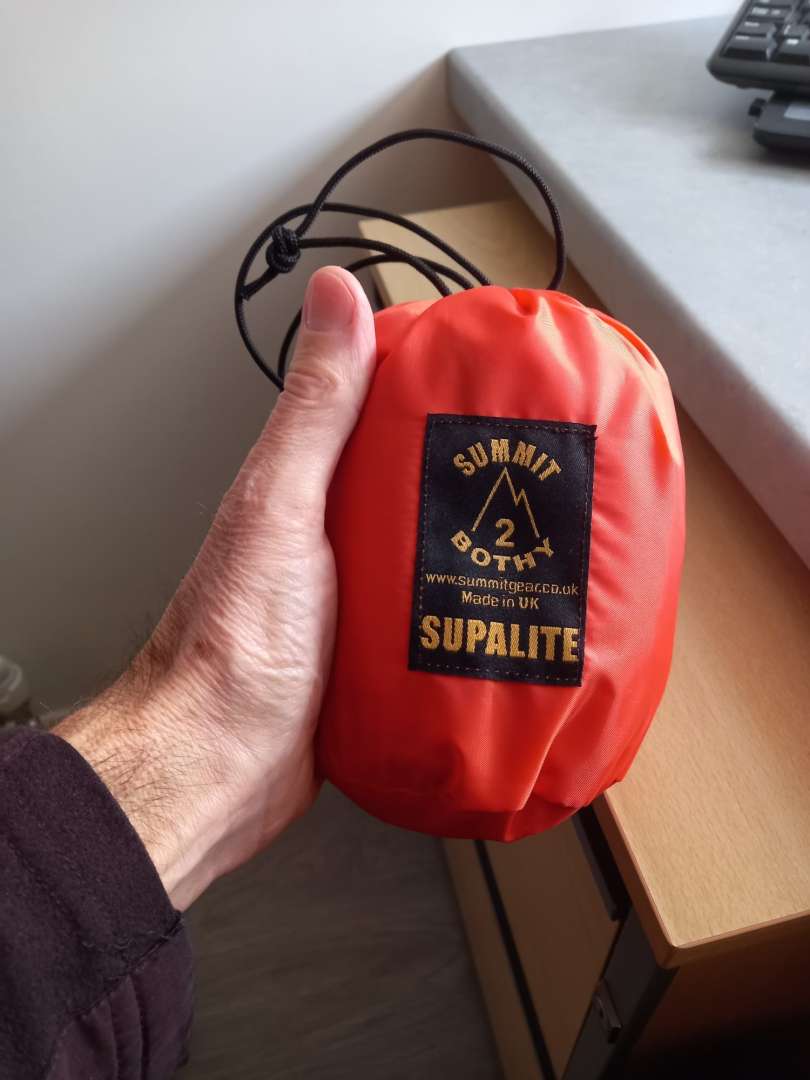
Thinking about the Summit Supalite 2. At 265g who cares if I carry it in the bottom of the sac for years without using it? Anyone used one of these?
https://www.summitgear.co.uk/product/supalite-bothy-bag-2-person/
Yup, I got one of those👆 there bothy bags a couple of years ago. Packed size is conveniently tiny(barely bigger than the palm of your hand) and it'll compress even smaller into the corner of a bag. Big enough for two people with a bit of 'eating space' between them. I think it was on the recommendation of MOAB, or at least a thread thst he was major contributor to.
Thanks. One now ordered.
I have also turned on location sharing from my phone to my wife's phone so if I don't turn up she can at least see where I am.
Always a good reminder whenever a thread like this comes up.
Bothy bags are a really very good investment, and as well as being emergency kit can also be used if you need to get out of the weather for bit. My top tip is to carry another bag to put it in. I used mine with my daughter near the top of Skiddaw in some grim conditions, needed to get out of the wind and the rain to put some food in her, warm up, regroup and add some motivation. Worked really well, but getting it back into the stuff sack is impossible with cold, wet hands. I now put the whole of the bothy bag into a bigger bag that is tied together (so they can't blow away). I can them stow it more easily, dry it out at home and then repack it properly when I'm back. Total weight of the summit supalite 4 person bothy bag with the extra bag is 407g. I don't carry it locally but I do carry it on hill days
I actually leave my other one in the van. Good in case I forget to bring my proper one but also for emergencies. Always worry about having to get out and wait around in grim conditions e.g. by the side of a motorway
This was my post at the end of the first page. Seriously recommend another (bigger) bag to put that into. It's a right faff to repack when it's wet
Always interesting to realize how reliant we are on phones as a society. I always think a fun exercise is to see if you have the right gear to get you through if things go south is stop part way through a ride, take a seat for a few minutes and see how quickly you cool down. If you then imagine your phone either has no reception or is broken, where would you be if you were unable to self rescue? Throw in the temperature dropping as it gets dark or the weather turning for the worse and things might seem not quite so comfortable.
Ultimately, risk is for everyone to assess individually and make a judgement on. Only you can decide if you're comfortable accepting that or want to make changes.
Sometimes things just go to shit despite your best efforts and you find yourself in a situation where things begin to spiral. Outdoor sports all carry a degree of risk. Personally, my tolerance for being unnecessarily cold, wet and miserable is pretty low. I'll happily go out in freezing conditions or when it is pissing down but will prepare accordingly.
Besides, this is all a great excuse to buy kit! 😉
I'm always slightly surprised by how many people think that just because distances to a road or other form of "civilisation" aren't necessarily that far then things can't go to ratshit surprisingly quickly.
My 'oh ***' moment above was about two miles from a village on familiar trails. Had I been unable to walk that would have made no difference whatsoever, I would have been just as screwed as if I was in the middle of nowhere.
The one advantage of having Reynauds is that I always have a couple of dry base layers and a spare pair of gloves with me (made a sling from a base layer in this case)
Ah crap, sorry to read this Jon. You're the sort to heal ahead of schedule, so hope that's the case.
Input on trail conditions......bridges are often a few degrees colder than elsewhere - chilled from below. Was out around the Cairngorms a few weeks ago and some of the tracks had stripes of unmelted snow across them above the large drainage pipes. I'd have gone out and no doubt fallen on your slapey bridge - I broke ribs last year walking/failing to walk on ice.
This thread has convinced me to buy a bothy bag. Thinking about the Summit Supalite 2. At 265g who cares if I carry it in the bottom of the sac for years without using it? Anyone used one of these?
https://www.summitgear.co.uk/product/supalite-bothy-bag-2-person/
Well that was quick. Arrived via Royal Mail this morning. Quick test drive in the house seems good. No way was it going back in the original bag. I stuck it in a slightly larger bag. Now measures 8x4" and weighs 295g. A bit under 1L in volume. So I won't miss the space in a 60L waking sac.
As per my photo a couple of days ago, I thought yesterday "I'd better dig that bag out and put it in my riding pack, with the first aid kit, so it's always with me". Hunted high and low on the shelves of camping/climbing/riding kit earlier, and could I find it? Could I 'eck as like! It's so small (relatively) I've obviously put it somewhere 'safe' and now it's hidey-tidied by me. Grrrr. Cross with myself....
Great thread. I've been thinking about upping my "survival kit" as I've drifted into solo riding with fairly minimal stuff. Regarding Spot Trackers and InReach devices... I read somewhere that Ofcom have laid out a framework for mobile operators to be able to use satellite connections, ie., direct from phone to satellite when 4g/5g isn't available. I think it is supposed to be happening this year. Sorry, no firm details!
Meanwhile I've looked at InReach capable devices but I'm a bit put off by the subscription costs (I'm usually within phone network coverage).
About to order a bothy bag as a starter!
Thanks
I’ve used bothy bags a zillion times with pairs/groups but never solo. From memory a lot of the benefit was from the shared warmth - are they much better than something like a blizzard bag when you’re by yourself?
I’ve used bothy bags a zillion times with pairs/groups but never solo. From memory a lot of the benefit was from the shared warmth - are they much better than something like a blizzard bag when you’re by yourself?
I find them a bit baggy (and therefore blowy) if being used solo. I have a two-man bothy bag and a classic Karrimor KISU (Karrimor Instructor Survival Unit) that will happily take four folk, but I'll take a little solo bag if travelling alone. I also have a SOL Escape which I've actually used as a functional, lightweight bivvy bag.
I just take a bivvy bag. No ideal from groups but isn't terribly heavy and I know it works.
I don't take it every time though, only on rides/runs/walks where I'm taking a pack but not a tent.
Since discovering a couple crashed on the first downhill bit of the blue at Deggers (I was on a second lap having done the black) - the poor lass was impaled on her bars (no end plugs). It was around late March/early April. Only had t-shirts. I gave them my waterproof to keep warm, whilst we waited for the staff to arrive, followed by air ambulance. I carried on at this point. I now carry a foil blanket in every backpack, and when off grid have a emergency bivvy - you never know when or who may need one.
I came off on black ice on the way to work this time last year (with studded tyres) and made a mess of my hip socket and pelvis (I didn't know at the time and dragged myself off the main road). I couldn't walk or ride so phoned home. In the 20 minutes or so that my son took to reach me I got very cold. I had a base, thermal/windproof top that's good to minus 10, and a windproof Gillet - still got cold so managed to put on waterproof top.
I was dressed for riding, not standing at minus 5.
the poor lass was impaled on her bars (no end plugs)
!!! Nightmare scenario.
I was dressed for riding, not standing at minus 5.
I don’t think it’s possible to dress for both. Warm enough to go for a gentle walk is not warm enough to sit outside a pub for an hour.
I was lying on the ground still attached to my bike, it was November and not too cold. But after 15 or 20 minutes lying on the ground I was shivering and that was wearing more than I would've done in a normal riding scenario. Comments were made on how well I was pretending to be cold but I wasn't pretending l, it was a real eye opener to how quickly you get cold when lying still on the ground.
I was a passer by at an incident in the local town centre where an elderly lady walking home from the shops (in winter, some snow and ice) had slipped on icy cobbles, gone over and broken her hip. She was off the main drag but outside some houses and on a popular walking route so there were people with her quickly. Various neighbours from the surrounding houses brought duvets, bedding etc, someone brought a gazebo to put over her. But we couldn't move her and she was still lying on freezing cold stony ground. In spite of the small mound of duvets over her, she was really getting very cold. We were making increasingly desperate calls to the ambulance begging them to escalate the urgency, each time being advised that it'd be about 2hrs.
And this was a woman dressed for the cold in a big winter coat, she'd only nipped to the shops. A fell runner or MTBer out on a hillside somewhere with no duvets or gazebo would have been hypothermic in minutes.
I’ve used bothy bags a zillion times with pairs/groups but never solo. From memory a lot of the benefit was from the shared warmth - are they much better than something like a blizzard bag when you’re by yourself?
The advantage of a Blizzard Bag, I have one somewhere, is that it's (claimed) to be roughly as warm in insulation terms as a medium weight sleeping bag, they say 5.5 TOG, as well as being wind and waterproof, so in the right situation, arguably yes, more effective than a solo bothy bag. You'd have to think about reducing heat loss to the ground, but on balance given the choice of a few hours caught out in a Blizzard Bag or in a solo bothy one, I'd take the added insulation of the former.
I've knocked myself out on a trail a situation where layers or emergency phone aren't going to help, so I think tracking as also important. My Garmin automatically emails a few family members every time I go out and while I know you can't guarantee mobile coverage it's good enough to narrow down the area and direction.
I’m ordering one of those Blizzard bags. What a great piece of kit!!!!!!!!!!!!
I'm rarely in locations where cold is going to be too problematic unless needing overnight shelter, but I carry an emergency blanket just in case.
However, for hiking and (proper) adventure moto riding I used to carry one of these lightweight tarps Escapist Tarp Shelter | Sea to Summit - having seen a few broken leg incidents on rides I realised that waiting for a chopper without shade would be ****ing miserable.
They're really easy to set up off trees, handlebars etc. Once used it for overnight shelter in Tassie when a certain Mrs Reeksy forgot to pack the tent!
Best wishes for you recovery, Jon. Treat it as a project, do what you can to optimise things, make future plans is my advice. I think the problem with risk assessment on stuff like this is that it's one of those things where everything's okay until it isn't, but the more it is, the less likely it seems that it won't be, if that makes sense. I've done some pretty (relatively) high risk things in the past and every time I emerge unscathed, it maybe makes me a little bit complacent - either that or my risk assessment skills are okay.
Really good mountaineers, for example, have a very, very precise grasp of both their own abilities and the risk level/consequence of what they're doing. It's the difference between say, Joe Simpson - who's risk-meter was arguably slightly off - and, say, Leo Houlding, who seems to have the ability to climb just within his own and the environment's limits. And then, sometimes, shit just happens.
I once had a strip torn off me by a thoughtful doctor friend for riding a biggish Peak loop solo in temperatures down to -16˚C with loads of ice and snow around. My calculation was that as an experienced local rider, on Ice Spikers, carrying basic emergency kit and with good fitness, lights just in case etc. I had a cracking day, nothing bad happened, no iffy moments bar the odd slide and I finished by believing I'd taken on an acceptable level of risk in exchange for a really cool day out. I may have been correct in that, I may simply have been fortunate and a random slide could have landed me in a potentially really bad situation. It was cold enough that I finished off riding the home stretch wearing my emergency PrimaLoft jacket.
Ultimately you do what you can to eliminate casual risks and plan to cope adequately if things do go bad. I always think the most frightening, dangerous thing is people taking risks that they don't realise are even there. But it sounds like you were mostly a little unlucky and hit an objective danger that maybe you couldn't reasonably have predicted.
Meanwhile I've looked at InReach capable devices but I'm a bit put off by the subscription costs (I'm usually within phone network coverage).
Garmin aren't the only people that offer data plans for their devices, some are a lot cheaper too! I had these folks recommended to me when I was looking into this myself; Protegear. (the .de website)
Good post by @BadlyWiredDog
My dad took me up the Buachille for my second climb - Agags Groove. On the way up the otherwise easy access path he pointed out a two or the step section as the path crossed of a steep stream/gully. Nothing to it but unlike the rest of the path if you slipped you were going a long way down. A friend of his was killed there walking down after doing hard rock climbs earlier. The danger being relaxing too much on easy ground with a steep drop. Once you are higher up and needing to use your hands scrambling up Curved Ridge the focus takes care of itself.
Message I took was that it isn't how hard anything is it is what the worst downside is if it goes wrong and adjusting behaviour/focus as appropriate. So if I am solo somewhere remote with no phone signal I have at the back of my mind that I can't afford to have an serious accident and thus far have managed 45 years later to avoid doing so bar one occassion when I gashed my leg but could walk off.
Apparently recent iPhones can send an emergency text via satellite if there's no cellphone signal:
https://keswickmrt.org.uk/rescue/dubs-hut-5/
Being a numptie presumably isn't a condition of use.
Interesting thread: thank you.
I've dug out an emergency whistle for my hip bag. I also carry a buff (for tourniquet), phone, jacket and flashing red LED.
My family know, if I go missing, to check my email for a tracking link from my GPS. That and I tell them where I am going and when I expect to be back (not that they ever listen).
If I die on the hill, it will be what I wanted 🙂
Recent local MRT rescues for cyclists have been
1) Rider with broken neck after messing up a jump tucked off the main path. Passing walker heard his shouts, called his wife who called an ambulance. Ambulance turned up, said can't do that and then phoned MRT. Rider is OK.
2) Visitor came unstuck on an evening ride of the Touch Hills. Got lost in heavy rain and had to spend the night out on the hills. Family phoned for help the following morning with the a police helicopter locating him close to his last known position. Coastguard helicopter took him to hospital. Having a map and compass would not have helped him if he wanted to get off the exposed hillside as the OS maps for this area are out of date and next to useless - What look like tracks on the map are knee-deep bogs, while the many shooting and windfarm tracks are not shown.
https://www.dailyrecord.co.uk/news/local-news/missing-cyclist-discovered-after-spending-32926199
3) Rider knocked himself out in the local woods. Police search eventually located him after spotting his flashing back light (I believe). Family phoned help after the rider failed to return home for his tea. Initial search was in the wrong area which wasted valuable time.
4) Rider with broken ankle. Transported off the hill by friends with the ankle strapped with a pump and two inner-tubes.
"Having a map and compass would not have helped him"
That is a bold assertion.
Concerned by the number of comments about 999 text, plbs etc but no mention of additional clothes.
I run extremely warm but know that I'd need a shit ton of clothes to survive incapacitated more than an hour or so on many of the rides I do.
There's been a couple of rides that I've taken sleeping bag on, as I knew that there was no way I'd have survived stationary for the average MRT response time without one. One of them was a road ride!
In the spirit of you can't be too careful today I saw a hillwalker wearing a helmet strolling uphill from Dumgoyne Distillery on to the Campsies.
Re the sleeping bag. You’re not the only one………
As for clothes, I too run warm but know how quickly I cool down when stopped. I just invested in a Mountain Equipment Fitzroy synthetic belay jacket for winter snow rides. A couple of snow rides in the Lakes last year made me realize that I needed something a bit warmer than what I had. Top of Thorthwaite Beacon in the wind and snow when the valley was minus 8 and on top of Dove Crag riding below zero helped focus the mind. I was warm and had enough kit but just wanted that bit extra warmth in case I really needed it.
Cycle helmet or climbing helmet? I’ve worn my helmet up there several times but I did have my bike with me!!!!!!!
https://mountainrescue.org.uk/incidents/2025/101/
The two bikers who helped were my friend James and his mate on a night ride from Ambleside. To be fair to the guy, he was so grateful for the assist that when he returned the lent lights, he gave James and his mate £50 to say thank you. Hopefully he did the same for the rescue team.
The iPhone emergency satellite messaging apparently works well in the UK for contacting MR, as per this article! https://www.thewestmorlandgazette.co.uk/news/25774782.walker-used-iphone-alert-ask-keswick-mrt-advice/
it's not quite as simple as just sending a text, so the iPhone has a demo mode you can use any time to acquaint yourself with the procedure (which is probably worth doing!) https://support.apple.com/en-gb/105097#demo
When you send the message it'll automatically send your location as well as any Medical ID data you've filled in beforehand. You can then communicate directly with rescue services via satellite text.
Honestly I wouldn't have done anything different to you.
Though WTW is not fit for emergency use and shouldn't be used as such for exactly the reasons you suggest - unless it has changed significantly since I first checked it, it requires a data connection, needs maps to load and gives no more info than a bog standard grid ref. Not to mention the fact that grey.bearded.clam and grey.bearded.clams can be continents apart, or miles apart, which doesn't help in an emergency.
I used to have a SPOT tracker but the subscription became ludicrously expensive for the very few times a year I did anything remotely exciting/remote.
Honestly I wouldn't have done anything different to you.
Though WTW is not fit for emergency use and shouldn't be used as such for exactly the reasons you suggest - unless it has changed significantly since I first checked it, it requires a data connection, needs maps to load and gives no more info than a bog standard grid ref. Not to mention the fact that grey.bearded.clam and grey.bearded.clams can be continents apart, or miles apart, which doesn't help in an emergency.
I’m far from an advocate for W3W but if we are going to criticise it we should probably get our actual “defects” right:
• if installed on your phone in advance you do not need a data connection to get a W3W location
• you do not need the maps to load to get a location (but if unfamiliar with the W3w interface you might need that to feel confident that the location you are giving is correct).
• it is possible for two different W3W locations to sound the same, but they don’t use plurals for that reason. Statistically they are likely to be very far apart forcing the rescue services to question why they have a caller reporting a location in a different country. However there are potentially locations close enough, with similar enough locations to cause confusion. (But let’s not pretend that nobody had ever mixed digits in a grid ref or lat lon - even if you are perfect under pressure these things involve other people transcribing stuff). Neither of your examples are valid W3W locations. If it’s so easy to miscommunicate locations people would use real examples that were feasibly confusable both in language and in geography.
• the bigger issues will be gps accuracy of any system in dense tree cover, especially on a steep hillside in poor weather, and the potential need to relocate to get signal to call for help.
I used to have a SPOT tracker but the subscription became ludicrously expensive for the very few times a year I did anything remotely exciting/remote.
Just get PLB you register it and get the batteries replaced every 7 years. No subscription. They send a distress signal and your location via satellite to the emergency services.
Given my last phone would give your position up to 1 km from where you are, I would take phone locations as not entirely reliable.
Though WTW is not fit for emergency use and shouldn't be used as such for exactly the reasons you suggest - lam and grey.bearded.clams can be continents apart, or miles apart, which doesn't help in an emergency.
I’m far from an advocate for W3W but if we are going to criticise it we should probably get our actual “defects” right:
You certainly seem to defend it. It's performed poorly in emergency situations for me personally and detailed critiques highlight some significant issues. Ultimately it's a paid for service - it's costing ES money to use - and it is a private company that's not profitable (so it could shut down at any time). There are free alternatives. That alone should have been enough for it to be discounted.
https://www.reddit.com/r/searchandrescue/comments/1d63v94/what3words_what_the_hell/
https://cybergibbons.com/security-2/why-what3words-is-not-suitable-for-safety-critical-applications/
Though WTW is not fit for emergency use and shouldn't be used as such for exactly the reasons you suggest - lam and grey.bearded.clams can be continents apart, or miles apart, which doesn't help in an emergency.
I’m far from an advocate for W3W but if we are going to criticise it we should probably get our actual “defects” right:You certainly seem to defend it.
no I’m saying if you are going to criticise it - use real examples not made up ones with hypothetical different continents which are likely to be so obviously wrong to merit investigation.
Have the alternatives you have used worked without fail? Nobody has ever mixed up an Easting and Northing on an old school map reading (or plotting). Nobody presented with a 2 letter + 10 digit number (for the same precision as W3W) and transposed a digit, or when it is read out misheard it? Nobody has even confused d.ddddd d m.mmm and d m s.ss formats when using lat long?It's performed poorly in emergency situations for me personally and detailed critiques highlight some significant issues.
those may well be valid arguments, they may well be stronger arguments than the actual design of their logic but (1) I don’t think it costs ES much money - they will be justifying any costs with time savings spend hunting for people (2) the ES applications are a clever, perhaps sneaky, marketing tactic because W3W really want couriers, food delivery companies etc to use it! But if ES should never buy products from loss making startups there can never be any innovation - if it goes bust are we worse off than if it never existed. (3) free isn’t necessarily better, just as paid isn’t necessarily worse (4) OSGB isn’t really free - OS charge license fees for its mapping. (5) I doubt very much there is an ES call centre anywhere in the UK who are only using W3W. Individual call handlers may have a preference - but I am sure if I call any 999 service today with a properly formatted OSGB ref it will get resolved: even if they need to call someone else to translate it (HMCG seem able to use Lat/Lon W3W and OSGB interchangeably depending on who they are talking to). I have no idea why they need it though because all uk 999 calls from smartphone have location information availableUltimately it's a paid for service - it's costing ES money to use - and it is a private company that's not profitable (so it could shut down at any time). There are free alternatives. That alone should have been enough for it to be discounted.
Would I invest in W3W? No - whilst I’ve used it for various things I can’t see how it can make real money. Would I stop using traditional mapping references? no, that’s not its purpose. Would I use W3W as a tool for a member of the public to input a location from a printed label etc? definitely it works well for that. Is it useful for emergency services? Probably.
• if installed on your phone in advance you do not need a data connection to get a W3W location
• you do not need the maps to load to get a location (but if unfamiliar with the W3w interface you might need that to feel confident that the location you are giving is correct).
• it is possible for two different W3W locations to sound the same, but they don’t use plurals for that reason.
They do use plurals, and homonyms. I'm not sure why you think they don't? This is a major complaint about them, and they're statistically quite regularly very close to each other.
Take a look:
https://cybergibbons.com/security-2/why-what3words-is-not-suitable-for-safety-critical-applications/
Personally I've never gotten a 6 figure grid ref wrong (easily big enough to get a search team to find you), and it's fairly easy to give over a phone call in the wind, but of course it could be mistaken the same as anything, but maybe less so than a short combination of words that have many homonyms and are close by.
And personally I just don't see the point, there's a perfectly usable system available. Two in fact, one local with massive historical use, and one worldwide with even more. Why add to the mix (I know why, they wanted to make a system they could sell, simple). I find that irritating, and the fact that it's not "better" in any way makes it even more irritating - we made a thing, it has more problems, please all use it and now force the emergency services to use it also.
I had that when I broke down. I had a grid ref, should be nice and simple to tell the recovery guys where I am (Green Flag) They would not take a grid reference. They kept asking me for a postcode. Absolutely no idea. Have you got the what3words app? No. Can you download it? Have you any idea how hard it was just getting a telephone signal here? I have a grid reference of my exact location, how hard can that be? Ended up trying to describe how to get there from the junction of the nearest major road.
What advantage doesWTW have over OS grid refs?
Flat pedals ftw
If you use the Locate Me function in the OS Maps app, you are given the option to share the location by Messenger, SMS, Email etc. (that's the 10-digit location.) I'm assuming W3W has a similar share function to help eliminate errors and inaccuracies?
Don't know if it's already been mentioned but there is a standalone OS locate app
Don't know if it's already been mentioned but there is a standalone OS locate app
I have that standalone OS app on my home screen, downloaded after another thread on here about someone fellrunning and breaking their leg, - it's great - it tells you your position to 3 figures and heading - no confusion, no looking for info its just there (fortunately never needed to use in earnest). However......OS say that this is no longer available and you need to download the full OS Maps app. It appears to be on the android store, but no idea if it is downloadable.
I also have memorymap on my phone, and that has position showing on that screen, with five figure accuracy.
I downloaded it this evening
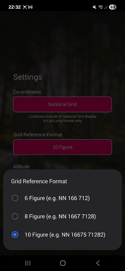
OSLocate can be set to show 10 figure grid refs, ie 1m accuracy. What its not very good at is giving me a decent elevation value, which is about 100m (vertical) adrift as I sit here. Granted I'm indoors right now, but it can be quite a way off outdoors too
I downloaded it this evening
Just tried to download on MrsEpic's samsung - playstore only shows OS maps, not os locate. Can only use OS Maps w a login. Seems a shame that such a useful app is not widely available
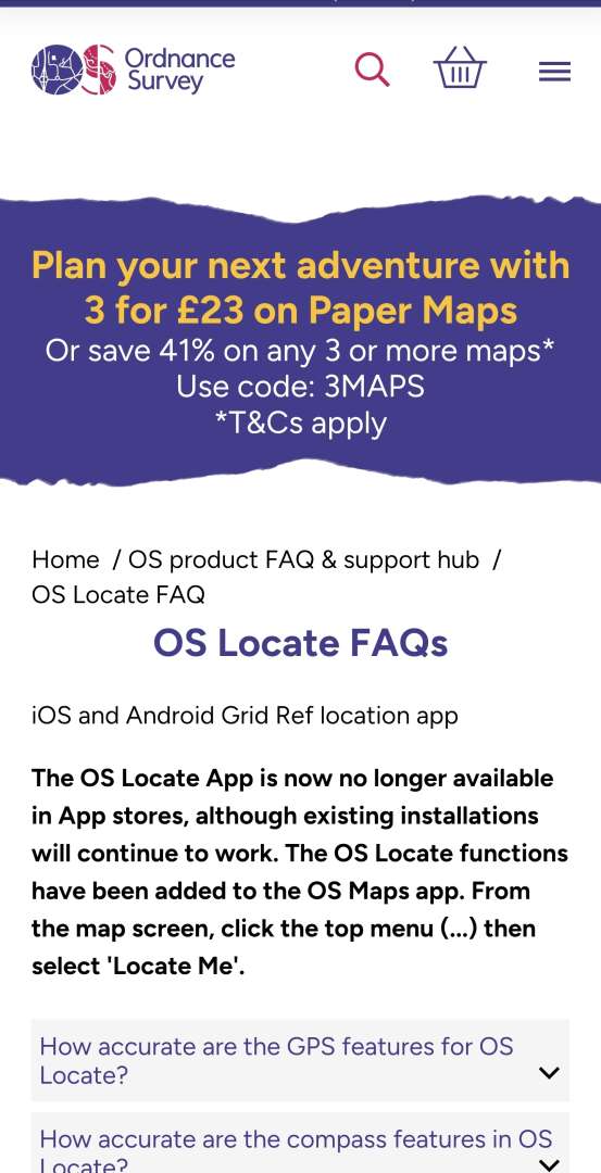
They stopped OS locate quite recently the app still works but they were supposed to not have in app stores any more.
I also have OS locate. Agree height not accurate around 50 or 60m out when I have checked against known height.
Great app for a one click to get grid ref for SOS or what I use it for checking my location on paper maps in mist etc
It was transferred over to my current phone from an old phone.
I managed to install OS Locate just before typing this. That was using my Pixel 8 and the standard Google Play Store. Perhaps it's because I'd installed it on another phone previously?
I've got UKGrid on mine which appears to do the same job, ie give grid ref and lat/long when you aren't sure. Doesn't do elevation though, but if you have a map you can see that easily e ought if you have your grid ref anyway
What advantage doesWTW have over OS grid refs?
More advertising budget?
What advantage does WTW have over OS grid refs?
Words are easier for a lot of people. They understand words cos they use them everyday whereas they don't understand grid refs or Morse code. I believe that was the thinking behind it.
I'm with the comments above though, I'm not a fan for the reasons given in the links.
More advertising budget?
Yep - those TV ads showing a helicopter appearing overhead a stranded surfer within a few seconds of him shouting 3 words into his phone seemed a touch optimistic!
doesn’t matter how good you are - it matters how good everyone else in the chain of typing your location in / copying it down is. I’ve no idea of W3W is actually better for error reduction than OSGB but OSGB is definitely not human error free.Personally I've never gotten a 6 figure grid ref wrong
have you ever searched for someone with just an OSGB ref? That’s a 10,000 m^2 area. About 1.5 full size football pitches. Easy enough if your casualty is highly visible on a flat bit of land. Not easy if the terrain is complex. In the urban environment even more difficult. Of course all gps based locations have a risk in complex terrain of being misplaced anyway but that problem applies equally to all grid ref systems.(easily big enough to get a search team to find you),
and it's fairly easy to give over a phone call in the wind, but of course it could be mistaken the same as anything
is fairly easy good enough for a distressed caller? We aren’t necessarily talking about “sensible” people who presents with NO012289 read it calmly and professionally as November-Oscar-One-Two-Two-Eight-Nine. Ask anyone who has worked in a call centre - the public are idiots.
I don’t know if it is or is not better - UK Coastguard use it with members of the public whilst using OSGB for land locations and Lat Lon for marine locations for their own assets. That suggests to me they find it useful when dealing with muppets., but maybe less so than a short combination of words that have many homonyms and are close by.
well that may be part of the issue - even the global one has three flavours of format, which can lead to errors for the inept. The “local” on has multiple levels of resolution but even a a six figure ref requires 8 words, and for similar precision to W3W you need 12 words. Is 12 opportunities for mishearing, mistyping, bad writing worse?And personally I just don't see the point, there's a perfectly usable system available. Two in fact, one local with massive historical use, and one worldwide with even more.
are we looking at that from a British perspective? Does every country have a great grid ref system? Lat Lon has a lot going for it but it’s verbose and typographical/transpositional errors MAY be less obvious.Why add to the mix (I know why, they wanted to make a system they could sell, simple).
if you ever need to print a very precise location (eg on an flyer) and have another user type it in to their device - it is without doubt better!I find that irritating, and the fact that it's not "better" in any way makes it even more irritating - we made a thing, it has more problems,
nobody forces ES to use it - if they have adopted it, it is probably because it actually offers them some advantages when dealing with the great unwashed.please all use it and now force the emergency services to use it also.
now if the OS Locate demise is true then it kind of blows out the water all the “there’s a great system readily available” arguments and the “a commercial company can stop anytime” worries - a state owned solution can just be wound down too!
I still don’t know why any ES is asking users on mobile phones for their location - it’s included automatically in the data sent to BT when you dial 999/112 from smartphones that are new enough to run W3W!
The whistle pattern is 6 blows with a minute between sets, and 3 blows for the response.
Thats off the printed panel of the emergency bag that Harrier do, who also do very good very and quality hiking/running poles.
I just bought a couple of their adjustable carbon poles that I carry in the rucksack for emergencies, carbon so they are light and adjustable as I might have to lend them to someone else so no point just getting my length.
What a useful thread
A few practical points
I usually ride alone. I always use strava beacon. This is included in the free version of Strava. My assumption is that if it all goes wrong i might well not have signal. But my wife will have my route upto the point where i lost signal. This should massively cut down the potential search area. “Find my phone” and other location sharing services do nothing if you have no signal
I don’t like what3words as a concept but i have the app on my phone. Because I’m not anti enough, to not have it, if I’m asked to use it in an emergency
My iPhone 14 should allow satellite text to the emergency services
I’m pretty strict about an extra layer
If it’s remote I’m take a battery pack. I’ll also make sure i have the OS map downloaded. FYI in pretty sure the OS map App is free and therefore the correct option for everyone’s who wants a grid reference. What you pay for is full topo mapping and the ability to export a gpx
i need to get a whistle
I agree that most of us are bullish about how fast things would go wrong if incapacitated and i include myself.
The hardest thing I’ve done on a bike was a 2 day gravel event in Wales. I ended up riding in a group of 4, 2 of the others were carrying a chunk more than me. I had a 3 litre frame bag and a 5 litre bar bag covering food, spares, tools and clothes. So i think just enough. Coming out is of a checkpoint some one said that i looked heavily laden. They were in shorts and a long sleeve top with a few bits in a jersey pocket. This was a route that went over to over 500m off road. The next day we were in cloud with horizontal rain in the middle of know where. I mean if you want to chance your arm in packable jacket that’s fine. But maybe don’t criticise those who have packed a few more layers. MR response time is in hours, that’s a lot if time cooling down
Talking of grid references. I have been using GridPoint GB for years (mainly for early accurate locations when letterboxing on Dartmoor). It’s a free app and gives you a 10 figure grid reference (1 m2) barely uses your battery. If doing anything that requires a map I usually carry an OS map for actual navigation, but for MTB I’m usually just following known trails or know where I am.
“Find my phone” and other location sharing services do nothing if you have no signal
I don’t like what3words as a concept but i have the app on my phone. Because I’m not anti enough, to not have it, if I’m asked to use it in an emergency
My phone says that Find My will still work even when switched off. Although HOW that works I've never looked into - not sure if it gives last known location of the device or actually has some sort of beacon that's permanently on...?
Same with W3W. I have it on my phone because it's a lot easier to have it if the shit hits the fan than to have to download it while standing on a hillside in the rain. I have the full subscription OS Maps app too, that's my default for actual nav and wayfinding when I'm out walking or riding.
Sorry to hear your original story jon, hope you recover quick. I am also a mainly solo mtb'er but usually just tell my other half where i'll be. She is linked into my garmin tracking, more so for when I do longer trips (multi day) etc than local loops. Carry a small whistle in a bag, I am intrested in these emergency shelters for the multi days, will have to invest in 1 of them. Good thread
have you ever searched for someone with just an OSGB ref? That’s a 10,000 m^2 area.
The OS Maps app and OS Locate both provide a 10 digit grid ref. That's a 1 metre square.
OS Locate is now bundled into OS Maps as a feature called "Locate Me". Including the free version of OS Maps I have.
Interestingly while they agree on location they are around 50m different on height. I am hoping Locate Me is height accurate. Anybody checked?
I am hoping Locate Me is height accurate. Anybody checked?
It's giving me a much more realistic altitude (292ft) than OS Locate is doing (455ft) right now. I suspect its taking that from the basemap raster, rather than trying to derive it from satellite data. Ive not compared the two whilst out and about in the open air yet, but my experience is that OS Locate is pretty poor at it generally. Its grid refs are bang on.
I thought of this thread when I came across an interview with Robin knox Johnston. Puts solitude in in perspective. Incidentally I don't know why I find long distance sailing so interesting when I have never done any sailing at all.
https://m.youtube.com/watch?v=7-sT17xm6XU