A group of us are staying nearby for a week of riding. We're looking for any information / recommended MTB routes that are NOT in trail centres in the Dumfries & Galloway area.
Looking for technical, hard riding, but not on man-made forestry routes. We're not looking for a guide! Any pointers much appreciated.
An ordnance survey is your friend here, but if you don't know the area you could get lost very quickly, or have a rubbish time, or both.
There are some great hills in the area, but surely a trail centre would be worth visiting for at least one day?
OS78 is the map you need for riding in the Lowther Hills. Maybe not very technical riding but depending on fitness it will be hard considering the rain recently.
Can start in Sanquhar and follow the Southern Upland way over to Wanlockhead.
[IMG] 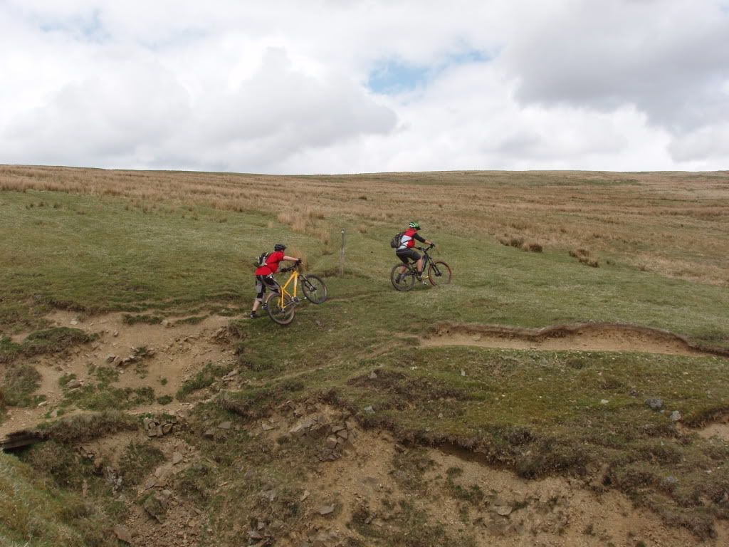 [/IMG]
Up to near the "golf ball" radar station. Before reaching the ball turn right at the end of the armco. Turn left down Enterkin Burn.
[IMG]  [/IMG]
Bit of a bimble back to Sanquhar or take in some of Drumlanrig. Follow track along the side of the river back up to Sanquhar, cross the A76 onto the Wanlockhead road and then turn left onto the Auchentaggart farm road and then across Auchentaggart moor and down into Sanquhar.
Might not be enough light now for that route unless you start early 😆
There is a good route out of Durideer over the hills to the Daer res, pick up the SupW to the Dalveen Pass Rd. Then turn left down the old Roman Rd back to Durisdeer. There is a track shown on the map as a dead end. This is a full track up now but a bit rough and bouldery and changes depending on how much and heavy the rain and snow has been. Cna be ridden by superfit peeps but for mere mortals like me it is a f8off push ❗
Do not take the 2nd track shown it really has turned into a nightmare push!!!
[IMG]  [/IMG]
Bit of SupW near the Daer;
[IMG]  [/IMG]
More stuff up in the Moffat hills;
Would do this as a desecnt next time. Exploring a route over to Same Y Ling that day.
[IMG]  [/IMG]
[IMG]  [/IMG]
Bodesbeck via SupW out of Moffat but a fair bit of tarmac back;
[IMG]  [/IMG]
I can read a map, so I'm not worried getting lost. Some tracks / paths / places are better for riding than others. I really looking for ideas of places/ tracks/paths to ride.
Thanks
Edit. Trekster- Thanks. Great info.
A lot of the "tracks" can look very similar to sheep/cattle tracks and as Gary says it IS very easy to go astray 😳 Unfortunately I have built quite a reputation for doing so in and around those hills amongst my riding buddies. Never actually been proper "lost"
btw there are a good few "local" options in and around Mabie;
[IMG]  [/IMG]
and Dalbeattie
[IMG]  [/IMG]
[IMG] 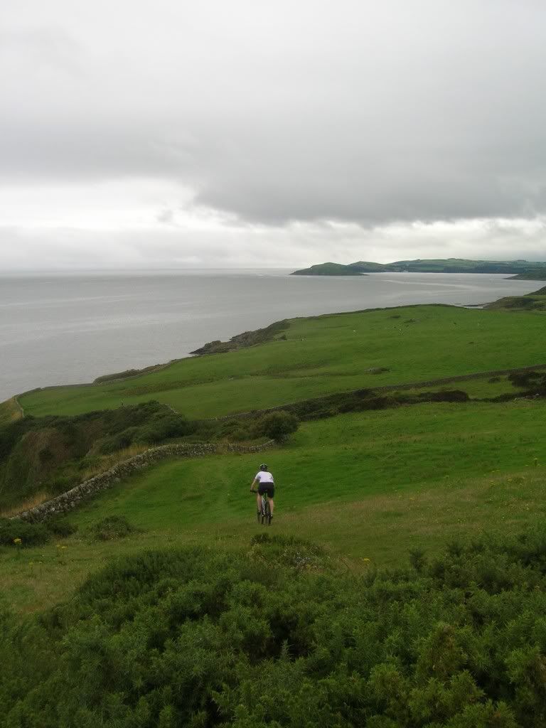 [/IMG]
+ a bit of hike`a bike up onto Little Queensberry from Ae.
if the weather is rough;
Trekster, that second photo looks like you are kite surfing which could be the answer to the joys of riding up hill 🙂
nearest thing to an uplift for bikers in scotland 😉
I did a big route around Wanlockhead, starting from Drumlanrig castle. Nothing particularly technical, but a cracking day out. The singletrack down Enterkin Burn is particularly tasty in a not-much-room-for-error kind of way
Really interested in the 'local' options around Mabie . Been studying the Map around there - any pointers?
Cheers.
The "monument" ride we start at Mabie, head over to Troston via a 😉 ttrail that come out near the loch. You could add some knarr by going via Vaders Layer and do the boardwalk stuff. Once into Troston keep right at the first Y junction. This is a bit of forest double track that then degenerates into a bit of muddy singletrack. When you reach another forest road(passing through/over a dyke)turn right onto this forest road.
You are now in Shambellie Wood
After a bit of a downhill there are some forwarder tracks going up to the right. Take this and keep left onto a grassy track. Follow this straight ahead.Bit wet here`n there. At a T(left)junction you keep going straight on, again gets wet. Just after that wet bit there is a turning to the right which is very easily missed just after a "drop". Take this, can be vague in places.
When you come to the Beeswing/New Abbey road there are 2 options;
1-Turn right and then after a mile or so turn left onto the Solway Fisheries track. Take the forest road which is straight on through gate and keep left uphill. Miss the first junction to the right and go straight ahead and then right uphill and follow this road to the monument. Vague tracks up to the monument. The descent in the pic above is to the left of the monument and again is a bit vague. Halfway down when you cross a forwarder track there are 2 tracks going straight ahead(down)you must keep to the left one. When you come to a burn turn right and head towards New Abbey. Turn left at the old mill and over the bridge. Here you can turn left and retrace your tracks via Shambellie/Troston back to Mabie. An easier way is to go straight on over the bridge and turn left onto the track signposted Gallery. Go head through gate where there is a wood yard(council training)and follow this road back to the hole in the dyke you passed through earlier.
2- Go into New Abbey and turn right onto the road taking you past the sawmill. Carry along what becomes a farm road. Not easy to find but there is a track to the left which takes you up to the monument(the one you will descend)When you come to a burn cross it and follow the track to a forest road. The track can be wet/boggy in places. Upon reaching forest road turn left uphill and follow to monument, turning left near top of hill.
Return as per 1
There are a few other "local" trails in Mabie but they are not easily found if you are not being observant, good couple of hrs play time off the main trails 😉
That stuff is not on OS78 btw
Enjoy 😆
Mail me if you want some grid refs
bump
ouch 😉
Hi bump 🙂
There is not much really technical riding around the dumfries area- what there is is a lot of very nice scenery that you can get bike access to as Trekster has shown you. Some of the best natural stuff can be found around the trail centres but off the signposted routes, kirroughtree and mabie have some hidden gems with more tefhnical riding than you would find on your waymarked routes. As trekster. Said though, they are hard to find and harder to give directions to. Part of their joy is seeking them out, but always good to know where to start- lot of locals still dont know what is available.
Been told there is a good descent off merrick in the galloway hills but I think it is more a fast descent than technical, havnt ridden it myself. Depending on where you are staying perhaps a day trip to the northern lakes (skiddaw or ullswater) would give good natural riding within 90ish minutes of dumfries.
I know you weren't looking for a guide, I am riding mabie in the morning and coukd show you the bits i know- I cant give you much help in your search for other natural routes, but i could show you some of the better trails at one of the trail centres if you are struggling for ideas?
