Anyone been up and down there recently. Look to do the climb to MCB then over to Sgor Gaoith then decening via Carn Ban Mor. Wondering want the path conditions are like.
Mullach Chlach a Bhlair
Ive some cough mixture that will clear that right up...
Waterbars for max pleasure, not quite the descent it used to be, you want to be descending off Sgor Gaoith.
Agree with Fergal.
Drop North off Sgor Gaoith to Creag Follais then take the zig zags down form the weather station.
If you struggled down Ben Lomond, then I'd maybe think twice about Sgor Gaoith tbh.
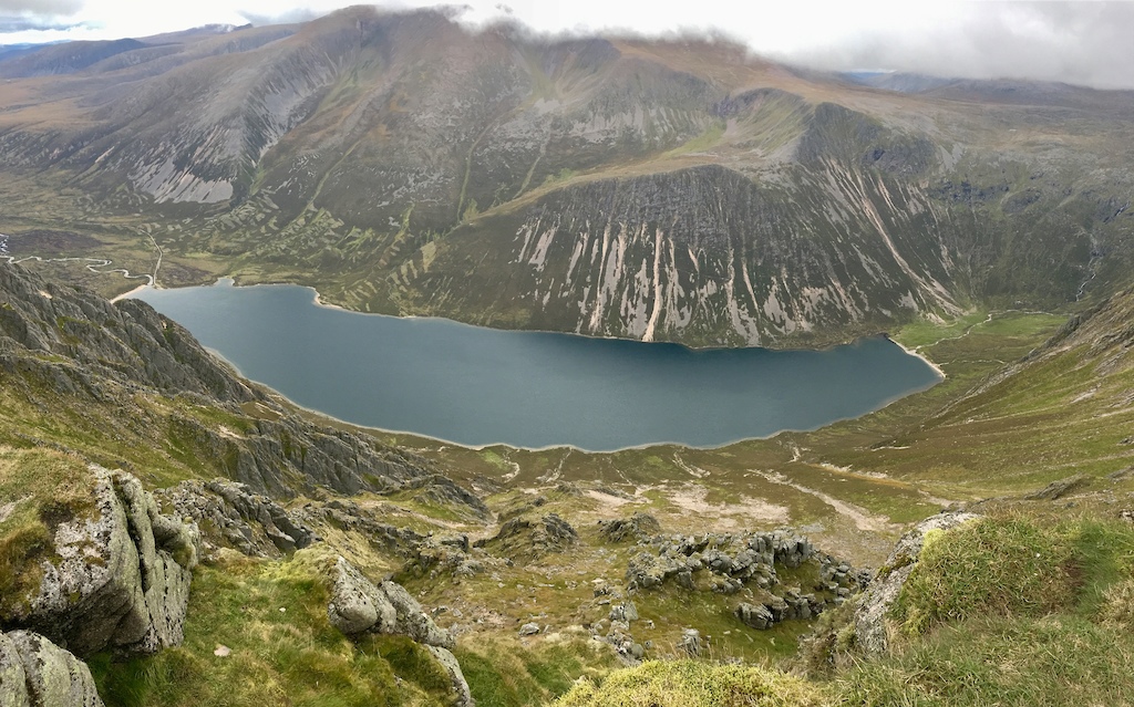
There are three singletrack routes off SG back into Glen Feshie. In my view, the Stalkers' Path descent west from the coll between SG & CBM is the better introduction to Cairngorm descents, if you are unfamiliar with this territory. I'd avoid the old descent straight off CBM as it has been over sanitised into a red grit motorway with water bars. The northern route via Follais & the weather station to the zig-zags is a bit more full on and is not to everyone's tastes. It's also quite overgrown this year once you enter the scrub pinewood so will ride better once either the bracken drops in October or someone goes up with a wee saw and takes back a few of the smaller trees.
Finding the start of that recommended middle trail is not difficult. From the Sgorr Gaoith cairn, return southwards on the main trail back to the coll between the summits, then turn due west (off-piste) from the lowest point of that saddle. After just about 200m there is the most bizarre patch of brightly coloured mosses & lichens; as you reach it, look ahead and to your right and you'll see the trail. Follow all the way back down into the forest and at about 800m+ vertical, this is one of the longest continuous trail descents anywhere in the UK..
have you got a strava or GPX of it. I get lost oh so easily lol
Nope. Get a map & compass; the batteries don't run out. It's not on Trailforks either.
Nope. Get a map & compass; the batteries don’t run out.
Correct answer 🙂
Looking at streetmap there's a track marked that ends due west of Sgor Gaoith, does this actually extend on the ground further south east to the point you mention being west of the col somewhere on the edge of Coire Ruadh?
does it follow Allt Ruadh and bring you out up from the Glen Feshie hostel?
If you use a site that lets you plan routes using both os maps and aerial photographs then you should be able to create your own gpx track from highlandman's instructions. Never ridden it myself, but took a look at the area out of interest and it was quite easy to see the track on the aerial images (just an extension of the one that seems to be a dead end on the map).
Not that I'm denying that it's a good idea to be able to navigate using a map and compass. I think I probably still can, but since I always carry at least two gps devices (and usually 3) on a ride I'm not sure I'll ever need to.
but since I always carry at least two gps devices (and usually 3) on a ride I’m not sure I’ll ever need to.
Until they switch off the satellites during WW3. Now how will you find your way home during a nuclear whiteout?
I think I might just stay up there in that case 🙂
I do do occasionally get the map and compass out and try to refresh the old skills. But it feels increasingly pointless.
I'm guessing the due West turn off point that highlandman refers to is at or around grid ref.NN897 978..?
Looks pretty hairy depending on how it actually contours around / down the mountain ..!
Great local knowledge though ..I've only ever done the easy stuff along the valley floor and then over the other side on some singletrack in the forest below Creag na Sroine which was excellent at the time back in 2011( ?) ..but who knows we might get back there one day ..
Did the bridge ever get re-built at Carnachuin..the guide book had no mention that it had been washed away and we had to wade across with water up to our Nicky nacky noos ..made things a bit more interesting ..
Look forward to your ride report & video Ross..
GR from Hodgynd shown above is correct Yes, as a couple of folk have suggested, the trail extends much higher up the coire than the OS maps suggest, even the 25k. It is a bit steep at first off the col at the 1012m spot height, with one or two rock features to cross but nothing too scary and is wholly rideable from the top with both wheels on the ground. One of the best things about this trail is that it changes character several times on the way down; open mountain at the top by the Sgorr Gaoith cairn with stunning views, then fast & rocky before twisting around onto the path from the lichen patch, with a descending contour feel. Next comes a wide ridge top with tundra and a fainter path, followed by steepening beside the cairn into a heathery, lumpy hillside. Further down and across the first of 3 burns, you encounter a section of old, washed out but built trail that suddenly mutates into modernised, before narrowing and diving into the forest... Do it on a day with good visibility. The view east from the plateau across to Cairn Toul & Braeriach is quite special, while out west you can see all the way to Nevis and Knoydart. The northernmost descent is a step up in character so I'd always suggest doing this Stalker's path option first, then come back to do the Zig-Zag one later.
As far as I'm aware, that bridge is still missing, making access to the ruigh aitceachain bothy more awkward.
Ideal, heading up to Aviemore in the October break, bit of walking with the family, I'll recce this one on the way up to Sgor Gaoith.
Cheers HM.
Mapped it out. Its about an 18 mile circular ride. I may have a sleep before heading back down the road lol.
Thanks for the help and trail suggestion HM
Brilliant info HM ..and noted to memory for what will now have to be a return visit ..
Many thanks .
May one suggest the lochan nam bo descent? The bottom section through the trees is a pure heather bash but the zig zags are very much still there. I walked up it with the bike at Easter. You could feel the old trail through the heather and the fat bike cleaved through it. We had to turn back due to the snow higher up.
Has anyone else ridden it?
Cheers
Sanny
Not familiar with that one Sanny but have just looked at it on the OS 25k. Could be interesting, although I suspect quite a bit of off-piste along the way from MCB summit down to the 737m spot height. Defo one for the fat bike then.. maybe try for that before the year is out, if time allows.
That was the best decent I've ever done. Shame it had to end. Thanks for the recommendation
Wot ...no video ?
Not yet.
Look forward to it ..
The munros book describes that path as boggy in places; been a dry summer, did it look like it might normally be boggy?