its been a while since i rode my bike any great distance - possibly my arran tour or my shetland - back home ride which were both at least 3 years ago.....
lifes just got in the way - i mean its not like ive been slacking - a brief recap of the last 4 years would be - bought a house , rewired,replumbed,redecorated said house , built a land rover from the ground up , got married.
Feeling hungry for an adventure but aware that im not as fit as i should be i made excuses for not riding the cairngorm loop or Ht 550 with my mates when asked but conscious i needed to do something about it....
Hello scotrail.com - £14.60 for the train from aberdeen to kyle of lochalsh on the 6.14 on monday and there bike space. Yes please. and with that a plan was hatched to ride back to stonehaven via the interesting/high routes.
[img]  [/img]
[img]  [/img]
train journey views
[img]  [/img]
looking out to skye.
[img]  [/img]
looking down into kylerhea
[img]  [/img]
off the ferry - the C2C starts now.
[img]  [/img]
glenelg bay.
[img] 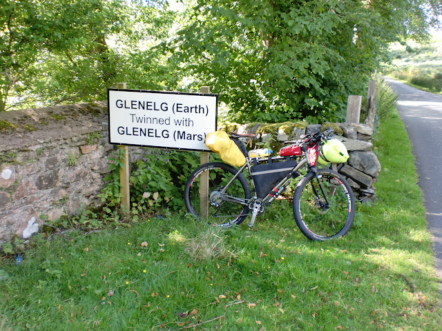 [/img]
perhaps someone can shed light on this sign ?
[img] 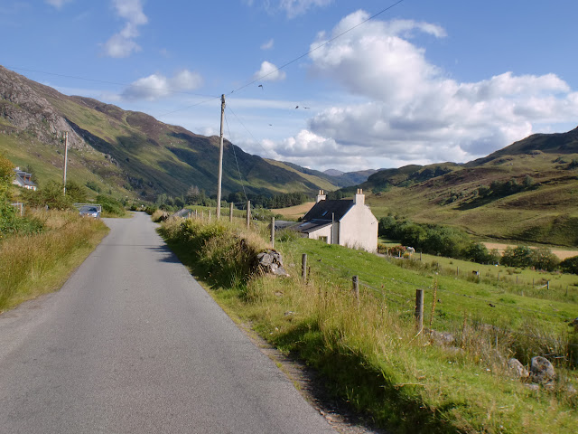 [/img]
i guess its uphill from here - mam ratagan climb from the west side.
[img]  [/img]
looking out at the 5 sisters from the mam ratagan view point. heading for morvich which is round in that dark shadow between the hills.
[img]  [/img]
the last shop before entering glen afric.... slim pickings to say the least - i ended up with a pasta in sauce packet for supper and a tin of ambrosia rice pud for breakfast -
[img]  [/img]
entering the mountains on the afric kintail way. This was a good going land rover track up till
[img]  [/img]
from here it was a ride some , push some , ride some , push some. But that was no surprise having looked at the os map - goes from double track to single track and also starts to cross contour lines at an alarming rate.
[img]  [/img]
some of the riding bits .....
[img]  [/img]
looking back from where i came.
[img]  [/img]
[img]  [/img]
camban bothy. Nice gaff but i wasnt ready to stop here - was only 17.30 and the midges hadnt come out - there was still a wind as we were on top of the pass pretty much.
[img]  [/img]
did another 3km down the hill and came across alltbeithe - stopped here to consider on the map how far down the hill till the next suitable spot and it was then the MIDGES came in in great clouds. I knew glen afric was famous for them but did not realise that this late in the season they would be this bad. My tollerance for midges being a scotsman is quite high but these were unbearable. Hannah the hostel warden had been watching out the window timing how long till i came in looking for a room as she knew the midges were hungry today. its a very nice hostel and i found the self sustainaning side of it very interesting. Wind and solar with a back boiler for the shower.
perhaps someone can shed light on this sign ?
The Mars rover traveled up a valley on Mars and then turned around and returned the same way. They named the valley Glenelg because it is a palindrome.
day 2
[img]  [/img]
low cloud leaving the yha.
[img]  [/img]
[img]  [/img]
not the first to join up these two fire roads it seems. near plodda falls
[img] 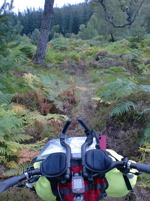 [/img]
[img]  [/img]
plodda falls them selves.
[img]  [/img]
climbing over to glen morriston
[img]  [/img]
redburn cafe - 2km from the bottom of the trail - just happened to see a cafe open sign as i looked left onto the road and was happy not to have to go to fort augustus for food as it was 13:00 and id had a granola bar and a tin of rice pud at 7am....
[img] 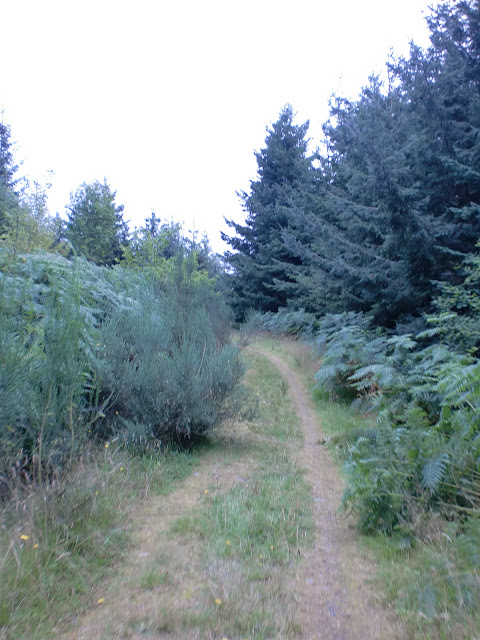 [/img]
the climb up the military road from torgyle bridge was actually very good and a welcome change to the pylon construction tracks i had been riding over the previous pass.
[img] 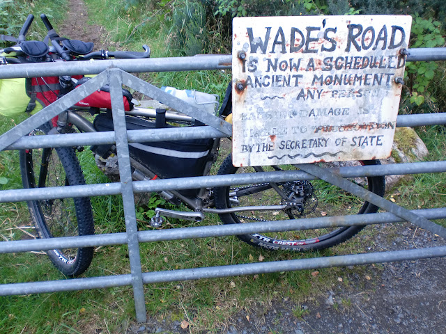 [/img]
[img]  [/img]
[img]  [/img]
climbing corrieyarrick in the dark- this was a bit disorientating as my maps showed clearly i should be along side the pylons - i wasnt. There was a road and pylons to my right....should i be over there..... then it dawned on me. Those are not the same pylons that were here last time i rode this trail - those are new pylons and a new construction track - im on the right trail 😀
[img]  [/img]
home for the night. all to my self.
[img] 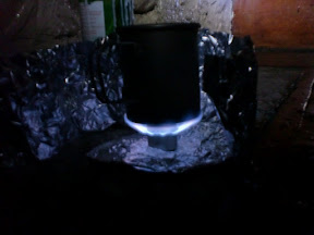 [/img]
it is possible to make supernoodles in a 400ml mug on a barebones 8gram stove using only 1 fill of fuel 😀
Looks awesome. Did you record the ride so i can take a look at the route?
i did ,I have got the GPS trace plotted on OS maps. bare with me , i think the internet at melgarve bothy was better than mine here .... i seem to stick after uploading 25pics at a time - but i blame the wifes laptop for that more than the internet.....piece of crap.
Anyway that was the end of day 2.
stunning photos 🙂 .... makes me want to go do an epic now !
Brilliant write up. Thanks
Most of that looks familiar from HT550. Did you have a look in the 'hut' at the top of the 'pylons' road over to G Morriston? With a quick tidy up it's an overnight option (though not the prettiest....)
Many thanks. Interested in the route too as planning something big for next year when (hopefully) recovered but don't use GPS -I'm a confirmed paper map user, so a rough description would be great, as and when.
awsome
Excellent stuff!
i did it all with os maps ononeorange - although in hindsight if id had more time to plan it i would have made up laminated route cards as i needed 10 os maps for this route due to zig zagging across sheets .
yes i did refer to the ht550 route for most of the first couple of days with a couple of deviations to what i thought were more interesting routes - endless pylon construction trails was getting old 😀
later on i use the cairngorm loop for inspiration
and then i just use trails i know from being local for the last section.
i did look in that generator hut - theres one on the corrieyarrick too - its a solid roof but frankly id rather be under my tarp in all but absolute pishing rain. i was determined to make melgarve that night - took me till 10pm to get there, Descending corrieyarrick with a USE joystick was actually quite fine. wasnt looking forward to it mind !
ive managed to get 6 photos from day 3 uploaded so far :S
Cracking stuff. Well done.
*likes*
Glen Affric in the broad sunshine was one of the most glorious rides I've ever had the pleasure of.
Day 3
[img]  [/img]
arrived in the dark the previous night so it was good to see it in the sun - later start than i hoped having spoke to the game keeper for a fair bit in the morning over another breakfast of ambrosia rice pud.
[img]  [/img]
hitting the road
[img]  [/img]
glenshero lodge to kinloch laggan trail
[img]  [/img]
down to kinloch laggan
[img]  [/img]
[img]  [/img]
from kinloch laggan i couldnt find a way through onto the river pattick trail that wasnt absolutely closed due to forrestry (and i mean closed in such a way that without deliberately breaking and entering by cutting fences i couldnt get through with signs etc) so i went to laggan wolftrax for lunch - which was a disapointment compared to the carruthers hardy fare - looking forward to a beans on toast with toast the size of doorsteps....got a "burger"
I spoke to some folk who seemed to think i could get to dalwhinnie across the tops from the top of the old red route the maps said no but even so i had a look- you can - i even went bush hacking for a bit incase it opened back up into a trail - it doesnt.
[img] [/img]
one of the trails i wanted - the old drove road to dalwhinnie. anyone ridden that when its open ?
following scotroutes previous advice i took down the red route at laggan - and peeled off at the closed section right down the carpark at the other end of strathmashie - the one next to the dalwhinnie road turn off and climbed my way up towards cathouse and turned left to glentrium.
[img]  [/img]
where old pylons go to die.... bringing them in by helicopter and claw.
[img]  [/img]
its the center of scotland so the sign proclaims.... didnt know that was there - its literally a single track unclassified road
[img]  [/img]
again thanks to scotroutes i took the trail from just north of etteridge up through phones and back onto the military road to ruthven, which id been
warned can be quite boggy at times but it wasnt so bad on wednesday.
[img]  [/img]
if you want to go to ruthven - dont miss this turn ! - i did the first time.
[img]  [/img]
had a very short traverse up the side of the A9 as the trail spits you out on the A9 and you can either risk crossing the a9(was rush hour) so i just rode up the verge for the 300m before throwing my bike over the fence and going down the bank to the trail again up to ruthven steading looking out at the barracks.
[img] [/img]
Turned right just after the barracks and crossed into glenfeshie which i had all to my self for a change- usually meet quite a few folk in there although usually mid summer.
took a slight wrong turn - was supposed to end up at loch an eilean - thought i could descend to the road on some singletrack then climb back via the fire road on the map - turned out that fire road went straight into a deer farm which was all locked up due to a deer rut ongoing.bugger- into aviemore for fish , chips and tradewinds.
day 4 saw heading back out the old logging trail past loch morlich
[img]  [/img]
[img]  [/img]
[img]  [/img]
a ridable stream crossing.
[img]  [/img]
up ryvoan bothy - stuck my head in , looks tidy. Although as usual theres always some pricks who cant pack in/pack out and left a pile of tesco sandwich boxes in the porch! I had no spare capacity either to take your junk out who ever you are !
[img]  [/img]
not a ridable river crossing .... was knee deep on thursday in the middle. Shoes and socks off for this one - i still had dry mt91s at this point.
[img]  [/img]
[img]  [/img]
popping through the gap to glen brown and onwards to tomintoul for the old firehouse cafe lunch break.
[img]  [/img]
climbing up past a ruin - on the descent from here i got my only puncture of the trip - a sodding rim dinger on a waterbar i misjudged. wouldnt seal. Was right on the bead so out with the valve and in with a tube - and i rained - and the midges came in - and in my haste broke my own rule about refitting tires by hand only because schwalbe on Stans is a tight fit and was covered in stans goop.
out with that tube - washed my tire in the burn and refitted another tube - tire went on the rim no sweat this time.
[img]  [/img]
Hitting the road to tomintoul where the driver of the highland school bus just about wiped me and a CRV coming the other way out as he overtook me on a blind corner cut into the side of the hill - prick.
quick stop for food and restock before heading to braemar.
[img]  [/img]
[img]  [/img]
heading up glen bulig
[img]  [/img]
at this point i put the camera away due to pishing rain so less photos.
[img]  [/img]
the rain chasing me down the glen.
into braemar for night 4. The audax legend that is the hungry highlander fish and chip shop (home of the biggest fish suppers i ever saw only to be eaten during 300k audaxes) is now an indian..... disapointment. So i went to the co-op bought a olive loaf , a pack of smoked ham , a pack of grated cheese ,box of salad and a jar of horseraddish sauce.... the dutch woman in the hostel kitchen just looked bemused when i cut the loaf in half length ways and made a very big sandwich 😀
final day - not much as i was on home known ground ALTHOUGH i should be clear i didnt actually make stonehaven.
I got to the phonebox in glenesk at 19:00 with no food and i knew from previous experiance i needed 4 hours to get over glen dye and cairn kerloch/drumtochty/fetteresso so made the decision to Time trial against the sun to montrose as per the standard C2C finish and made it by 20:30 where the berlingo was waiting for me 😀
[img]  [/img]
over the bridge at inver heading for glen gelder.
[img]  [/img]
looking up glen gelder to the saddle over to loch Muick
My camera battery died then - but the rest of the route went - down glen muick to ballater for coffee and lunch in the bothy(FYI the co-ops closed down now) before climbing over the cairn leuchan track down to mount keen - a shove up mount keen before descending into glen esk and TTing to montrose.
[img]  [/img]
[img]  [/img]
[img]  [/img]
[img]  [/img]
[img]  [/img]
[img]  [/img]
[img] 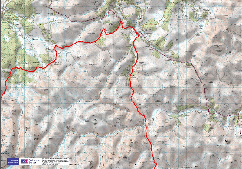 [/img]
[img]  [/img]
and for the rest i just followed the road down to the edzell road - turned left then right and went past the airforce base to northwaterbridge onto hillside and down to montrose beach.
cheers to the guys from the HT550/Cairngorm loop/Scotroutes for the inspiration and help with routes and to Househusband of this parish for putting my trace on an OS map.
Wonderful Sunday reading and congratulations 🙂
I assume you are aware of OS select maps where you can select your own area and have them printed, great for when route overlaps standard maps. Also OS Map online people subscription gives you ability to print your own sheets plus phone app which can cache maps and at the touch of a button show where you are.
Bookmarked. Good work. Ta.
Yep how ever. My phone was off for almost the entire trip and the whole thing was planned in less than a week so no time to make maps...... And in that week i changed my bike from singlespeed to gears , got all my luggage sorted (cheers alpkit- good to see you have finally strayed away from trying to be the cheapest to actually providing good usable kit for reasonable prices as oppose to just cheap one trip bin fodder previous experiances with them have been less than satisfactory) and then planned a route.
Then theres the fact i made a few chunks of the route up on the hoof over a cowboy coffee in the morning 🙂 i knew where i had to get to and i had a rough idea of some trails i wanted to include so just joined the dots on the map....worked out mostly,
Was just thinking the same. Has got my brain whirring for next year. Thanks for sharing.Wonderful Sunday reading
This forum needs a like button. Genuinely inspiring. Cheers
Inspiring indeed. I need a print of one of those OS map tracks on my garage to get me out riding properly
Love this - thanks for posting & well you know, riding it! Like! 😀
Wow, that looks excellent. Thanks for posting up.
TR, the Co-op has relocated both stores into a new location, namely the old bus depot opposite the church green.
Epic ride btw.
Thanks for the credit for the mapping, Terry - happy to help.
Jambalaya; OS has only just caught up with the other mapping that has been out there for years - I just happen to use Quo as I've had it for years and have all of Scotland at 50k.
If anyone's interested here's a link to[url= https://drive.google.com/file/d/0B0Oom9k3xSpCWnBpdHg5S2hxNVk/view?usp=sharing ] trail_rat's GPS log[/url].
A cracking read from which I may gain the inspiration to do a big ride
Amazing!
Not local i assume you mean ballater ? In hindsight i should have popped in and asked dan where it went , given theres not many other options its hard to imagine they would have upped sticks and left.
In fort augustus the closed cost cutter meant raiding the garage - which was actuall? quite well stocked if a bit pricy
These photos have just cost me a heap of money ......- measuring up mrs t-r bike for luggage now :/ she wants to come on the cairngorm loop tour we have planned.....
Yeah, sorry, should've been clearer. Not surprising you missed it though as the signage is about 30 feet off the ground.
The bothy is an acceptable substitute - they do some good coffee in there . Its often a haunt on road rides 🙂 shame it was ( as it often is) busy to get a seat 🙁 ( a good thing for them no less)
Brilliant sir, thank you - getting ideas now about my big ride next year (hopefully).
And thanks for that mapping at the end - appreciated.
I normally argue with you trail_rat but that sounds like a good trip 🙂
Btw, in that shot up there of some glen where you said you put the camera away due to rain - is that a rocket taking off in the middle of the picture?
Although it never dawned on me at the time christopher, micheal and mathew mayo were the 3 folk killed in bad conditions with in adaquate equipment for the weather in 93
I remember reading about them in cairngorm john.
Good to see the bothy dedicated to them in such great shape.
Fantastic pics, thanks for sharing. Makes me want to do an epic long distance adventure!
Glenelg is also the name of an area in Gale Crater on Mars, hence the sign 🙂
great report and a ace ride, one day ....................... well done 🙂
Enjoyed that read, cheers.
flippin ace t_r.
thanks for the inspiration for me to do same (once get family stuff sorted out).
Did you carry a rucksack/pack as well? By the time I've looked out a tent + gear there's not a lot of spare space 🙂
Great report.
What bike did you ride it on? It looks like a Ti Pipedream I once had with the paragon style dropouts.
On the bars i had a 3 season sleeping bag ( time of year - normally i carry a bag the size of a can of beer and can get my whole sleeping system out front) and my bivvy bag.
In the frame bag i had my stove , cup , spork and meth, my maps ,rig 1.0 tarp and my neoair sleeping pad
Top tube bag got snack food and my midge net and ti sticks tent pegs.
Just the one bottle carried on the top tube.
In the rear bag i had 1 spare set of cycling gear, my skins for sleeping , a pair of warm gloves , my down vest. And a pair of columbia packable shorts for casual.
On my back i had a camelback blowfish. I put my waterproof in it and my electronics - i had a 7800mah charging brick , and cables for both phones and my garmin. My multitool , tubes and leatherman wave, this let the bag close on its fully compressed setting. I then just expanded it to carry food after food stops.
Bugger tents to much weight 🙂 i aimed for bothys first , yha's second . The bivvy was the last resort. Only came close to using it up on corrieyarrick.
Bike is a ragley td-1 with triple butted project 2s
Nice but tri bars pleasssssse remove them aerorat 🙂
Eh-no. My fingers are shot and cant take long distances in one position anymore, ruined them at mayhem one year.
Also do a good job of holding my map in place 🙂
Funnily enough I also had a td-1 for a short while. I couldn't stay on the damn thing so replaced it with the Pipedream. Still regret selling the Sirius Ti.
