- This topic has 31 replies, 20 voices, and was last updated 7 years ago by rocketman.
-
Walking Cadair Idris
-
fathomerFull MemberPosted 7 years ago
Me and the wife have a few days off at the weekend and are thinking of heading to North Wales with the tent. Providing the weathers good, we’re planning on walking Cadair Idris.
From a bit of internet research, up and down the Minffordd path looks to be the best and easiest way?
Am I right in this assumption and how easy is navigation? We don’t have an OS for the area and probably won’t get one before leaving. I do have the OS maps on my Edge 800 so could use these at a push.
jambalayaFree MemberPosted 7 years agoA few thoughts 😉
Nav pretty easy
Buy a map
Buy OSMaps subscription (£20-ish) and download app
Create route on garmin base camp or bikehike and load that into your GarminMinford path has some scrambly stuff at top, its not the easiest way up at all. Thats via Bridleway from tynn-y-doll, car park just before and start along by the river. Will drop you an email
qwertyFree MemberPosted 7 years agoMy son (9yrs) & I did it last summer.
Personally i think you need a weather window for mountains, the more experienced you are the more adverse the conditions you can experience, we opted for a perfect day of sunshine, no wind, with excellent visability. The views from the top were fantastic.
I wouldn’t go up any mountain without the relevant OS 1:25000 map, regardless of any electrickery i might be carrying. Same for decent walking boots and layers & waterproofs.
This is the horseshoe route we did: http://www.trekkingbritain.com/cadairidristheminfforddpath.htm .
Cwmrhwyddfor Farm campsite is ideally suited for the above walk, no car needed.
 [/url]IMAG2759 by martinddd, on Flickr[/img]
 [/url]Cader Idris summit behind Tom by martinddd, on Flickr[/img]
 [/url]IMAG2765 by martinddd, on Flickr[/img]
 [/url]Cader Idris summit by martinddd, on Flickr[/img]Garry_LagerFull MemberPosted 7 years ago
That’s a beautiful walk and navigation would be easy in clear weather. Be fine taking the garmin just to have the map on hand.
fathomerFull MemberPosted 7 years agojam bo – Member
I can see the MRT press release now 😉Lol, I’ve been up on the bike via the Pony Path and that was pretty easy enough navigation.
@jambalaya – Usually I would buy a map but this is a bit spur of the moment and don’t think I’ll get one in time. I’ll look out for a mail, cheers 🙂
@qwerty – Completly agrees, have waterproofs, boots etc. just as above getting a map might prove troublesome. We’ll be camping near Coedy as also taking the bikes.
ElShalimoFull MemberPosted 7 years agofathomer – Member
Usually I would buy a map but this is a bit spur of the moment and don’t think I’ll get one in time. I’ll look out for a mail, cheers– rubbish excuse, just leave home 5 minutes early and just buy one in a local shop. £8 could be the difference between a nice day out and navigation mistake leading to an accident etc etc.
It’s a lovely mountain and a fab day out, so have a great time!
fathomerFull MemberPosted 7 years agoElShalimo – Member
– rubbish excuse, just leave home 5 minutes early and just buy one in a local shop. £8 could be the difference between a nice day out and navigation mistake leading to an accident etc etc.To be fair your probably right, there must be an outdoors type place in Dolgellau.
km79Free MemberPosted 7 years agohttp://dash4it.co.uk/ordnance-survey-maps.html
Order your map here, much cheapness and free quick postage straight to your letterbox. No excuses for not having a map.
obviousthrowawayFree MemberPosted 7 years agoLast time we did it a couple of mates and I jumped into the lake naked on our way down. Bracing but memorable!
matt_outandaboutFull MemberPosted 7 years agoI’ve been up on the bike via the Pony Path and
that was pretty easy enough navigationin the reasonably clear visibility I had, this maybe dramatically different should the weather close down or I make a mistake.FTFY
dragonFree MemberPosted 7 years agoThere is an outdoor shop right in the middle of Dolgellau that will sell you a map, probably can pick one up in the local newsagents also.
While you there I’d also recommend the Precipice Walk, not as long or as hard, but some stunning views.
fathomerFull MemberPosted 7 years ago@matt_outandabout I fully appreciate the difficulties that may occur if the weather comes in etc. We won’t be going up if the weathers bad or may become bad. I also fully appreciate that it can be very unexpected, hence we always carry compass, waterproofs etc. etc.
@rwamartin – very kind of you, much appreciated.
SpudFull MemberPosted 7 years agoThe last time I did it, started off lovely and clear and when on the top cloud with less than 20m vis and needing the map and compass to get down. It’s a great walk as is the Precipice. Enjoy!
nosediveFree MemberPosted 7 years agoI’m pretty sure that the petrol station just outside dolgellau sells maps
jambalayaFree MemberPosted 7 years ago^^^ local petrol stations, newsagents etc will all have maps
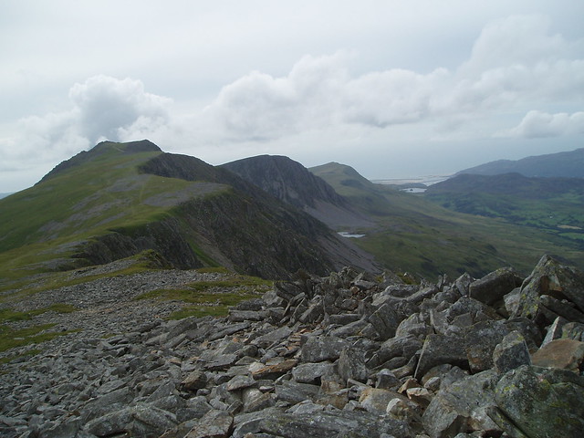
Steve_BFull MemberPosted 7 years agoBrilliant hill walk. We also did the horseshoe route as the hike out from the summit overlooking the estuary was the highlight for me. The paths esp past the summit are vague so if you lost visibility navigation and safe exit would not be good.
 [url=https://flic.kr/p/6Yv3AA]Cadair Idris[/url] by steverb_11, on Flickr
Its not a hill I would be on without a map and many shops/cafes/visitor centres in the area will sell them. I find the garmin a bit of a pain for hill walking – my wife takes great pleasure in finding the route twice as quickly with map and compass. If you don’t get one before you go there are lots of online sites were you can access OS mapping and (screen)print off enough for your route. If you register for Walkhighlands you can get 1:50 openstreetmapping and 1:25k OSmapping.
matt_outandaboutFull MemberPosted 7 years ago@fathomer – 😀
As the others have said, a great day out and lovely for what many see as a ‘small hill’…. Been up there a good few dozen times when I worked at the outdoor centre locally – cracking views and lovely steepness to lose yourself in.
anjsFree MemberPosted 7 years agoI would also take a compass and know how to use it when the weather comes down
parkesieFree MemberPosted 7 years agoDid it in snow for new year a few years ago. Amazing day out. For a beginner look for a good weather window and take a map and compass. Pretty hard to get lost untill the weather closes in.
fathomerFull MemberPosted 7 years agoThanks everyone.
The forecast, touch wood, is looking pretty decent for Friday and the visitors centre at CyB sell maps, so all good! Really looking forward to it.
rascalFree MemberPosted 7 years agoSam – good choice! Love that hill.
Pony path for the bike, Minffordd for a cracking walk – that’s what I’ve done anyway.
There’s an outdoor shop in Dolgellau too which will have maps etc.
Do both in the same weekend – now that would be good!fathomerFull MemberPosted 7 years agoWayne, not sure the Mrs would fancy it on her bike to be honest 😀
SpudFull MemberPosted 7 years agoLeave some sun over there, we’re off for 6 days on the Wednesday!
rascalFree MemberPosted 7 years agoThen do the gentlemanly thing…give her your Transition and ride her BSO 😉
You sorted for digs? Dol can be a bit weird if you’re pubbing it there of a night out – well it used to be anyway.anotherdeadheroFree MemberPosted 7 years agohttp://dash4it.co.uk/ol23-cadair-idris-llyn-tegid.html
£5.84
I always take a map, if only so I know what I’m looking at when you stop to admire the view.
If you buy the ‘Active’ plastic coated versions, you don’t even have to bother with a map case.
fathomerFull MemberPosted 7 years agoTo be fair she rides a lovely little steel 853 Genesis, but when I say little, I mean little.
Camping at the place just up the road from CyB so will eat at the pub above the log cabins, I’ve been told Dol can be a little weird 😀
I’ll do my best Spud!
disco_stuFree MemberPosted 7 years agoI did an overnight bivvy a week and a half ago and walked up via the Pony path. I’ve done the Minffordd path previously and I found the Pony path was a lot easier to do though as the ascent wasn’t as steep.
rocketmanFree MemberPosted 7 years agoIf you want a different route you can walk it from Abergynolwyn
Head down the valley as you would if biking, hang a right at the end and pick up the Pony Path to the summit. Descend in the direction of Mynydd Pencoed and at the very lowest point turn right and head directly down the valley between Pencoed and the Pony Path. It doesn’t look like it from the ridge but a well-trodden path emerges after a few 100 m beyond the fence. Follow this scenic path until it meets a farm track by a large boulder, turn left and make your way back to Aber.
You’ll need a map but it’s an easy 13 miles, great views there and back.
The topic ‘Walking Cadair Idris’ is closed to new replies.