- This topic has 84 replies, 20 voices, and was last updated 14 years ago by italspark.
-
STW Scotland – Ullapool to Bonar Bridge C2C2C
-
stuartie_cFree MemberPosted 14 years ago
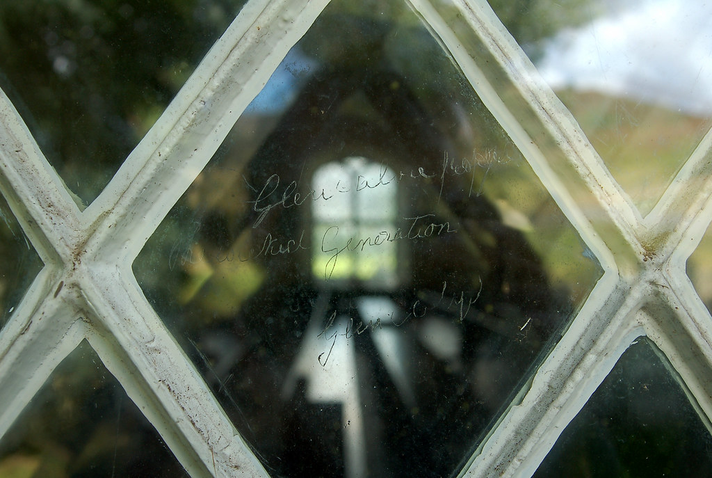
Time to shake off the winter torpor and stretch the legs on a long, pleasant meander from one coast to the other and back to the first coast again. Ullapool to Bonar Bridge and back to Ullapool via the haunting glass etchings at Croick church.
Weekend of 10/11 April.
Initial plan:
[*]Meet in Ullapool on Friday evening 9/4/10
Set off early Saturday morning 10/4/10 bound for Bonar Bridge.
Ritualistic behaviour upon reaching Bonar Bridge.
Turn round and ride back into the setting sun* like the fabled heroes of the Old West.
Ritualistic behaviour upon reaching the sea at Ullapool (probably involving nakedness).
Carousing.[/*]The route is a fairly non-technical ride of around 120km with about 1600m of climbing overall. Generally on fire road/estate tracks and tarmac with a couple of options for the outward and return legs. I'll post maps here in the next day or two. I'll also investigate accommodation options though each rider is responsible for organising their own.
There is also the option of starting in Bonar Bridge on Saturday and doing the route over two days with an overnight in Ullapool.
Post here if you are on for this early season opener – more to follow later in the year!
*Expect heavy rain throughout
mcmoonterFree MemberPosted 14 years agoSign me and Italspark up for this. I could do a car share from Fife up too.
sangobeggerFree MemberPosted 14 years agoNaked in Ullapool – bloody hell,you ARE keen.Pink rinse wifies will have a fit.
TandemJeremyFree MemberPosted 14 years agoStuartie – I memory mapped it and to me it seems a lot less – under 25 miles each way road to road, under 30 miles each way tidal to tidal. ( 80 – 100 k return)
I think for the old and slow amongst us it could work if we send the young and fit ones to do the unneeded 10 miles of road while we have a picnic and set off into the sunset in a leisurely fashion and allow you to catch us up.
I would like to do this but not if it involves spending all day struggling to keep up
radoggairFree MemberPosted 14 years agoerm , i may potentially make this, i think i'm on hol that weekend.
Slow pace, sounds good 🙂
doug_basqueMTB.comFull MemberPosted 14 years agoI've been planning something similar for ages but haven't got the chance. Best of luck to you all and I'll look forward to hearing how you get on.
stuartie_cFree MemberPosted 14 years agoTJ – your plan makes perfect sense, provided you dip your toe into salt water!
McM tells me the image link above isn't working, so try this one instead:
 fizzerFree MemberPosted 14 years ago
those window etchings are so sad – almost reduced me to tears when I went there. One of the most atmospheric places I've ever seen.
stuartie_cFree MemberPosted 14 years agoMap number 1:

(clicky)
I'll try something clever with Google maps, but don't hold your breath since I'm a bit thick.
NainosliwFree MemberPosted 14 years agoLet me see – I need to figure logistics but might be up for it, particularly the two-day version. Anyone else interested in that?
banginonFull MemberPosted 14 years agoSquare Wheels Steve and I did much the same route but starting at Bonar a few years ago, while I was up doing the trails at Bonar. Top[ big day out. Stop in at the Bistro at Bonar for some good midway scran.
italsparkFree MemberPosted 14 years agostuartie, ill be your gimp !
if i remember correctly there is a bunkhouse near/connected to the ceilidh place and there is a camp/caravan site on the peninsula both in ullapool( maybe worth checking if they open in april)
looking forward to itSwayndoFree MemberPosted 14 years agoAye, Ceilidh Place bunkhouse and the (decent) campsite should both be open.
stuartie_cFree MemberPosted 14 years agoItalspark – I've got the mask looked out and it's all cleaned up from last time.
Swayndo – cheers. I've emailed the Ceilidh Place to ask about how many places are available and I'll post here when they get back to me. If it's not a goer, the campsite is pretty good.
13thFM – shame you can't make that weekend – hope you enjoy your 4-dayer!
(My clever-thing-with-Google-maps experiment has failed so far…)
Fat-boy-fatFull MemberPosted 14 years agoDo you have a GPX for your route? I fancy doing just one way but I don't want to miss out any good bits. From looking at an OS map, it all looks pretty straight forward but if there are any small detours that are worth taking, I'd be interested in finding out about them.
TandemJeremyFree MemberPosted 14 years agoFat boy fat – doing it one way makes the logistics difficult – I have a old fat and slow shortened option which I will probably be taking – to inveroykel where the tidal limit is on the estuary. Let the fast boys zoom off while we have picnics and lie about in the sun.
stuartie_cFree MemberPosted 14 years agoGratuitous bump as it turns out as I've just checked my email to find this reply from the Ceilidh Place:
Thank you for your email. We are fully booked on 9th and there are 7 rooms with total of 15 beds available on 10th and more rooms available on 11th. The room only rate is £15 per person. I hope this make sense to you.If you need more information, please do not hesitate to get back to us.
I've booked myself in for Saturday night and I'll either camp on the Friday or stay in Inverness area and make an early start. If you're coming along, you'll need to make your own arrangements but don't leave it too late as I imagine these beds will go quickly.
The email address is stay@theceilidhplace.com
Cheers,
SCmcmoonterFree MemberPosted 14 years agoI've emailed the Ceilidh Place for a spot in the bunkhouse on Saturday night. I'll camp on the Friday, do they run the campsite too?
I went out on my touring bike to do a weather check on my endurance/sense of humour threshold. I rode most of the Etape route. There was a howling headwind most of the way with driving rain for good measure. I'll try and get a couple of long back to back rides in next weekend too.
druidhFree MemberPosted 14 years agomcmoonter – Member
I went out on my touring bike to do a weather check on my endurance/sense of humour threshold. I rode most of the Etape route. There was a howling headwind most of the way with driving rain for good measure. I'll try and get a couple of long back to back rides in next weekend too.
Aye – pleasant riding today weren't it?
We'll be up doing the Etape route on 25th April if you're interested.
italsparkFree MemberPosted 14 years agom.c. this is what you need http://www.broomfieldhp.com/index.htm ive just enquired about getting the campervan in for the friday and sat. night
druidhFree MemberPosted 14 years agomcmoonter – Member
Druidh, I might be up for that, mail me nearer the time.wilco – I'll likely post something up here too – and on the tbc website/facebook page.
stuartie_cFree MemberPosted 14 years agoRight – I have to admit defeat…
I've been trying to upload a .gpx file to the web so that it can be viewed by others.
The websites I've used before (bikehike and motionbased) seem to be defunct.
Any suggestions? This shouldn't be difficult for someone with a degree in Computing Science, surely…
druidhFree MemberPosted 14 years agobikeroutetoaster
email it to me if you're having "technical" problems.
stuartie_cFree MemberPosted 14 years agoThanks Druidh.
OK, if I've managed to do this, you'll find a route map at:
http://bikeroutetoaster.com/Course.aspx?course=113680
I was hoping that I could see it against an OS map background on the website, but this should let you download it as a .gpx and view it on any mapping software.
jimmyFull MemberPosted 14 years agoIs it there and back in one day? Or overnight in between? Sorry if I'm being the thick one…
TandemJeremyFree MemberPosted 14 years agoWith an optional shorter there and back route possible for those of us who find 80 miles scary 🙂
This would give time for my schedule of picnics. Ride the first half of the outward route together, send the fast boys off to do the longer second half, old and slow go to the limit of the tidal reach not to bonar bridge itself, fast boys pick us up on the return after we have had a suitable picnic and siesta. Return all together. Go to pub and swap tall tales
druidhFree MemberPosted 14 years agostuartie_c – Member
Thanks Druidh.OK, if I've managed to do this, you'll find a route map at:
http://bikeroutetoaster.com/Course.aspx?course=113680
I was hoping that I could see it against an OS map background on the website, but this should let you download it as a .gpx and view it on any mapping software.
Try wheresthepath
mcmoonterFree MemberPosted 14 years agoI think it always good policy for someone in the group to know 'wheresthepath'.
italsparkFree MemberPosted 14 years agoi emailed the campsite folks and they say just to turn up and pitch as they are never busy at this time of year
stuartie, what tyres do you recommend for c2c2c ?stuartie_cFree MemberPosted 14 years agowhat tyres do you recommend for c2c2c?
Round ones tend to work best. Possibly with snow studs…
AlonelypufferFree MemberPosted 14 years agoLots of other options for places to stay…
The Arch Inn (next to campsite, behind the CP) http://www.thearchinn.co.uk/
West House B&B (next to the CP, behind The Arch)http://www.westhousebandb.co.uk/ + Richard used to run the hostel and is well into his bikesDunno how to use this mapping route stuff to download routes for you but…
If you want a shorter loop route using Ullapool as your base then go out along Rhidorrich, Take the hill path to your right and follow it SE over the hill towards the masts. Go to mid braes and follow the old road along to Leckmelm (runs above and parallel to A835), then go NNE over Campbeltown and down to the East Lodge about 8 miles futher along the estate road you intially left from. Hope that makes sense! Great ride, places will be muddy at the moment.
Fancy a wee ride but with some steep climbs (!) and descents?
Drive round to Corrie Hallie and do a loop to Shenavall Bothy http://www.walkhighlands.co.uk/ullapool/shenavall.shtmlany snow that fell is rapidly dissappearing on all but high ground, burns are high though
devsFree MemberPosted 14 years agoStill don't know if I'm available for this. Hopefully I am. Will confirm next week.

The topic ‘STW Scotland – Ullapool to Bonar Bridge C2C2C’ is closed to new replies.