Viewing 22 posts - 1 through 22 (of 22 total)
  • mapping site – comparing current and historical maps
  • maccruiskeen
    Full Member

    Now…. I’m not sure if I dreamed this. Is there a site that gives two map views – one a current map (can’t remember if its google maps or OS) and the other an older OS map so that you can see where features have changed, disappeared or fallen off the map.

    Sure someone linked to it from here once but a provisional google hasn’t turned it up

    druidh
    Free Member

    For Scotland?

    http://geo.nls.uk/maps/

    cbike
    Free Member

    National library of scotland has one. There used to be a really good one that used OS data but I suspect OS got it pulled and replaced with their own shoddy one?? It was linked from single tarck about 4 years ago??

    http://geo.nls.uk/search/mosaic/#zoom=16&lat=55.86703&lon=-4.12031&layers=B000000000FFFFTFFFFFFFFFFFFFFFFFFFFFFFFFFFFFFFFFFFFFFFFFFFFFFFFFFFFFFFFFFFFFFFFFFFFFFFFFFFFFFFFFFFFFFFFFFFFFFFFFFFFFFFFFFFFFFFFFFFFFFFFFFFFFFFFFFFFFFFFFFFFFFFFFFFFFFFFFFFFFFFFFFFFFFFFFFFFFFFFFFFFFFFFFFFFFF

    maccruiskeen
    Full Member

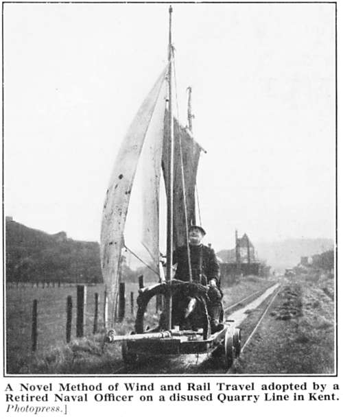
    nice! but not Scotland on this occasion – I’m looking at a particular area of Kent – plotting a commute to work an ancestor of mine used to do along a railway line using a bogie and a sail. I can locate the ruin of his house but not the railway yet…. or the destination. He was a coastguard but his coast guard’s cottage wasn’t by the sea – so he’d sail to work

    maccruiskeen
    Full Member

    There used to be a really good one that used OS data but I suspect OS got it pulled and replaced with their own shoddy one??

    so it wasn’t a dream

    boxelder
    Full Member

    wheresthepath

    ?

    pdw
    Free Member

    Maybe not quite what you’re looking for, but this site has scans of out-of-copyright OS maps: http://www.npemap.org.uk

    yossarian
    Free Member

    Which area of Kent? I’ve got a box full of old Kentish maps around somewhere.

    maccruiskeen
    Full Member

    that npemap link is pretty useful – shows and names the cottage and can extrapolate the likely route of his rail/sail ride from that on something that is marked as as tramway. Good stuff!

    Can work back from that to geograph / google earth the sites as they are today

    maccruiskeen
    Full Member

    Which area of Kent?

    The Cliffe Marshes. The dickensian soup my ancestors emerged from 🙂

    I’m a bit vague as to the actual dates we’re looking at – can’t lay my hands on the family tree stuff to date the story

    yossarian
    Free Member

    Ah, Cliffe. My wife works for the Brett group who own a large part of that area. Drop me a pm if you like and I’ll ask her to see what she can find out.

    Most of the maps I’ve got are of Thanet and the Canterbury district

    maccruiskeen
    Full Member

    Cheers Yoss – I’ll bookmark this thread and maybe drop you a line when I manage to dig out the relevant dates. Plan is for me and my brother to turn the bit of family oral history into story book for my nephew and niece. . . . . before the whole place disappears under an airport ❗

    andytherocketeer
    Full Member

    erk small world (ex-cliffewoods here – ‘rents still live there)

    definitely remember seeing old vs new maps online for there. Wheresthepath sounds familiar too.

    yossarian
    Free Member

    Cool, no problem. Nice idea btw

    maccruiskeen
    Full Member

    erk small world (ex-cliffewoods here – ‘rents still live there)

    See the Golden House chinese take away on Church St- how its a newer building than the ones around it? My grandad used to have a job cleaning out the range in the chipshop that was there before it when he was a kid (he lived next door)

    Anyway, one day he was fooling around and…….. burned the whole place down.

    andytherocketeer
    Full Member

    Girl in my class in primary school used to live there. I remember a portion of chips costing 10p or something. Can’t believe it’s a chinese now (actually I can) – it’s just wrong.
    Lived in Chalk (not far away, and also of Dickens fame), then CliffeWoods, but went to school in Cliffe. Left when I was 18 to go to uni, but still go back once per year. Used to play out on the marshes as a kid (and on the Hoo railway line too, but I don’t recommend that!)

    maccruiskeen
    Full Member

    When my grandad burnt the old one down the guy wasn’t insured, nor was my grandads mum. The local court sentanced my great grandmother to cook the chipshop owner his supper, every night, forever.

    phiiiiil
    Full Member

    wheresthepath

    This! Dead useful.

    Where’s the path?

    Drac
    Full Member

    Oldmaps.co.uk I think that’s the URL use to be very good and sure OS site offered a comparison too.

    andytherocketeer
    Full Member

    Haha – like the sentence. They should do that sort of thing more often.

    Had a bit of a nose about on wheresthepath. Think it was the one I saw ages ago. Be handy to know the date for the OS Historic maps.

    clubber
    Free Member

    As above, where’s the path is the site you want.

    http://wtp2.appspot.com/wheresthepath.htm

    maccruiskeen
    Full Member

    Apologies the for the thread revive…… but found something better than a map – the man himself and his sail bogie – not a blood relation as first thought but at the time so many families were bring up other peoples kids (my grandad had his own brothers and 8 other ‘taken in’ kids in his house) family history can get a bit baffling

    But check this dude out!

Viewing 22 posts - 1 through 22 (of 22 total)

The topic ‘mapping site – comparing current and historical maps’ is closed to new replies.