- This topic has 16 replies, 4 voices, and was last updated 15 years ago by slowmedown.
-
Long Shot: VTT routes in the Cevennes/Lozere?
-
StonerFree MemberPosted 15 years ago
Want to explore this region and I see a lot of 7 day randonnee holidays in google telling tale of many miles of VTT routes but I cant find any route guides, waymarked trails, or marked maps. Anyone got any or some pointers on where to find?
There’s nothing useful on the FFC VTT site, I have found a few ideas on Utagawa but most are end-to-end randonees.
cheers
owenfackrellFree MemberPosted 15 years agoI went to the east of the cavennes a few years back and found some vvt routes.
If you go here and then pick the one nearest to where you want to go it will tell you what routes they have near by and where you can get the map showing the starts.StonerFree MemberPosted 15 years agocheers owen but Ive tried the FFC site and there are no regional centres that cover the cevennes/area around florac. there’s a big hole in the coverage.
slowmedownFree MemberPosted 15 years agoStoner, its endless, I love to ride in the Cevennes, IMO one of the best places anywhere to ride. Mt Lozere is an excellent day. I find the way marked routes are nothing like the best there is to do.
Geoportail is your friend. Stick to the paths that are shown as being waymarked, because they will be there. I have ridden there many times by just making my own routes up and never had less than an awesome day.
If you want to ride in the western side of the Cevennes, mail me at jusandrhi at yahoo, and if it works out maybe we could meet up.trailmonkeyFull MemberPosted 15 years agoAll you have to do is click on the part of the map of france that you’re going to and the map for that area will come up. It will givew you a basic idea of what’s there.
When you arrive over there, pop into the LBS or tourist office and pick up the route cards. The trails will be waymarked on the ground with a little triangle and two circles, a bit like this 8>. I’ve ridden in the Dordogne, Charente, Suisse Normande vand the southern end of the Cevennes using these trails.
Just to whet your appetite, here’s a couple of shots of the lower Cevennes. Yes, it was as hot as it looks.
StonerFree MemberPosted 15 years agoslowmedown – top stuff, cheers, will check out geoportail. Problem with Utagawa is the routes all seem to be put up by psycho frenchmen who like to spend all day climbing not railing trails! 🙂
I love florac and all the way up to nasbinals.
a couple of years ago mrs S and I rode across Spain and France and went up the gorge du jonte/gorge du Tarn, florac, marjevols, nasbinals way and loved the area.
blog
http://pompinos.blogspot.com/route log
http://www.gmap-pedometer.com/?r=251238We’re back in Spain and France for May, this time with camper van and will probably stay at Florac camp site for a week towards the end of the month (early part of the month going to be in pyrenees).
Will take your details with me!
slowmedownFree MemberPosted 15 years agoFrom Florac, climb up to the causse to the west, pick any path down into the Tarn gorge cross the river, climb to Mas Andre, down to Ispagnac, cross the river again, climb to Le Tomple, back to Florac, fall asleep!
StonerFree MemberPosted 15 years agoTrailmonkey – as I said to Owne, Ive used the FFC site before and its been OK, but it has a big hole in its coverage of lozere.
slowmedownFree MemberPosted 15 years agoI live a couple of hours west of the Tarn gorge, and often make the trip, put Valleraugue on your list as well, riding on the ridge to the East is amazing, fabulous descents both sides of the ridge
StonerFree MemberPosted 15 years agoslowmedown, when you say ” Stick to the paths that are shown as being waymarked,” do you mean the GR paths marked on the IGN?
trailmonkeyFull MemberPosted 15 years agoStoner, you may just have to jump in the car and find some elsewhere. It won’t be too far away I’m sure.
StonerFree MemberPosted 15 years agoyep – will explore, but as SMD says there’s plenty there, its just how best to make the most of it in a week without a guide. Usually VTT waymarks are the quickest way of getting in some good trails (if not the best) but the info on the net can be inconsistent.
slowmedownFree MemberPosted 15 years agoHope you enjoyed your night ride. By waymarked I mean GR’s but also PR,s mostly normally marked as a pink dashed line on the IGN maps.
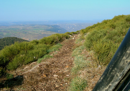
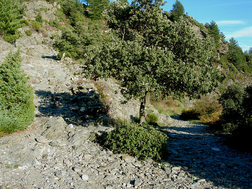
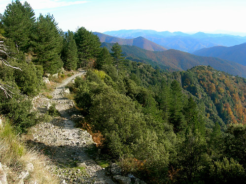
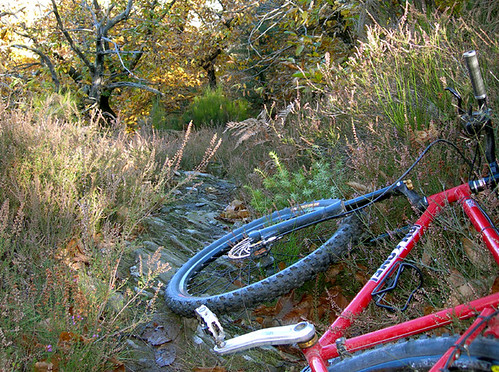
Here be some pics to inspire, none taken on ‘MTB’ routes, all easy to find…
In that last pic the trail went on like that for soooo long!slowmedownFree MemberPosted 15 years ago1st pic, park at Treves, long, dull soul destroying tarmac climb to Col de la Pierre Plantee, Col des Rhodes and on to the col east of Serre de Combescure, descend to Dourbies, excellent, then up the road then grassy track to Col des Ubertes, back to Col at top of Dourbies descent, then go via Serre de Combescure and Mont Mal path a bit vague but findable, photo just after Mont Mal, follow endless series of paths (past the anc. mine) back to Treves…Treves is in the bottom of the 300m deep valley that cuts the flatland that is the background to the pic!
rest of pics… Start Valleraugue go down the main road for 3k turn left climb the road then track to Bonperrier, follow ridge east to Col de l’Homme Mort, down to Souhes and Les Plantiers (last pic…) Then up to Col de Tinquos and on to Col de l’Espinas then up towards the Aire de Cote at the col where the GR6/GR67 joins the road go down them back to Vallerauge via 2nd and 3rd pics.
Sorry for long and dull route descriptions but should let you find them…


The topic ‘Long Shot: VTT routes in the Cevennes/Lozere?’ is closed to new replies.