- This topic has 344 replies, 126 voices, and was last updated 8 years ago by boxelder.
-
Flooding
-
binnersFull MemberPosted 8 years ago
Every road in and out of Rammy is now closed. The main bridge in is now closed too, even to pedestrians. The height of the Irwell is bonkers. This is the water running down our road..
[video]http://youtu.be/4Ke7EYPs6GY[/video]
This is where it’s ending up, in the Irwell…,
[video]http://youtu.be/nfnKnY1GwsE[/video]
The rain briefly stopped while we were out. It’s now bucketing down again! 🙁
bikebouyFree MemberPosted 8 years agoWent out this morning in biblical rain storms up on the moors north of Harroagte. Torrential rain and broken rivers and the reservoirs are busting. Turned back on a couple of the lanes up near Pateley Bridge/Wath so headed up over the moors to Kirkby Malz, still pissing down but now I’m back at the farm the clouds breaking… A bit..
1-shedFree MemberPosted 8 years agoJust watched the video of Hebden Bridge and has brought a tear to my eye. As a family we visit quite often and love the town. We will be back and support the local businesses. Hope it stops soon.
slowoldmanFull MemberPosted 8 years agoHave a look at GaugeMap online to see how crazy the levels have been.
That’s an eye-opener.
piemonsterFull MemberPosted 8 years agoOnce it’s gone, come back and spend all your money, the communities are going to need it.
Planning on it already!
Stay safe folks.
TurnerGuyFree MemberPosted 8 years agoThey are saying that every river in Lancashire has broken previous height levels…
monkeysfeetFree MemberPosted 8 years agoI should be on nights tonight, however I can’t get onto Anglesey. A55 is submerged after J15 -11. Bonkers weather. 😯
langyladFree MemberPosted 8 years agoThey are saying that every river in Lancashire has broken previous height level
That is quite something considering the levels they have already been at this year. Was just about to take the hounds for their daily stroll down to the Ribble, don’t think i will bother.
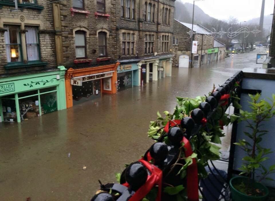
binnersFull MemberPosted 8 years agoThat’s heartbreaking seeing Hebden like that.
Just hope lives haven’t been lost. When you see the raging torrents the rivers have become
JeromeFree MemberPosted 8 years agoStill raining hard in whalley.
Imaging it may be coming over the bridge on the Calder now.
Will pop down later as not much else to do…mattyfezFull MemberPosted 8 years agoCalder has burst the banks at brighouse, not as bad as Hebden but a fair few cars /homes business flooded.
horaFree MemberPosted 8 years agoI was in Hebden Xmas eve. Bought pork belly and venison sausages from the butchers.
As soon as its up and running again I will be there.
If only the Tories cared.
Larry_LambFree MemberPosted 8 years agoBloody nora, that’s sad to see Hebden like that.
It looks bloody deep against the shops down the main street like that. As others have said I’ll be making some trips to spend some dosh that way.
somafunkFull MemberPosted 8 years agoMuch as i love to bash the Tories at every valid opportunity i fail to see how you lay the blame on them for this trifecta of misery.
As i see it (i may be totally wrong)
We are entering an El-Nino weather cycle that historically has played silly buggers with the jet stream in the southern hemisphere – this moves warm weather patterns northwards into Europe which leads to increased rainfall and strong winds.
We have had pretty much constant rain for the previous 6 weeks
Saturated ground can only accomodate so much water before it creates the perfect environment for flooding, even minimal rainfall that in previous years has not posed a problem becomes exacerbated when it falls on a rising water table.
Nothing short of designating vast swathes of the countryside to be set aside as flood plains with heavily engineered run off channels to deal with this problem could make a difference, if the government and thus farmers (they’d need massive compensation) who are willing to allow their land to become incorporated into such areas allow this then the problems may be localised into certain areas, until such a plan is built this will happen again…and again.
djgloverFree MemberPosted 8 years agoWe cannot get out of Ilkley at the moment, even the high level routes have flooded with water in dips
thepodgeFree MemberPosted 8 years agoAny pointers getting into Tod from the burnley side that I’d need to know about?
Planning to visit my dad, he says it’s fine but he sounded hammered and we have different levels as to what’s fine as I’ll be driving the family in and it’s a 2 hours drive from where we are now
GregMayFree MemberPosted 8 years agoWater has stopped in Hebden, starting to drop a bit. But more rain due.
Suggested headline: F**ked
 bigjimFull MemberPosted 8 years ago
I don’t think this is really the tories fault, though when it stops they or more likely the snp will claim they stopped the floods
Here’s an interesting pic of the atmospheric river that is bringing all the rain and storms
https://m.facebook.com/story.php?story_fbid=954633534617629&substory_index=0&id=208916149189375
binnersFull MemberPosted 8 years agoPodge – I wouldn’t even attempt that journey at the moment! Your odds of making it all the way through are slim to non-exist any. There are roads closed left, right and centre, and no reliable information as to which.
There’s a lot more rain forecast
The fire brigade are appealing for people not to travel unless absolutely essential, as pulling peoples stranded cars out of flooded roads is diverting resources away from genuinely essential emergencies.
Please stay at home!
troutFree MemberPosted 8 years agoour carpet warehouse is under 2 feet of water in Crosshills along with a few other businesses and a mates house has been flooded also .
The canal was overflowing in lots of places but quite impressive between Kildwick and Silsdenwetist ride I have done for ages strangly the flood water felt warm when the bastid coming the other way just kept his speed up as I was axle deep in a flood between gargrave and skipton was a bit amusing as I could not get any wetter before
SaccadesFree MemberPosted 8 years agoJeez – was supposed to be coming over from Ireland tomorrow…
Not too sure if I’ll bother – A5/A55 flooded, can I even get off anglesey? (fast ferry is not running either).
Then more trouble on the m60/m62.
GregMayFree MemberPosted 8 years agoJeez – was supposed to be coming over from Ireland tomorrow…
Not too sure if I’ll bother – A5/A55 flooded, can I even get off anglesey? (fast ferry is not running either).
Then more trouble on the m60/m62.
We’re supposed to be going to Ireland on the 28th. I’m not holding my breath that it’ll happen.
SaccadesFree MemberPosted 8 years agoGregmay ex-worc?
We’re wet but not too bad over here tbf, rivers high but not near flooding.
curses.
binnersFull MemberPosted 8 years agoThe bridge on the main road into Rammy is still completely closed. They’re worried it might be about to collapse. There’s footage online of shipping containers being carried down the Irwell, hitting the bridges. Ones been taken out in Radcliffe, and a gas main with it. Looks quite dramatic, to say the least! 😯
I wonder which wellies Dave will wear when he comes to see us all? 2 trips North in a year Eh? 😀
projectFree MemberPosted 8 years agoSaccades – Member
Jeez – was supposed to be coming over from Ireland tomorrow…Not too sure if I’ll bother – A5/A55 flooded, can I even get off anglesey? (fast ferry is not running either).
Then more trouble on the m60/m62.
big hole apeared in M62 as well road closed
http://www.dailypost.co.uk/news/local-news/live-heavy-rain-brings-flooding-10652352
GregMayFree MemberPosted 8 years agoGregmay ex-worc?
We’re wet but not too bad over here tbf, rivers high but not near flooding.
curses.
There can be only one 😉
So yeah. That’s me.
SaccadesFree MemberPosted 8 years agobugger.
Appears there are diversions… What do we reckon, an extra 3 hours?
Mate has a 4×4 with a snorkle, I’m tempted to give him a ring.
thepodgeFree MemberPosted 8 years agoThanks for the info binners, I’m going to reassess in the morning, being a local I know routes over the top to avoid the valley bottom but as you say, no point in causing people more issues when they are already busy so we might postpone.
grumFree MemberPosted 8 years agoBig landslide on the top road between Burnley and Blackshaw Head. Wouldn’t be surprised if some of the other top roads are dodgy too.
thepodgeFree MemberPosted 8 years agoNobs to that then, I’m not avoiding floods just to tangle with landslides.
RustySpannerFull MemberPosted 8 years agoRawtenstall very bad this afternoon, brother in law filling sandbags as we speak, culvert coming off the moors has burst at the top of his garden.
Walk Mill and Cliviger dodgy too, Red Lees Roaad closed.
I’m 46, not seen it this bad before.
How many times for Tod and Hebden now?
It’s heartbreaking.
Stay safe everyone.ircFull MemberPosted 8 years agoOne view back in 2008 was that we were entering a period of higher flood risks as part of a long term natural cycle, not global warming.
He looked at seasonal rainfall and river flow patterns dating back to 1853 which suggest fluctuations between very wet and very dry periods, each lasting for a few years at a time, but also very long periods of a few decades that can be particularly wet or particularly dry.
In terms of river flooding, the period since the early 1960s and until the late 1990s appears to be relatively flood free, especially when compared with some periods in the late 19th century and early 20th Century. As a result of analysing rainfall and river flow patterns, Prof. Lane believes that the UK is entering a flood rich period that we haven’t seen for a number of decades.
More than three-quarters of our flood records start in the flood-poor period that begins in the 1960s. This matters because we set our flood protection in terms of return periods – the average number of years between floods of a given size. We have probably under-estimated the frequency of flooding
https://www.dur.ac.uk/geography/news/allgeognews/?itemno=6479
nick1962Free MemberPosted 8 years agoAny pointers getting into Tod from the burnley side that I’d need to know about?
I agree with binners(for once!),don’t attempt it.The main Burnley Rd is closed, flooded and impassable in at least 3 places in Tod and Halifax Rd and Rochdale Rd likewise. There are some ways to avoid parts of these roads but you inevitably will get stuck at some point.Tod was cut off from all directions a couple of hours ago.
thepodgeFree MemberPosted 8 years agoThanks nick, all the info is about roads, any idea if trains are making it through? Thinking we could meet in Manchester or something as he’s desperate to see his grandson.
GregMayFree MemberPosted 8 years agoTrains are off in the Valley at the moment. Line is a canal between Walsden and Littleborough.
They were off today anyway, but I wouldn’t expect them to be on tomrrow either.
nick1962Free MemberPosted 8 years agoTrains have been off before with far,far less rain.Not seen or heard any trains today but that maybe because it’s Boxing Day.Check the train websites for tomorrow.
thepodgeFree MemberPosted 8 years agoCheers guys, still going to reassess tomorrow morning but thinking we’ll stay up here a while longer. Just sucks that grandad and great grandad won’t get to see the little lad
johnx2Free MemberPosted 8 years agoYorkshire’s no longer cut off from ilkley, fwiw. Queues getting round abandoned cars on the moor road mind you.
Went for a bit of a biblical xbike ride earlier. Thigh deep crossing the main bridge. Had to concentrate when I hit the current.


The topic ‘Flooding’ is closed to new replies.