If anyone is interested?
[img] 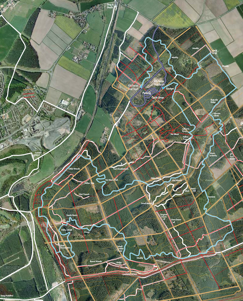 [/img]
Seen this before but not as useful as it may seem as you need local knowledge to follow it on the ground. Sherwood could do with a few key sign posts at fire road junctions much like Swinley has, at least that way you have an idea of where the car park is. Mind you I never mind getting lost as I constantly find new trails, can't find them again though! 😆
The trail isn't complete yet, once it is there will be a whole host of sign posts.
Yep, thats cleared that right up!! Makes about as much sense as it does on the ground!! Went the other week and have to say that it could do with alot more signs, bits just seam to go round and round.
When we got going tho, we did have a good time so will be back.
skiprat, if you're interested in a local tour round, give me a shout when you're next over this way & I'll see if I'm about or some of the other locals. We've been riding there since '94 so know it pretty well
Thanks Goldenwonder, i'll let you know when we're there next. Like i said, we enjoyed it when we got into it, theres some nice flowing paths there, be great when its a bit dryer too!!
It's pretty good at the moment now it's drained off loads, much more predictable without the 3" of sludge on the top!
There's loads to go at now, miles of which will never get signed
Thats a nice map. There was one similar on here a while ago from someone called pinenut (before singletrack forum was reborn).
I have just set up a website about Sherwood Pines. Would It be OK to link to your map?
There are sign posts all the way around the light blue (Kitchener trail) route but they don't have arrows on them pointing in the right direction.
[url= http://sherwoodpines.synthasite.com ]www.sherwoodpines.synthasite.com[/url]
Cheers abductee, I'm happy for you to link to the map, I can email a high quality pdf if you wish. it was born out of me wanting to string together routes for our regular wednesday night rides, and I know it may be hard to follow but I posted it as it seems better than the one Paul at the shop can offer riders.
Pinenut was my previous incarnation, but as I tend to fall off a lot... new name
I would welcome a high qualioty version too please - justin at louthnet dot com
thanks
how about a little stw gathering sometime over the next few weeks ?
I'm well up for that! STW gathering - excellent!!
STW gathering at Shady Pines? Eeeee! I remember when...[url] http://www.mountainbikerides.co.uk/photos_section/stwride.htm [/url]
are the new trails done yet ?
are the new trails done yet ?
not finished yet
TFG,
Could I also get the PDF version please. E-mail in my profile.
Cheers!
14th March anyone?
pdf here please...tlyons10@aol.com
ooh, pdf me too please
chris at soundhouse-media.co.uk
If you send the pdf to me I can stick it on a web server and put a download link here. Save you a load of emails....
pdf's sent to all that have asked, cheers for the offer of the link Pad Pierre, hope you have received the pdf.
STW gathering sounds like a good idea, anyone care to mention a day?
It's now available to download here: [url] http://www.mountainbikerides.co.uk/routes/other/PinesTrails.pdf [/url]
When I get a mo I'll stick an option to download on my site (if that's ok?). I'm happy to credit you when I do....
14th March? i've made it a new thread up top, but me and a mate we're on about doing it then anyway - it'd be good to meet you all
Could well be interested in this. As i'm home that weekend.
Thanks fallguy. I am abductee3 at g00g1em4i1 dot com.
I've been for another ride round today and its really muddy.
Low point - MUD
High point - the new section that has recently been built marked on your map filthy black and old woods.
I am uploading some more video to my website but it's all at a walking pace because of the MUD
[url= http://synthasite.sherwoodpines.com ]www.synthasite.sherwoodpines.com[/url]
@abductee - your site seems to be down.
i've been lurking on STW for the past couple of weeks, but joined today due to the interest in Sherwood Pines! (i only live in Worksop so its quite close for me)
EDIT - @abductee - ignore me - i have just re-read this thread and spotted your 'deliberate mistake' - (you'd think people would know their own domain name... 😉
"High point - the new section that has recently been built marked on your map filthy black and old woods"
They were there in december, Has nothing more been built since then?
On the original map, do you have a key for it?
Obviously blue is the Kitchener trail
What are fat white lines? All the kitchener is on fat white lines, but it can't be singletrack as theres singletrack bits I know signified only as red dashed lines?
So are red dashed lines? Non kitchener singletrack?
Presumably fat brown lines are the big wide fireroads?
Are narrow red solid lines the 1-2m tracks? In which case, what are red lines overlaid onto fat white lines?
Please help
abductee: do you want one mailed to your new address?
James, there is some crossover as the new trails utilise some of what was already there before.
Key to Trails as follows....
solid white line with blue centre = Kitchener trail
solid white lines = Most popular singletrack or routes I use most
Solid Red lines = original (pre Kitchener) doubletrack
Dashed red lines = original singletrack
smaller dash red lines = original singletrack + more technical /overgrown/ muddy etc
brown lines = fireroads and doubletrack
hope this helps
Thefallguy - Either address will do. Thanks very much.
Dawson - Sorry I was being a muppet. here it is again
[url= http://sherwoodpines.synthasite.com ]www.sherwoodpines.synthasite.com[/url]
/p>
James - I have been missing out the filthy black part of the route because it was filthy and black. I was surprised to find they had done it.
The video I took was all choppy when I uploaded it so I will have to convert it again.