yes, very sad, been riding there 20-odd years.
I assume that once the barracks closes and the area opens up there will be an off road route up the west side of the fenced off area. Whether it'll be as good as the fenceline though......
To be clear, the talk of resurrecting trails is not on Barossa Common but between A30 and M3.
i was talking of the ones on Frimley Fuel allotments / Frith Hill
alextemper - MemberTo be clear, the talk of resurrecting trails is not on Barossa Common but between A30 and M3.
The land accessed via Ligh****er Country Park?
I seem to recall there was stuff about the fuel allotments and restrictions or out of bounds to bikes, even if it's frequently ridden.
Out of interest (just been Googling), it was up for converting to a SANG (the more I hear this term the more I'm annoyed as it's just a backdoor to housing development that would otherwise be rejected).
Not sure this happened, or is it now the barracks are the SANG?
Is there any old trails in the vehicle testing area off the back of High Curley? Had a look once and I think I remember seeing a few bits. Also the run down parallel Red Road there were a few animal runs and natural drainage channels.
alextemper - Member
To be clear, the talk of resurrecting trails is not on Barossa Common but between A30 and M3.The land accessed via Ligh****er Country Park?
Yup, bottom of the vehicle testing area and access under the M3
Scamper - Member
Is there any old trails in the vehicle testing area off the back of High Curley? Had a look once and I think I remember seeing a few bits. Also the run down parallel Red Road there were a few animal runs and natural drainage channels.
Not much but lots of potential that I keep considering given I pretty much back onto the Country Park. There's a great sweeping run down from the viewing point but given as that area is widely used by the public for walking it's not one I would advise unless you pick a quiet time or are in a very small group.
There are bits that cross between the loops of the test track and sections near Red Road and the M3 cut in by MX events but nothing I would class as a fun trail to ride for an MTB having explored a bit. Main problem is that you will will be running off either side of a ridge so and trail will be a run to nothing. A bit like Pitch Hill at Peaslake. Traversing would require a lot of work and hours to cut in and clear although it would result in some fun trails with the gradient on offer.
This.... there are some trails but what there is are mainly deep rutted motorbike ones and also they can climb directly up the face of the slopes which is beyond (most of) the mtbers that ride this area. There used to be some in the area bounded by ligh****er / red road / maultway but I haven't ridden them for years, mainly because PP & TH are / were so much better (sobs)
Just come back from TH & the loggers are really making their mark - it's a big area they are working in......probably most of the SW corner. Hardly any trails there left at all..
The rest of the area seems ok for now..
TH or Porridge Pots ?
TH.
Area W of the Old Guildford Rd running alongside the main road.
[url= http://www.streetmap.co.uk/map.srf?x=490090&y=154865&z=120&sv=490090,154865&st=4&ar=y&mapp=map.srf&searchp=ids.srf&dn=539&ax=490090&ay=154865&lm=0 ]Map - hopefully..[/url]
Yeah, they've totalled a large part of TH, but I suspect once the cut wood is removed most of the trails will recover quickly.
Logging across a lot of MoD so it's not exclusive to those area with trails running through them. The bottom of Ash Ranges on the Pirbright side has had extensive clearing for months now.
Enjoy the trails while we can and start giving some serious thought about other developing alternative areas. There's a lot of talking about trying to save what we have but not much talk about considering alternative options when the inevitable happens.
Apparantly 'access control measures' (whatever they are) are being put in place for additional barriers on some access points to Minley to prevent 'illegal' parking..................
A thread I started that hasn’t ended in a day...
I started this because I wanted to get over to these areas that I’ve never been to but Ironically started a major contract so just can’t get time to go over there.
can anyone tell me if its still possible to get from the canal crossing (tunnel hill/porridgepot) up to Ligh****er through Deepcut and along the Maultway, staying off road?
Also can i get from Lakeside Park at Ash up to said canal crossing via tunnel hill?
ta
[quote=mahalo said]can anyone tell me if its still possible to get from the canal crossing (tunnel hill/porridgepot) up to Ligh****er through Deepcut and along the Maultway, staying off road?
Also can i get from Lakeside Park at Ash up to said canal crossing via tunnel hill?
ta
Don't know about Pt1 with the new fence (I suspect there is a route).
For Pt2, Ash to the canal crossing, yes that's doable via various routes. If Ash Ranges are open then you can zip across the top of the ranges to Tunnel Hill, if ranges are shut then you can go round the perimeter (or along the canal towpath) to Ash Vale station and then follow the track running parallel to the railway line to get to TH.
“can anyone tell me if its still possible to get from the canal crossing (tunnel hill/porridgepot) up to Ligh****er through Deepcut and along the Maultway, staying off road?”
In the short term, this will depend on whether the gates are open
In the medium term, there’s cycle infra planned through the PRB housing development and SANGS that will link colony/mainstone gate area with the canal when the gates are shut. That’s a planning condition staged so that it has to be in place before X number of the new houses can be occupied.
County councillor (Mike Goodman) held a meeting with local cyclists last week regards Surrey Heath cycling plan, and PROW and recreational links will be considered in that too, including DIO/MOD liaison
so where are the gates? what is the alternative if they are closed?
Ladders
Maybe Pots will be open at times after all, if you believe Michael Gove.
From TAG:
An update:MP Michael Gove has replied saying Deepcut gates will remain open when the land is not in use. This is contrary to the FOI request, so we are seeking clarification. If correct, then a great piece of news as public access when not in use is maintained and well done to everyone for contacting the local MPs and raising their concerns.
The construction of the Long Valley fence has started, with assurances the gates will be left unlocked when the land is not in use. As an aside, the work clearing the scrub for the fence may have opened up a few more kms of trails...we will keep pressing for advance publication of closure dates and times so everyone can plan accordingly.
Current TAG Chair Simon Brown was interviewed again by local broadcaster Thats Surrey TV:
Just been out for a spin at the local lunchtime jump spot as i liked to call it... (the small area south of Mytchett Pl Rd, Tunnel Hill Table Topm / Grinder / Psycho Spiral as theyre known on strava..)
its gone. they've flattened the lot.
the big step up, the fallen tree drop, the table top, all the other little kickers and drops dotted around the place. its total devastation.
the absolute F"£$%^&*&^%$£"£$%^&^%$£"$%^&*'s
gutted 🙁
Having seen the way they've cleared the ground for the fence around Long Valley, any expectations that it'll be 'rideable' may be open to interpretation. I'm somewhat cynical of 'leaving gates open' from the DIO - the Bourley Lane car park was temporarily closed for forestry work 2 years ago and has remained firmly locked since. When I moved to Fleet 29 years ago there were about 6 parking areas around the Long Valley area within the fenced area accessible to the public - there is only 1 now on Bourley Lane, doing a good impression of the Somme with bomb craters.
@mahola takes the piss but I'm not surprised. They had been clearing up the top and it was starting to get over developed with more jump lines appearing and its traffic was well on the increase. A year ago you could ride through and not see anyone else while more recently you would come across groups sessioning the lines. Not saying is right or making excuses for that area being trashed but it follows the same trend as Peaslake with unofficial trails becoming more developed and busy until it's not tolerated anymore.
Can any of the locals confirm what the state of riding is to the North East and South West of the Old Guildford road ?
I was planning on riding there Saturday, but upon reading this thread (which is a few days old) I wondered if its now logged / flattened or now out of bounds.
Cheers.
@Trimix - Absolutely gutted to inform you (you may already have found out) that P45 and Tight Like a Tiger are currently destroyed by logging operations. P44 still OK, but not worth the trip over there. Once the wood has been taken away, no doubth the TH trails will come back to life, but for a few weeks/months now, it's a no-go area. At least the fenced-in area North of the canal is still open (for now)
Rode over there for the first time in ages, and yes - huge areas of TH are trashed. Hopefully it can be recovered in time, but it'll take time.
Looks like there may finally be some good news regarding trail access and cooperation with MOD/DIO....
https://trailactiongroup.co.uk/2018/03/16/tag-and-mod-tentative-progress/
...though from reading the statement it still seems there is the possibility of the whole deal being derailed by the belligerent/selfish minority.
Fingers crossed for better times ahead!
What's the latest on the porridgepot fence? Now that the clocks have changed Mrs P is thinking about commuting again and her old route went from the Curzon bridge to the maultway/red road roundabout. Does she now have to stick on the towpath all the way to Deepcut?
'nother bump about this - anyone been that way lately?
The gates are still open on Porridge Pot, I am not sure when/if they will be shut. Maybe when the houses start getting sold.
Thanks - expect the day they shut them will coincide with her first attempt at a commute home 🙂
More MOD gates!!!!
The MOD have been getting fed up with people parking in passing places, blocking access gates etc and have now installed gates across the roads to Minley Manor and Hawley Woods. You can still squeeze past on a bike, but vehicle access for local parking is now restricted. Probably will affect dog walkers more than cyclists but it appears to be yet another erosion of public access to the military training land..................
Do you mean the gate to get to the sailing club or a different one?
There are now gates across the road that leads to the parking area outside the sailing club .
What’s the score with the trails & logging round TH? Have they recovered or is it still a mess?
Bit of a mess, a lot of it's still blocked.
Rode a trail on Tuesday that I helped clear on Thursday (blocked with one tree) and it had 5-10 trees on it, so either the army are blocking them or we've got a new stickman to contend with as well as the logging detritus.
The first zig zag up the hill is open, the bomb holes are open, p45 is open but a lot around it isn't, there's a new triail from the top called "ladies first" on strava, the loop round the top of the hill on the other side of the railway is fine, trenches are fine, area51 is fenced off. Porridge Pot is fenced off, but the no-entry signs have disappeared.
And there seems to be dog shit f******* everywhere,
All the gates around Long Valley have been locked since the Farnborough Airshow and I expect little chance of seeing them open again. When trying to raise the issue on local FB groups, get accused of 'being the problem' or 'making it worse' by simply accessing the areas when not in use, in accordance with the bylaws.
Have noticed TH cleared trails seem to keep gaining more debris and the odd big ones across the trail. I'm not convinced it's just weather. Also they go through randomly with the mulching machine with no real logic to it other than straight across an existing trail.
But we do have newly gravelled fireroads.
And yeah, Pots and LV are permanently closed. The former yeah there may be a way in but it was signposted out of bounds now the SANGS is open. This is not what the byelaw specifies. It's supposed to be open when not in use, not closed because there's a sanitised gravel path next door for the housing estate. These are public open spaces that were acquired by MOD for use on the understanding the public would still have access when not in use.
Pots is clearly intended to be permanently shut (they've said only open at xmas/new year, but I doubt even that). LV is promised to be open when not in use, and it's definitely not in use 100% of the time, but it has been closed 100% of the time since the air show.
Write off Pots and LV basically, but don't expect that's it. They just need the money for more fences and the forthcoming review of the byelaws to remove public access from the majority of public access MOD lands. We have no real say in it, even if they let us say things, they just do what they want regardless, even against promises to our MPs.
p.s. there's been issue already with Pots where they claim people have been cutting the fence, so they're putting CCTV in to catch people. This is clearly not on and I hope MTBers aren't involved.
A51 fenced off??
Yes, A51 fenced off. As I understand it, MOD weren't happy with the enduro trails creeping onto MOD land, so they (MOD) put up a fence to mark the boundary.
I think in the long run we can basically say goodbye to any riding on MOD land locally - what will happen nationally I daren't speculate..
But it seems clear the MOD want to kick the public off the training areas & then sell it on to developers. The strategy they are currently employing certainly seems to suggest this.
The MOD is broke & has land, there's pressure to build more housing QED the MOD are going to sell off TA's to developers, pocket the £ & there'll be F all we can do about it!
It's a really sad state of affairs.
Unfortunately someone at MOD has clocked that in order to stop public use of the land, all they need to do is put a fence round it and the existing byelaws already give them the authority to prevent use.
Subject to the provisions of these byelaws the public are permitted to use all parts of the military land not specially enclosed or the entry to which is not shown by notice as being prohibited or restricted...
TAG is fighting it and there were assurances provided by MPs and DIO (via responses to FOIA) that it wouldn't be a 24/7 closure of the areas, but somewhat predicatably this doesn't seem to be being kept to. TAG is monitoring the LV areas as often as we can to see if they actually ever open it.
The end game here is the byelaw review which DIO have confirmed is underway now. Broad timeline is that internal draft is due to be completed by April 2019 with the public consultation starting in June 2019. The byelaws will then come into effect in May 2020. The MTB community will obviously need to be organised in order to submit as many consultation responses as possible during the consultation period (a somewhat short 35 days).
So rather than A51 being fenced off, access to TH from A51 has a fence against it. But A51 is easily accessed from the road, isn't it, so can you just get on there..... or does the MOD own that bit of land?
sell it on to developers.
A fair bit of the MOD land is classified as SPA (Special Protected Area) so the developers wouldn't be interested (I hope!!)
A fair bit of the MOD land is classified as SPA (Special Protected Area) so the developers wouldn’t be interested (I hope!!)
In order to sell to developers they have to designate some of it as SANGS, which is a bit like accessible greenbelt and supposed to replace what's being lost (the supposed access to the training areas). SPA's and SSSI's just make it easy to decide which bits are houses and which bits are parks.
theotherjonv
So rather than A51 being fenced off, access to TH from A51 has a fence against it. But A51 is easily accessed from the road, isn’t it, so can you just get on there….. or does the MOD own that bit of land?
Private land and owner MTB friendly (hence the events allowed there), but it's still private and I believe only supposed to be used for race events.
Ewan
there were assurances provided by MPs and DIO (via responses to FOIA) that it wouldn’t be a 24/7 closure of the areas.
Out of interest, a comment was posted on a Deepcut FB group that they got this response from a FOI request in 2017, saying Deepcut was going to be fully closed all along. Was this not how they responded to you?...
Good Afternoon,
Thank you for your email.
Please find below the information you requested on the restrictions that will be in place;
Area Response
Deepcut (G2) No public access.
Eelmoor/Long Valley (B4) Public access permitted when training is not taking place. Access will be controlled by gates.Kind Regards
Defence Infrastructure Organisation
Well, the trails are all still there, and you can still get in, just saying.
Out of interest, a comment was posted on a Deepcut FB group that they got this response from a FOI request in 2017, saying Deepcut was going to be fully closed all along. Was this not how they responded to you?…
A TAG member received a letter from Gavin Williamson (the sec state) via Michael Gove (the deepcut MP) saying the gates for G2 (Deepcut) would only be locked when the area is in training use.
(edit: we're aware of the contradiction here - probably one of our FOI requests the person on the FB group is referencing)
Deepcut fence line was sometimes open but not now. I see this sign and always closed now 🙁
[url= https://preview.ibb.co/kVrjCz/20180815_232852.jp g" target="_blank">https://preview.ibb.co/kVrjCz/20180815_232852.jp g"/> [/img][/url]
Can anyone point me in the direction of a map with the fences on it?
I was riding this area today for the first times in ages and most of my regular routes to get down to the canal are now impossible due to the miles of new fences!
There's no access to the canal except via the road now, at least until the South SANGS is done where they're supposed to connect to the canal. Regardless, all the training area is closed off.
Map here. 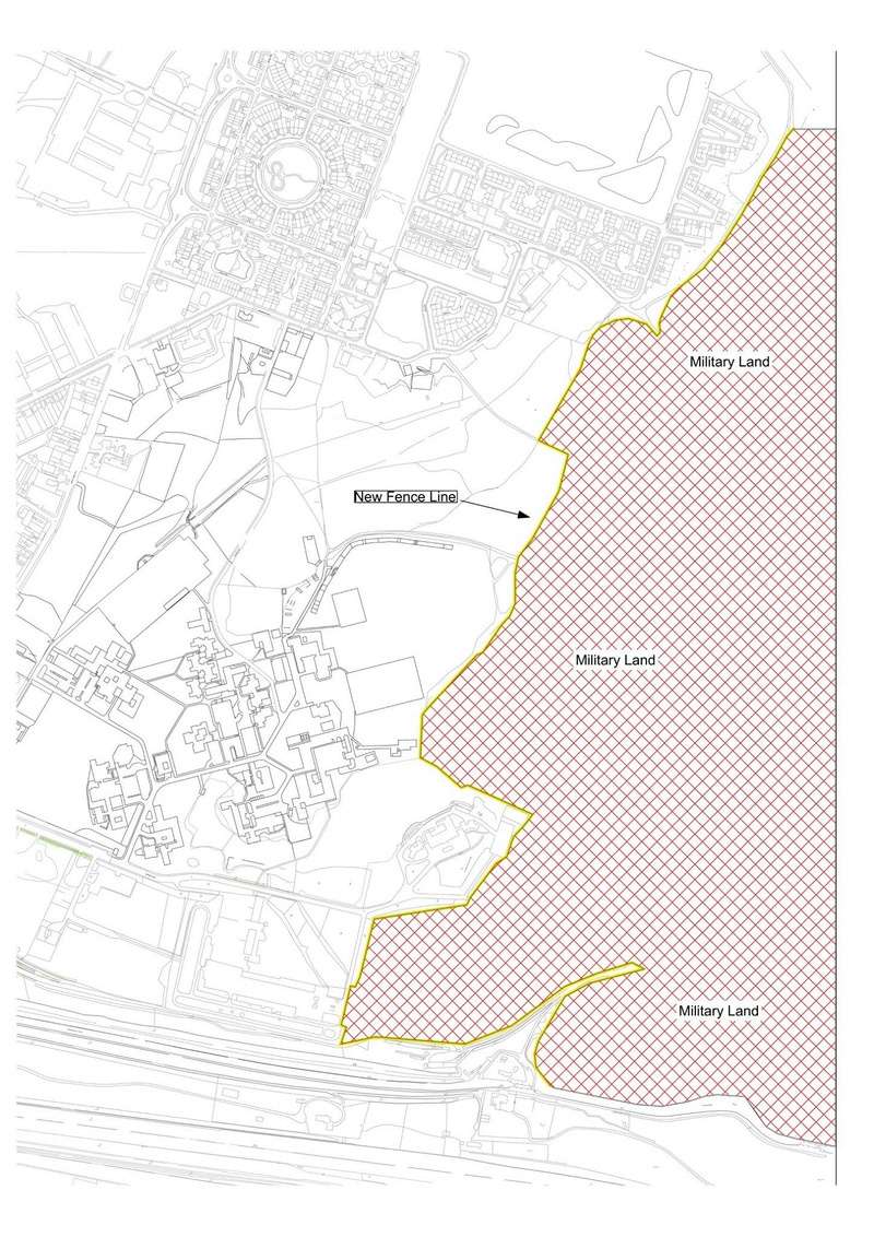
https://singletrackworld.com/forum/topic/tunnel-hill-porridge-mod/page/2/#post-9635157
Absolute mendacity from the MOD as to their long-term plans and ignoring the bylaws. Shamefully, local politicians aren't interested either as its not a vote-winner.
I was over LV this week - no one in green within the fenced area, but loads on the other side of the road which was a bit ridiculous. I suspect the over-riding criteria is environmental - the MOD simply don't have the will/inclination/money to put in sustainable environmental measures - so simply on the basis that they get to mess the place up from time to time, do nothing to let it 'recover' and exclude the public at all times.
It is noticeable that now having forced dog-walkers to be restricted to only a few areas, the dog-poo bins are beyond overflowing which is hardly an incentive for them to clean up.