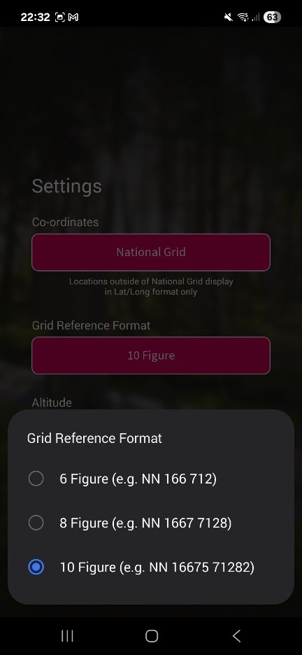
OSLocate can be set to show 10 figure grid refs, ie 1m accuracy. What its not very good at is giving me a decent elevation value, which is about 100m (vertical) adrift as I sit here. Granted I'm indoors right now, but it can be quite a way off outdoors too
I downloaded it this evening
Just tried to download on MrsEpic's samsung - playstore only shows OS maps, not os locate. Can only use OS Maps w a login. Seems a shame that such a useful app is not widely available
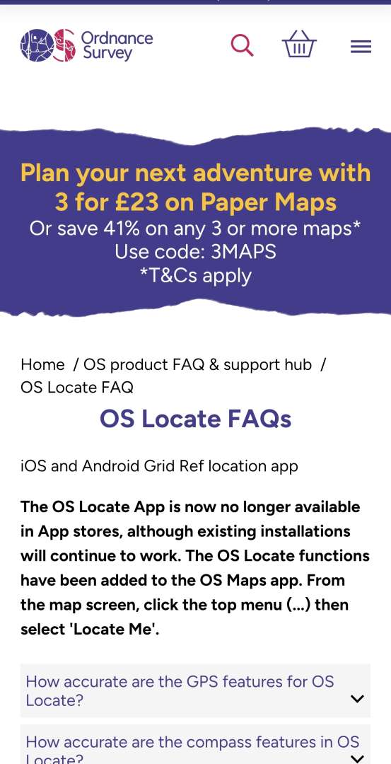
They stopped OS locate quite recently the app still works but they were supposed to not have in app stores any more.
I also have OS locate. Agree height not accurate around 50 or 60m out when I have checked against known height.
Great app for a one click to get grid ref for SOS or what I use it for checking my location on paper maps in mist etc
It was transferred over to my current phone from an old phone.
I managed to install OS Locate just before typing this. That was using my Pixel 8 and the standard Google Play Store. Perhaps it's because I'd installed it on another phone previously?
I've got UKGrid on mine which appears to do the same job, ie give grid ref and lat/long when you aren't sure. Doesn't do elevation though, but if you have a map you can see that easily e ought if you have your grid ref anyway
What advantage doesWTW have over OS grid refs?
More advertising budget?
What advantage does WTW have over OS grid refs?
Words are easier for a lot of people. They understand words cos they use them everyday whereas they don't understand grid refs or Morse code. I believe that was the thinking behind it.
I'm with the comments above though, I'm not a fan for the reasons given in the links.
More advertising budget?
Yep - those TV ads showing a helicopter appearing overhead a stranded surfer within a few seconds of him shouting 3 words into his phone seemed a touch optimistic!
doesn’t matter how good you are - it matters how good everyone else in the chain of typing your location in / copying it down is. I’ve no idea of W3W is actually better for error reduction than OSGB but OSGB is definitely not human error free.Personally I've never gotten a 6 figure grid ref wrong
have you ever searched for someone with just an OSGB ref? That’s a 10,000 m^2 area. About 1.5 full size football pitches. Easy enough if your casualty is highly visible on a flat bit of land. Not easy if the terrain is complex. In the urban environment even more difficult. Of course all gps based locations have a risk in complex terrain of being misplaced anyway but that problem applies equally to all grid ref systems.(easily big enough to get a search team to find you),
and it's fairly easy to give over a phone call in the wind, but of course it could be mistaken the same as anything
is fairly easy good enough for a distressed caller? We aren’t necessarily talking about “sensible” people who presents with NO012289 read it calmly and professionally as November-Oscar-One-Two-Two-Eight-Nine. Ask anyone who has worked in a call centre - the public are idiots.
I don’t know if it is or is not better - UK Coastguard use it with members of the public whilst using OSGB for land locations and Lat Lon for marine locations for their own assets. That suggests to me they find it useful when dealing with muppets., but maybe less so than a short combination of words that have many homonyms and are close by.
well that may be part of the issue - even the global one has three flavours of format, which can lead to errors for the inept. The “local” on has multiple levels of resolution but even a a six figure ref requires 8 words, and for similar precision to W3W you need 12 words. Is 12 opportunities for mishearing, mistyping, bad writing worse?And personally I just don't see the point, there's a perfectly usable system available. Two in fact, one local with massive historical use, and one worldwide with even more.
are we looking at that from a British perspective? Does every country have a great grid ref system? Lat Lon has a lot going for it but it’s verbose and typographical/transpositional errors MAY be less obvious.Why add to the mix (I know why, they wanted to make a system they could sell, simple).
if you ever need to print a very precise location (eg on an flyer) and have another user type it in to their device - it is without doubt better!I find that irritating, and the fact that it's not "better" in any way makes it even more irritating - we made a thing, it has more problems,
nobody forces ES to use it - if they have adopted it, it is probably because it actually offers them some advantages when dealing with the great unwashed.please all use it and now force the emergency services to use it also.
now if the OS Locate demise is true then it kind of blows out the water all the “there’s a great system readily available” arguments and the “a commercial company can stop anytime” worries - a state owned solution can just be wound down too!
I still don’t know why any ES is asking users on mobile phones for their location - it’s included automatically in the data sent to BT when you dial 999/112 from smartphones that are new enough to run W3W!
The whistle pattern is 6 blows with a minute between sets, and 3 blows for the response.
Thats off the printed panel of the emergency bag that Harrier do, who also do very good very and quality hiking/running poles.
I just bought a couple of their adjustable carbon poles that I carry in the rucksack for emergencies, carbon so they are light and adjustable as I might have to lend them to someone else so no point just getting my length.
What a useful thread
A few practical points
I usually ride alone. I always use strava beacon. This is included in the free version of Strava. My assumption is that if it all goes wrong i might well not have signal. But my wife will have my route upto the point where i lost signal. This should massively cut down the potential search area. “Find my phone” and other location sharing services do nothing if you have no signal
I don’t like what3words as a concept but i have the app on my phone. Because I’m not anti enough, to not have it, if I’m asked to use it in an emergency
My iPhone 14 should allow satellite text to the emergency services
I’m pretty strict about an extra layer
If it’s remote I’m take a battery pack. I’ll also make sure i have the OS map downloaded. FYI in pretty sure the OS map App is free and therefore the correct option for everyone’s who wants a grid reference. What you pay for is full topo mapping and the ability to export a gpx
i need to get a whistle
I agree that most of us are bullish about how fast things would go wrong if incapacitated and i include myself.
The hardest thing I’ve done on a bike was a 2 day gravel event in Wales. I ended up riding in a group of 4, 2 of the others were carrying a chunk more than me. I had a 3 litre frame bag and a 5 litre bar bag covering food, spares, tools and clothes. So i think just enough. Coming out is of a checkpoint some one said that i looked heavily laden. They were in shorts and a long sleeve top with a few bits in a jersey pocket. This was a route that went over to over 500m off road. The next day we were in cloud with horizontal rain in the middle of know where. I mean if you want to chance your arm in packable jacket that’s fine. But maybe don’t criticise those who have packed a few more layers. MR response time is in hours, that’s a lot if time cooling down
Talking of grid references. I have been using GridPoint GB for years (mainly for early accurate locations when letterboxing on Dartmoor). It’s a free app and gives you a 10 figure grid reference (1 m2) barely uses your battery. If doing anything that requires a map I usually carry an OS map for actual navigation, but for MTB I’m usually just following known trails or know where I am.
“Find my phone” and other location sharing services do nothing if you have no signal
I don’t like what3words as a concept but i have the app on my phone. Because I’m not anti enough, to not have it, if I’m asked to use it in an emergency
My phone says that Find My will still work even when switched off. Although HOW that works I've never looked into - not sure if it gives last known location of the device or actually has some sort of beacon that's permanently on...?
Same with W3W. I have it on my phone because it's a lot easier to have it if the shit hits the fan than to have to download it while standing on a hillside in the rain. I have the full subscription OS Maps app too, that's my default for actual nav and wayfinding when I'm out walking or riding.
Sorry to hear your original story jon, hope you recover quick. I am also a mainly solo mtb'er but usually just tell my other half where i'll be. She is linked into my garmin tracking, more so for when I do longer trips (multi day) etc than local loops. Carry a small whistle in a bag, I am intrested in these emergency shelters for the multi days, will have to invest in 1 of them. Good thread
have you ever searched for someone with just an OSGB ref? That’s a 10,000 m^2 area.
The OS Maps app and OS Locate both provide a 10 digit grid ref. That's a 1 metre square.
OS Locate is now bundled into OS Maps as a feature called "Locate Me". Including the free version of OS Maps I have.
Interestingly while they agree on location they are around 50m different on height. I am hoping Locate Me is height accurate. Anybody checked?
I am hoping Locate Me is height accurate. Anybody checked?
It's giving me a much more realistic altitude (292ft) than OS Locate is doing (455ft) right now. I suspect its taking that from the basemap raster, rather than trying to derive it from satellite data. Ive not compared the two whilst out and about in the open air yet, but my experience is that OS Locate is pretty poor at it generally. Its grid refs are bang on.
I thought of this thread when I came across an interview with Robin knox Johnston. Puts solitude in in perspective. Incidentally I don't know why I find long distance sailing so interesting when I have never done any sailing at all.
https://m.youtube.com/watch?v=7-sT17xm6XU
