Here is the link for your file, which will be available for 7 Days or 100 downloads.
https://www.yousendit.com/download/Y1RwUXVqRnd3NUtGa1E9PQ
Cheers Oggles.
Ive just watched the you tube footage linked, one by one, and really impressed. cant wait to heal quick and get riding, only 50 miles from me, defo one of the first places im going. I haven't been up that way since the NEMBA's.............
Also thanks Oggles, I'm away from home this weekend (currently sat in a tapas bar in Cardiff) so I don't have access to the file.
Agree with Lowey about the speed humps, couple of odd lumps in strange places on the last section of blue as well.
Off to Afan tomorrow, haven't decided which trail yet.
I agree with both too many berms and the speed bumps, I would like to see some more natural singletrack, but will need to describe that a bit better. Will ride it again next week. When is the next dig? 🙂
Next dig is a week on Sunday.
Not sure I agree with there being too many berms although I do agree some more flowing fast less technical singletrack would be nice. I've always enjoyed the old section of red into the valley and the little bit around Stephen Park.
Looks like a consensus is forming. We need to feedback to Martin, coming along to a dig day is a good way of doing it 😉 .
I can't open the .GPX file! Has anyone got the Garmin .tcx file or know how to convert the .GPX file so I can import it in to Garmin Connect?
Kind Regards
do a google search for GPS converter
Thanks,
I have a converter or 2 and I still cant import it in to Garmin connect or motionbased to download to my Garmin Edge 705.....
Anyone else having this problem?
Update.....
nbt I have sorted it, used tcx converter and downloaded directly to the GPS unit. I will post to Garmin Connect if we get there on Sunday, thanks Guys....
what time and where is the meet point next sunday please?
thanks 🙂
Does anyone have a postcode for the carpark?
Car park is here
http://www.streetmap.co.uk/map.srf?X=374680&Y=454920&A=Y&Z=120&ax=374680&ay=454920
Streetmap reckons BD23 4SY
Nice one everyone - gonna head up there later today with the gf
Is the black gully section the sort of wiggly looking bit near the north east corner of the trail? I can see a short section branching off there. Any other black bits? My gf will want to avoid them.
Cheers
you can skip any of the black bits. The berms come after the slab: they are marked as black due to the consequences of failure rather than technicality, so make sure you go down them!
grumm-if she doesn't fancy the really big berms, she can ride past to the right there is the old red route down, it meets the bottom of the berms at an old ruin. You'll know when you get to these, as there is a little rocky step down section at the top.
Whoops you've probably set off by now.
Still here - I'll be going soon though 🙂
Thanks for that. She's not normally too bad with big berms, it's steep rocky stuff she doesn't like (and boardwalk!). Watched a few vids and it seems like she should be ok with most of it.
Went for a couple of laps this morning (semi-bearded bloke with severely clashing dark clothing/sky-blue helmet on a Pitch Pro, if anyone noticed...), found it a very decent work-out with plenty challenge to keep things interesting. Accept that fire-roads are a necessary evil to get you to the good stuff, but still loved the climbs, though there seemed some odd choices here and there that broke the flow up a little, those curiously sized / spaced speed bumps as has already been said. Be interesting to see how it develops under the traffic it's going to get, slip-fest in the muddy section through the trees, hopefully riders will exercise the caution muscles when it's wet through the 'swoopy canyon'.
It's quite tight in places compared to, say, GlenT, but no less enjoyable. Also got on about the best I ever have in a 'black' section, up the top. That slab slope is THE quick-hit rush. It's kinda like Laggan up there, if rather less intense.
Well done to all involved, you can really see the work that's been put in. Hopefully will join one of the dig days in the next few months; stumpyjon - will you keep posting the dig dates?
Cheers.
Many thanks nbt i found it before you had posted but will be handy for next time. Great afternoons ride. Loved the northshore, the slab was a quick rush and the berms are stunning. Some excellent singletrack it'll be a shame to see it all full of brake bumps form idiots who can't ride (IOM).
Thanks to all those involved and i will try to get up for a dig day asap.
Will do Rob, next date is as I have said a week on Sunday, one after that will be a fortnight later.
Best way to keep up to date is to email this guy:
Martin.Charlesworth@lancashire.gov.uk
He maintains the email list and usually sends out reminders and more importantly lets everyone know if a dig day is cancelled or postponed.
Not quite sure what his role is but he seems to organise a lot of volunteer type activities for Lancs council.
Not to be confused with he other Martin, Martin Colledge who is the FC driving force behind the project.
grumm-how did your gf. get on with the boardwalk? I got off the bike when the board walk humped up. I also didn't ride that rocky ladder descent in the woods, which was in the first section of volunteer built st.
We both really enjoyed it. My gf didn't ride most of the boardwalk section with the humps in it (or that rocky steep bit in the volunteer built section). She did ride some of the black section with the giant berms though, which she was quite pleased by. Not sure about the black grading personally.
If I was being critical I would agree with the comments about the bumps - I like getting two wheels off the ground and there seemed to be a lot of things that looked like they could be jumps, but because of the way they were placed didn't seem very jumpable. I suppose when I get to know the trail a bit better I might find more opportunities for jumping.
Just driving back from gisburn now. We got there for 830 the rain was lashing down, but wow, much better than expected. Really grippy( even the slab ) in the wet.
Pleased there is a place to mess about/have a quick blast only 40 mins from home. Looking forward to when it gets waymarked (the yellow crayon arrows did help tho!)
Wow! We (4 girls on Thurs night) had tremendous fun and I can't believe its almost on my doorstep. Plenty of "just nipping out, dear" to be had. We laughed loads down swoopy canyon but wouldn't want to do it after rain. The 'blue' back to the carpark was fun and will be great for kids. Will be revisiting very soon and will do the hump on the boardwalk now my heads round it.
Many thanks to all involved and I look forward to watching incredibly brave types going down that new (as yet unopened)black section. 😀
Was up there today in the pouring rain. Had a great time, however, the surfacing in the rollercoaster really does need thinking about. It was like ICE all the way down. I think its only a matter of time before there is a nasty accident there.
When are the marker arrow's going to be in place?
diz
Not before 3rd August, is all I can say for def.
Martin Colledge (the main FC guy behind the whole project) is back from holiday on the 3rd August. At some point, soon thereafter, he will remove the old two-way route signage and estabilsh the new correct one-way route. How quickly this happens, I suppose, will all depend on whether all the new posts have been put in correctly (in his absence) and when/whether all the plastic signage inserts are printed, correct, and in his posession.
Maybe another week or two, at a guess. Before he went on hols, he certainly stated it's his top priority.
i went up on monday afternoon, having never been before found the signage quite confusing. But, i enjoyed what i found to ride just exploring, great especially within 30mins of home, will be up there again friday i think doing some more exploring. at the moment i only have my full race hardtail or my race 4x bike, nothing ideal for such a place!
there was a guy on the black runs last time i was up an a ridged jump bike guess a 4x bike isnt far off?
As stated by stumpyjon in the OP and throughout this thread, [b]it is not officially open yet[/b]. FC have given the 'thumbs up' to ride all the new bits if you can find them, [b]but[/b] it is [b]not[/b] officially open until the new signage has been put in place.
By all means, turn up and ride everything you can find, but there is no correct signage in place yet, as it is not officially open!!!
hmm might take the intense across tomorrow, but i'll be pushing up the fire roads.
i don't really know where anything is across there, is anyone going this week/weekend that could show me around?
i might be going this weekend? or week?
do you want to let me know when you're planning on going? just drop us an email pimpcheese69@hotmail.com i'm at a loose end pretty much everyday for the forseeable future (graduate student looking for an automotive industry job = fail)
im a student bum who's life evolves around my bikes 😉
great, give us a shout.
have done
Anyone done it on a Tandem yet ???
Cleared the Black run at Llandegla on it , but lost my bottle a lot since then...tight switchbacks are a problem..
Cheers
Im heading up from Bamber Bridge tonight if anyone fancies it. Will be there for 5-530. Ive done it a few times but looks like ive been doing it the wrong way round :oops:, also hadnt sussed out where the volunteer bit is until now. Im looking out for a link-in from it to Dunsop Bridge 'black' route aswell if anyone knows one. Going to try and get a club ride out of it and possibly include this, dunsop and chipping. Should be approx 60-70k by the end of it.
daveDOTadamsonATmeDOTcom
A brilliant first outing to Gisburn this afternoon. Rode over from Garstang on my own but I'll be back with more people soon!! I got lost a few times, but that was to be expected seeing as there are no signs up yet! Thanks to yellow crayon man though, that made things a bit easier 🙂 I didn't anticipate the wetness and was using dry lube. Which washed off my chain after the first puddle!!
The boardwalk is well done, I can see it being a confidence builder for people like my dad who don't like riding the sawn stuff. (like at Grizedale) And the blue sections will be perfect for my little sister. Fun for the whole family.
I calculated the slab angle as approximately steep to the power of max. It was seriously windy up on that outcrop too. That whole top section is very cool with the multiple lines.
The bermcoaster is AWESOME so I did it again. I nearly washed out my front wheel in one of the puddles though, take it easy if it's wet.
Deffo worth riding the 50 mile round trip, even if i was into the wind the whole way back. With a lubeless squeeky chain. I'd have loved to do the loop again but probably wouldn't have made it back home! Props to everyone who has helped make this happen.
Thanks to yellow crayon man though, that made things a bit easier
That was me 🙂 , I should point out that all my yellow crayon markings were done in such a way that they will either disappear or be covered up when the new proper markers go in, I had prior knowledge of the route and I knew how the post markers would work, please don't anybody else start marking the posts. I apologise that it all went a bit pearshaped in the middle, but the FC foresters had put one post in the wrong place and (at the time) two posts were missing. I didn't realise this until I got to them, then I had a bit of a dilema, but decided it would generally still help people if they knew in most places whether to turn left or right. I haven't been able to get back and see if these issues have been sorted out, but the foresters were def aware of the post in the wrong place and they had more posts to go in situ.
rode gisburn tonight, and have to say it was cracking once i got some knowledge off the team bad lads that had riden there before! only a short skip across the trough from lancaster too which is great!
Also just rode it tonight with a groups of people I met in car park who showed us the way ...must have seen you at some point surely.
I'm off up there again (from Lancaster too!) tomorrow morning for a quick blast.
Nice to meet you pinches, keep checkin our forum for when we are next there. (that's if you want to ride with us again though!?)
yep up for riding with you boys again!
Junkyard, i was riding a rather inappropriate on one scandal.
Red Intense spider long hair faffing with broken GPS ring any bells?
white genesis / white pisspot for me. Pinches i remember seeing you there i think!
white pisspot rings a bell, i don't recall an intense, which is rare i'm normally quite the spotter of intenses
junkyard were you at the top of them big berms?
HI. Looking to head up here tomorrow (Sunday 2nd) for the first time but have just noticed there is a dig day? Will this impact on the amount of trail that will be open or is this new trail you are working on? thanks in advance!
Did it again yesterday and really enjoyed it. Did the slab this time - it's not really too bad, just looks a bit steep from above. It's good fun doing that and the section after with some speed built up from it. Got a bit more air on some of the jumps and bumps this time. Really like the two black sections and the volunteer bit.
Can anyone tell me whereabouts the downhill stuff is? Haven't spotted it yet while riding around. Need to see if I am man enough to attempt any of it 🙂
Bregante
It's a new bit of trail, so there will be no restrictions.
Grumm
The DH stuff (what's left of it after the clear felling) is a bit further along the forest road from where you would otherwise turn right into the quarry on the new xc route. There is an obvious big double on the side of the forest road which is a good point of ref.
right across the road from my vid 😉
whats the crack withe the way marking? went round the other night but people showed us round, don't think i could find the way again 🙂
Read the thread!
give me a break there's 8 pages! 😉
Life's tough sometimes. 😛
aint it
Rode there solo yesterday afternoon. No idea of where the new routes were so just followed fire roads until spotting the entry points. Yellow crayon man did me a service otherwise I'd never have known whether to go left or right after exiting.
Congratulations on the work you guys have done. I haven't visited since 2000 so a big improvement. I gave the slab a miss but enjoyed the black run.
Managed to take a couple of wrong turnings whereby I lost my bearings for a moment or two. Should be excellent when the signage is up. A bit of luck I wandered into a quarry and found a new line to Whelp Stone Crag.
A few general photos [url= http://www.pennine.fotopic.net/c1734156.html ]here[/url]
If you read the thread, there is a GPS file of the route - if you don't have a GPS/mapping software you can upload it to a site like bikehike.co.uk and get a map of the route. I managed fine navigating round using a screengrab of this which I sent to my phone, along with the handy yellow crayon arrows.
neil853 - Memberwhats the crack withe the way marking? went round the other night but people showed us round, don't think i could find the way again
Post at the top of this page explains the crack with the way marking. there's a map on page 1 or 2...
Map (for the hard of scrolling):
[img] 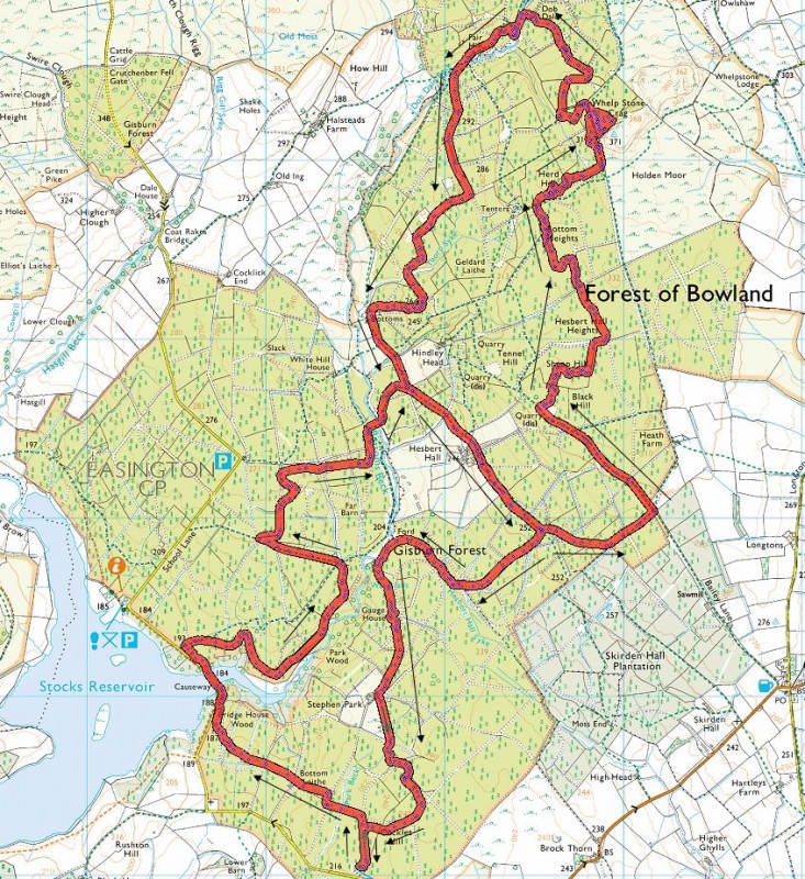 [/img]
link to loads of other photos [url= http://stumpyjon.pinkbike.com/album/Gisburn-Forest/ ]here[/url].
Anyone still want a .GPX file let me know or scroll back through the thread as some kind sole has hosted on the tinterweb somewhere.
Been digging again today, few new faces turned out which was good, more needed please. Forest was heaving today, big groups of 10 or so riders kept going past. The FC guy with us today kept shaking his head and sying he'd never seen it so busy.
To the guys I spoke to about helping out (with your own digger), email this guy:
Martin.Charlesworth@lancashire.gov.uk
he'll be able to give you contact details of the FC guys who you really need to speak to. Your help will be more than welcome I' sure.
Anyone know if there is somewhere close by to hire an MTB? I'm up in Preston at the weekend and hopefully taking the nephew out for a ride, but he needs to hire a bike first.
Cheers
Went up to Gisburn again on Saturday.It's highly entertaining and much faster on the cross bike! 8)I did get some funny looks though.
Only bits I didn't ride were the slab (Not because I wouldn't but I fear for the forks!) and the rock chute early on because there were folks walking up it.
I really do like the place, plus it's only 40 mins from home.
I was also wondering where the nearest decent hire place is?
I'm not sure but there is a local shop that will bring bikes out to the forest and meet you and pick them up afterwards. I think they have a board in Cocklett Hill carpark. If anyone's up there in the next few days could you have a look and make a note of the details.
Ta
Me and a few mates are off to Scotland on Wednesday for a few days and fancy doing Gisburn on the way back. It seems tough to navigate by the sounds of things unless you have a GPS? Is that right or is it easy to get round?
How's the signage coming along? Any idea when it'll all be in place?
It's pretty easy to navigate if you, say, printed out that map above as a backup, and then followed the yellow signs that B.A.Nana has crayoned on to the signposts. 🙂
I used an old Pendle Council map from years ago (less detailed than the one above). This enabled me to navigate the fire roads and find the trail signs. The 'yellow crayon man' did a good service by adding his markers. Without them you'd not know whether to go left or right on exiting onto a fire road.
I wandered into the quarry and found the red to the 'Slab' but may have missed a sign.
Anyway, it adds to the fun finding your way around.
awesome work stumpjon.
Went there yesterday - Sunday. I especially enjoyed the retro northshore and bridges - great touch - they tinkle like riding a xylophone.
My two boys (9 & 11) rode it and other than Sam having a paddy on the big berms on the black and leaving that big slab for me they did the lot & loved it.
I was there again last week and was suprised by the number of people who missed out the slab bit; they just had a look and couldn't be bothered.
I also met the most miserable man in the world, who couldn't even reply to a couple of simple "Morning"'s. His mate was a cheery soul, though, so I assume it wasn't me. Maybe he didn't like being caught?
It's not so much couldn't bothered with the slab, more scares the willies out of me, one fine day though it will be mine.
I had to think twice before shutting down brain & going for it
The slab is ace cos you get a great bit of speed up for the next section. Bit intimidating at first but it's dead easy really - just don't try and brake on it!
I found the slab fairly unimpressive; there is a section in a local ride that is steeper and rougher (quarry near Mitchell's House, Stumpy - do you know it?)
The rock steps in thre trees early I find more nerve-wracking; they are always look so slimey and wet. It's all in the head, though.
I built those steps so I had to ride them, bit of speed and don't panic and they are very doable, going to build some more on the next section. My mate pointed out that some of the drops on the coaster section are probably as steep as the slab, just a lot more friendly to look at.
Don't know the other drops, Mitchell's House rings bells though.