I've been given a bonus at work and have fancied a gps for quite sometime. the thing is there isn't alot of info any where. has any body used either the garmin oregons or the memory maps adveturer?
I have around £400 to play with. any help would be massively appreciated.
Another option...
Mapyx will launch a version of Lowrance Endura GPS in June:
http://www.mapyx.com/index.asp?tn=shop2&c=357
I've read a few bits about the Memory Map unit on Outdoorsmagic and I was a bit put off.
From my reading around, I got the feeling that the Garmin weakness is that whilst you buy the OS maps for the GPS unit, there's no way to use them on a PC for route plotting. Hence you'd either pay twice for the maps (eg Garmin + Memory Map / Tracklogs / Mapyx etc) or use one of the free online services.
I honestly wouldn't bother with the Memory Map unit. It just doesn't work particularly well. I reckon the best standalone GPS unit for navigating with OS mapping is the Satmap Active 10. Or, if you have a smartphone, ViewRanger software is very good. The Garmin units don't display OS maps very clearly, but otherwise are very efficient, particularly if you want something bike specific and aren't particularly bothered about the mapping side of things.
I'll be interested to see how the Lowrance unit works, the screen's quite small and they have an odd dual interface with both buttons and touch screen. I've used a pre-production version of the original Lowrance and it was okay, but let down by the very small screen I think.
There are loads of OS iPhone apps out as well, but battery life ain't great. The ViewRanger one seems to be the pick of the bunch if you can work round the short battery life and 'eek factor' of carrying a very expensive bit of hardware around with you on a mountain bike.
At the moment i am running an htc smart phone. I've tried a few different software packages but they either a)dont work, b) crash the phone or c) drain the battery in half an hour.
I can't have an iphone as t-mobile havent pulled their fingers out yet.
I'll have a look at the sat map. does the sat map have software to plan routes on the pc?
I was already tied into MM anyway and wanted a device to display my MM OS and other maps whilst out on the bike so I'm now using an Adventurer. I got it from MM with a UK National Parks set of maps. battery life is poor! but can be improved by setting the screen to close down after 10 secs and setting the brightness way down low. MM say you'll get 8 hrs from it then- I've not got that yet. However a quick trip to Maplins for a mini external USB power supply does the trick and I can get a couple of days riding from it. For more than that just get another PS. Once the warranty is up on mine I intend to beef up the internal battery anyway, there is loads of space inside the unit.
As for mapping- once you have a (recent) version of MM you can calibrate your own maps. Pedalhead form this parish put me onto a wicked app. (Mobac)that allows you to download maps from all over the globe to use on your PC/ Mac. Simple pimple. Also works on smartphones I believe!
Not heard good things about the memory map units performance. Active 10 has decent sized screen and mapping is cheaper than garmin.
I get by with a garmin geko and memory map - load route and make a paper map of it. Mostly it just gets used as a trip computer and nerd stats. Not sure if they do the geko now but foretrex offers simillar basic functions in a small unit.
The Satmap has an online route planner - initially it was free, then they introduced a one-off fee, I'm not sure what it is now, should say on the web site. You can actually plan routes on the unit itself. You can't run the mapping directly on a PC though.
Satmap charge you a yearly fee for using the online route planner, when you buy the unit you get a voucher for a years free use though.
The Garmin units don't display OS maps very clearly
Yeah they do
Have you seen GB Discoverer on the Dakota/Oregon range?
[img] 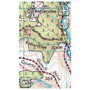 [/img]
Very happy with battery life running viewranger on my nokia 5800.
The Garmin units don't display OS maps very clearly
Yeah they do
Have you seen GB Discoverer on the Dakota/Oregon range?
Maybe they've improved then. The ones I've seen have been somewhat blurry compared to other units I've used. Do you find the Garmin screens large enough?
im using a satmap, very good, screen clear, gps aquisition is excellent
maps are a little expensive, bar mount is very sturdy
backup from sat map is great, i get about 12 hours frojm the li ion battery
the route planner supplied is basic, but a route can be planned and downloaded without too much grief
Maybe they've improved then. The ones I've seen have been somewhat blurry compared to other units I've used. Do you find the Garmin screens large enough?
Yeah - Large enough for my uses
Screen capture just taken off mine
[img]  [/img]
wish i could get my 705 to display os or memory map oh well cant have it all
I've got a Garmin 450t and am very pleased with it. Battery life, with a pair of Lithium AA's is about 10-12hrs? The screen is clear and easily read, even in bright sunlight. My unit came with the OS Discoverer National Parks microSd and the mapping is crystal clear. Thanks to Pedalhead (mentioned above), I've also been put onto the same piece of software that allows me to download custom maps into the unit, so I can have Explorer scale closeups of areas which blend in seamlessly with the lower scale, surrounding areas.
The unit itself is nice and sturdy, and the touchscreen is surviving muddy Scottish conditions well. The touchscreen controls are also fairly easy to use with gloves on.
B.
😀