https://m.facebook.com/groups/423493131097202?view=permalink&id=725260780920434
Sorry not selling - but hope someone on here can feedback
Does anyone know of a group of mountain biking lads out on Helvelyn today. Was atrocious conditions on the top with low cloud - visibility about 15 metres, snow on ground and freezing cold strong wind from the south. A group of about 12 lads on mountain bikes appeared at the top just as we were leaving (wife and I had walked up) was quite shocked by their attire, some in 3/4 normal mtb shorts. Did ask where there were heading - they were going to Dollywagon and then the route down from there back to Glenridding. They quickly went past as after we had set off. We were heading down the Thirlmere side - shortly after the fork in the path towards Dollywagon/Thrlimere we came across the group stopped part way down the Thirlmere path, one of them was doing a repair. Pointed out they had missed the fork and were going down the wrong side, in the visibility not too difficult. We continued on down and when nearly at the bottom came across 2 lads pushing bikes back up. Asked where they were heading and they said they had come the wrong way and needed to be towards Dollywagon. Turns out they were part of the same group, but had gone ahead whilst the repair was being made and only realised they were wrong when they got to the shore of Thirlmere. It was 14:10 by this time and they were proposing to climb most of the way back up Helvelyn to find the path they had missed - back into the low cloud - it had come lower by then and desperately freezing conditions. They didn't have any map, compass lights or any apparent additional thermal wear (one of them was in 3/4 shorts). Pointed out to go back up into those conditions was foolhardy and it was starting to get late and in danger of light running out. Suggested they head to Dunmail Raise and the path up to Grizedale Tarn and then down into Grizedale beck was a much safer and quicker route - this being below cloud level and no snow and wind much less at lower levels.Really quite concerned that they made it back OK so if anyone knows them would really appreciate feedback. Any suggestions of where else to post to get feedback appreciated. Have posted on Bogtrotters group - although they did say they weren't in Bogtrotters.
Crazyness. Can you imagine their panic 😕
Reports say their Saab has gone so the assumption is they made it back OK.
Is 'are you from the Bogtrotters?' the default question in this situation now?
Silly time of year to be riding high mountain peaks, so easy to ride or walk out onto a cornice.
hear hear dirty dog crazy actions
Silly time of year to be riding high mountain peaks, so easy to ride or walk out onto a cornice.
In the right conditions, "high mountain peaks" can make fantastic winter rides and be amazingly rideable. Winter descents of Helvellyn can be particularly brilliant.
Of course helps if you are experienced, know how to navigate, carry the right kit, food, drinks, set off early enough and carry lights!
Ha. Saw this too and thought about sticking it up here but apathy got the better of me. I think most walkers don't realise that their ascent / descent is three times less than what the average Jo on a bike can manage.
Reminds me of the time I was up on High Street in winter conditions a couple of years ago. I was taking a picture of my bike on the summit cairn and eating a flapjack, when a group of walkers all kitted out in crampons and axes appeared from behind some rocks. They looked quite shocked and proceeded to ask me all sorts of questions as to whether I had spiked tyres (I didn't which shocked them even more), knew where I was going etc.
Fantastic day out though:
[img] 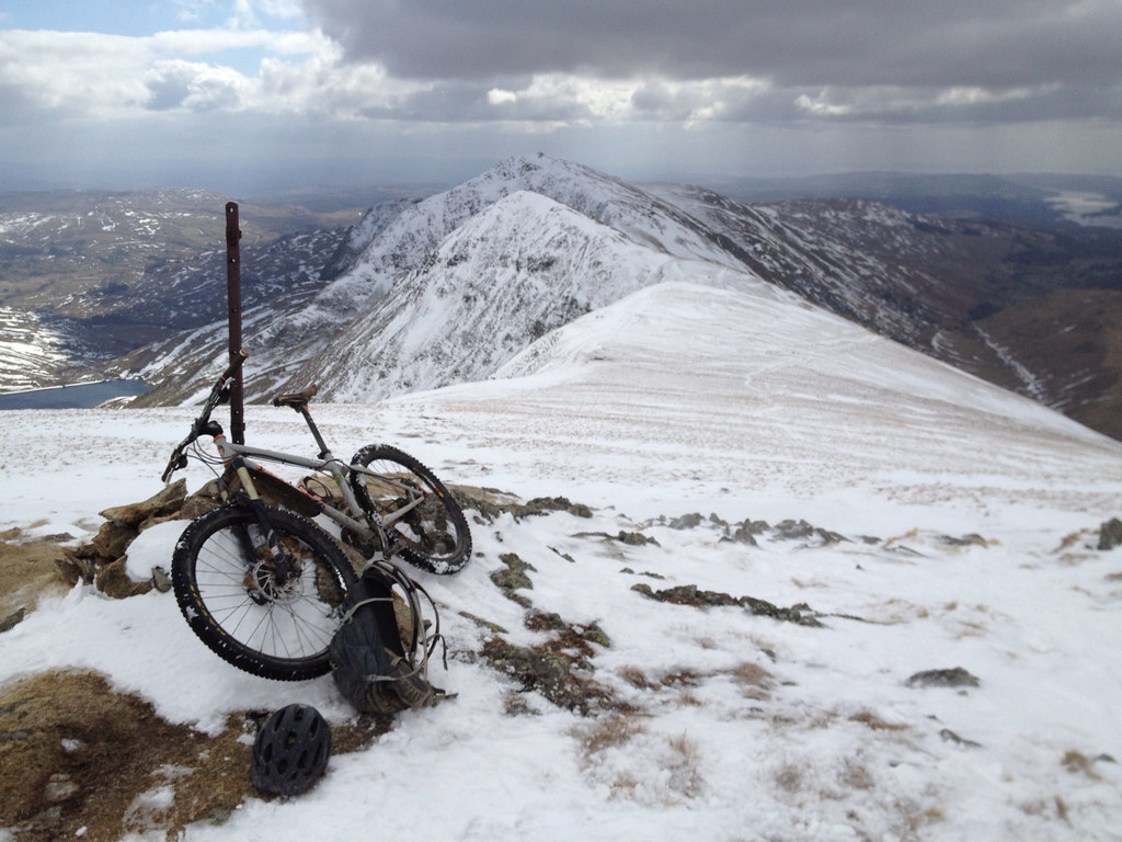 [/img]
I agree there is a bit of 'over protectiveness' in the post, and we all are guilty of over-kittedness and over-conservativeness at times, but equally the chap does make a good point or two:
They didn't have any map, compass lights or any apparent additional thermal wear
😕
Turns out they were part of the same group, but had gone ahead whilst the repair was being made and only realised they were wrong when they got to the shore of Thirlmere.
IIRC, the path fork is high up on the summit ridge, therefore two folk had ridden a 600m/2km+ of descent down pretty technical terrain, and not thought to wait for rest of group or check map?
I think most walkers don't realise that their ascent / descent is three times less than what the average Jo on a bike can manage.
On the flip side, as demonstrated here, i think on a bike it's much easier to make massive navigation errors that take three times as long to back track. I know so many mtbers who tend to just ride off blindly down a track and assume it's all good.
I don't think anyone's saying you shouldn't be prepared in the mountains and have the right navigation skills etc to safely play in them. However I've often come across a tendency among many walkers (usually whilst out walking, and not on the bike) who like to offer "advice" whether you want it or not, and who make lazy judgements about the ability of others.
It's not necessarily a daft thing to do, if you've got the right day for it and have enough kit. I don't ever really bother carrying a compass but usually use a GPS and a map and always have a spare layer. But I would usually do it in 3/4 shorts at most, and look fairly under dressed compared to a hiker as riding is much warmer work. A familiar, well known mountain like Helvellyn shouldn't pose an issue, though I'd not bother.
Sounds like some foolishness on the part of this particular group but it's not inherently a stupid thing to do.
We did Ben Lawers in November in the snow and that was staggeringly good!
[img]  [/img]
[img]  [/img]
[img]  [/img]
[img]  [/img]
[img]  [/img]
I would usually do it in 3/4 shorts at most
+1
Always pack a pair of thermals (top and bottom), but I've never been cold enough to use them. 3/4 and knee pads are fine for me, even in the ridiculously cold winter we had in 2012. What do other people wear, MTB trousers?!
3/4 and knee pads are fine for me, even in the ridiculously cold winter we had in 2012. What do other people wear, MTB trousers?!
i guess the point is less how cold you are when riding, but how quickly you get cold if it all goes wrong...
Those riders hadn't got much leeway for mistakes or breakdowns so they were well into the incident pit.
IIRC, the path fork is high up on the summit ridge
Yes, you are correct.
Have missed it myself once and had to contour around to the watershed above Grisedale Tarn.
, therefore two folk had ridden a 600m/2km+ of descent down pretty technical terrain, and not thought to wait for rest of group or check map?
STRAAAAAVVAAAAAA!!!!!
Those riders hadn't got much leeway for mistakes or breakdowns so they were well into the incident pit.
This. Obviously the vast majority of people who take a bit of a chance with clothing and equipment sail on through and just have a laugh about it over their evening pint.
We all call ourselves mountain bikers, but in truth, I don't think that many of us have more than a sprinkling of mountain know-how. I'd include myself in that, as my skills are more than a little rusty.
(Cue lots of indignant posts about carrying compasses and white-out navigation techniques...)
The bit about 3/4 shorts made me think they must know what they were doing TBH.
Cue lots of indignant posts about carrying compasses and white-out navigation techniques...
Smartphone with Google Maps turned to satellite photography mode 😉
Divers are familiar with the concept of the Incident Pit; I wrote an article for STW on this very subject a few years ago. You can "wing it" and everything will be fine but as soon as you use up your reserves you're on the slide. That can mean running out of daylight or energy, a breakdown, bad weather, minor accident, getting lost or having to retrace your route.
Smartphone with Google Maps turned to satellite photography mode
https://www.thebmc.co.uk/smartphone-apps-handle-with-care
The trouble with my bloody phone is I will probably die from hypothermia while waiting for it to get a GPS fix...
Does your Google Maps pre-download detailed satellite images, or do you rely on having a signal on top of the hill?
I had a bit of incident this weekend. Around half way round a route I had never ridden before in the Peaks my chain snapped. Unfortunately, my fingers were just too cold and I couldn't fix it on the spot. Even though it was only around midday, I was on my own, unsure what the rest of route had in store (other than from the map) and increasingly cold from the snow and the aborted attempt at fixing the chain.
In the end, I layered up, smashed down a tuna sarnie and decided the best and safest course was to retrace my route back to my start point.
Annoying more than anything and unlikely to cause me any real issues. But still, these things have a habit of escalating.
Does your Google Maps pre-download detailed satellite images, or do you rely on having a signal on top of the hill?
mine has viewranger with 1:25K OS maps of where ever I'm likely to be, preloaded. As long as there is a view of the sky and battery life it'll be fine.
I've often come across a tendency among many walkers (usually whilst out walking, and not on the bike) who like to offer "advice" whether you want it or not, and who make lazy judgements about the ability of others.
Oh yes, I've had many experiences of those, usually middle aged gents trying to impress their lady friends of their great mountain prowess. Best thing is to just take the pis,
As long as there is a view of the sky and battery life it'll be fine.
An increaseing number of MRT call outs are to people lost after batteries died on GPS's or they developed a fault.
I'm a bit of the old school and still rely on map and compass.
I was thinking initially how silly of them, until I remembered the day I was going with a mate to do some simple ice climbing on the E face. At the hole-in-the wall, we were in a whiteout but I said "no fear, I know Helvellyn like the back of my hand."
We spent the next 15 mins walking downhill towards the mines instead of uphill to Red Tarn! 😳
Cast not the first stone!!!!
I like the two gullies on the e face as they normally end in a cornice close to the summit shelter. Peoples' faces when you pop though is quite a picture!! Still scary thought if you cycled over the edge.
Does anyone know if they are def safe?
Garmin with freshly charged AA's (or new Duracells) will work for 3 days easily. that's why I take a Garmin that takes AA's. The phone each is merely an emergency backup, where GSM may work, but assume data won't (so have cached gmaps).
Map is in the backpack with the intention of never using it.
As I already said, I do not have a problem with anyone taking an adventure.
However, it does seem that this party (and increasingly more folk) are finding themselves in places with very narrow margins of error.
We also used to speak of incident pit/spiral/three lemons on the risk fruit machine gamble - and increasingly I see people who are happy to be on two lemons of three...
I think that modern kit (in all outdoor sports) narrows the gap between adventure and misadventure. The line between OK and accident is thinner, and more sudden.
I also think that there is a growth in sunny pics, massive adventures, shiny video's etc online, that flatten terrain/waves/distances/skills required/judgement being exercised. People head off into the hills, lacking the apprenticeship that they may have had in the past that would halt the incident pit spiral, or cause people to bail at two lemons....
Let's get out there folks, but please can we not rely on the big whirly bird and MRT as our fall back plan...when a headtorch, map & compass and an extra layer would avoid it.
I applaud sensible risk taking but feel that people are pushing the boundaries too far and becoming over reliant on technology (and rescue services 🙁 ). Off piste skiing is the worst offender IMO.
I have done a few 48 hr endurance events which have min kit lists. All fine and dandy when things are going well, but nowhere near sufficient if you have an accident and are sweaty, then cooling rapidly while seeking help. I was guilty there too because I ran (naturally) with the min kit required to pass the test but was very conscious that I would be in trouble if I had an accident in the middle of the night. Second lesson learned was that GPS can and do go wrong. I only had map and compass but was amazed at how those relying on GPS kept making navigational errors.
I will ride where I know well without a map. And if the conditions are bad, then a wrong turn can happen if I know it or not. And 30 seconds of wrong turn gets you a long way off course. I imagine someone in the group had a map and if not the map was in their head.
As had been said, you can get off a mountain pretty quickly on a bike so even if you are in the wrong place you get out of danger. From the wrong valley, you can usually get to the right valley on the roads. Unless you have had a nasty accident in which case you'd be struggling to get off the mountain even with a map and compass.
The guy was concerned though, so that's nice and the world is a better place for people looking out for each other.
Oh yes, I've had many experiences of those, usually middle aged gents trying to impress their lady friends of their great mountain prowess. Best thing is to just take the pis,
Yup I usually tell them that I don't need a map cos I'm following the group in front 🙂
Yup I usually tell them that I don't need a map cos I'm following the group in front
Always fun to confound the overly concerned...
Our middle son regaled a story this summer to a very concerned gent, who was convinced the kids would kill themselves canoeing on the Grade 1 rapids near our house, with the story of the winter day he swam down a Grade 3, under the canoe, and that it was fine because he couldn't see anything to be scared of...PMSL behind him...
Whats the best (not Winter) Helvellyn loop from Grasmere / Rydal? (or even an out & back)
The two lads who went all the way down to Thirlmere by mistake, understood - done similar. Turning round and hiking back up Birk Side to the top of Helvellyn, nae map, freezing, poor visibility? Hell no.
Aside from the glorious stupidity of it, that would be a gruelling hour of pushing up 700m vert ascent, and their mates are hardly stood there up top waiting, freezing their fruits off.
Surely they gave it a 10 min foray, sacked it off and turned round to the alehouse? Hope they are all OK whatever happened.
The fork in the path on the ridge is slightly confusing as the path you want for Dollywaggon goes *uphill*. If you've never been there before or don't notice or are thinking "descent" then you wouldn't necessarily take it.
The path up from Dunmail Raise wouldn't be pleasant carrying a bike - it's not exactly easy going - easier than heading back up top though. But if you don't know the district then you might want to get back to your mates.
Minor mistakes mounting up ...
Be polite with any queries / concerns expressed by others, they may be the ones that you rely on to rescue you.
Scuff come up and I will show you 🙂
I'm always aggressively polite toward walkers. You never know when we might need them in an apocalyptic war against, oh I don't know, OFF ROAD SEGWAYS. Also, I'm sure the concern was genuine which is always something to be respected.
Helvellyn is one of my '12 months / 12 mountains' 2015 resolution thingies, so on the look out for a GPX file I can download and robotically follow, anyone?
Send me an email and I can sort you out with one.
Thanks Chakaping.
Oh, YGM
What's all this GPS nonsense? Do people really head out into the mountains in winter using GPS as their only source of navigation? Scary.
I was joking. I thought the 'robotically follow' would be an indication of sarcasm....
If I don't know the area I take an OS map out, if I do, I don't.
I'd be interested to know how you go about finding your current location in poor visibility ie heavy cloud moves in, you have no reference points to go off, you dont have GPS and only an OS map and compass.
Genuine question by the way, I asked my mate who is an ex sniper (british army) and trained in jungle warfare, his response was it's very difficult. I took that to mean you can't, your forced to sit tight until you can take a bearing?
What would you do?
