- This topic has 22 replies, 15 voices, and was last updated 8 years ago by deadkenny.
-
OSM maps – I'm biting…
-
munksterFree MemberPosted 8 years ago
I love OS maps and always have, (there, I said it) but get it that OSM maps can be just as good (so I’m told, and as argued passionately by some others on other current threads).
The trouble is, I have just got a Garmin 1000 and its OSM maps (as supplied by Garmin) just don’t fill me with joy. Whereas I have downloaded OSM maps for my 810 (which may be getting sold at some point) from TalkyToaster and they look much better, *almost* as good as my beloved OS maps 🙂
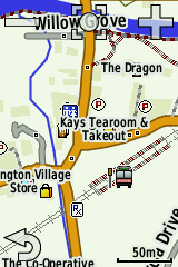
What am I doing wrong? Are the Garmin sanctioned OSM maps a different flavour? See screengrabs of identical locations on the two devices below. The Talkytoaster versions look richer, more curvy, than the Garmin ones. Is this normal?
 [img]http://thosebears.com/images/1000.png[/img]mattbeeFull MemberPosted 8 years ago
Iirc Talkytoaster adds extra sprinkles to the osm.
Having used OS maps on MM Navigator via smartphone for a long time I recently went to a Garmin with Talkytoaster maps and get on with them just fine for road use. I haven’t done any off road with them yet though so can’t comment on their accuracy in that regard.munksterFree MemberPosted 8 years agoInteresting thanks. Maybe the answer is just to use the TalkyToaster (or equivalent) maps on the SD card and not bother with the Garmin ones.
CraigWFree MemberPosted 8 years agoIt is the same OSM map data (mostly), just a different map style.
ie the Talkytoaster maps adjust the style to make lines for roads thicker, and different colours, plus different symbols for places etc. So it looks kind of similar to OS maps.
Whether it is better or not is debatable. I think the thicker roads can look messy, ie if you have several roads close together, you can’t really tell them apart.Its worth trying a few different OSM styles to see what you prefer. You can have several different maps loaded on the Garmin, and switch between them as required. And you can even create your own custom styles, though that can get complicated.
I usually use the maps from here: http://garmin.openstreetmap.nl/
I recommend the “Generic Routable (new style)”. Also the “Routable Bicycle (Openfietsmap Lite)” can be useful, as it highlights cycle paths etc.rpallenFree MemberPosted 8 years agoIf you like your 810 maps just copy it from the 810 to your PC and add to your 1000. Simples.
pdwFree MemberPosted 8 years agoThe garmin one is showing less detail and has a different style applied. The difference in detail may be down to the settings and zoom level on the device, or it maybe that garmin include less in the maps that they bundle. There was someone on the forum a while ago who made some OS-styled OSM maps, which is what I currently use on my 800.
I’ve got the proper OS maps for my Garmin but haven’t felt the need to use them for ages.
leffeboyFull MemberPosted 8 years agoI like the velomap maps for on the road and openmtbmap for off road. It’s also not to bad to style your own but you’ve got to be up for a bit of initial pain as it requires some learning.
rickmeisterFull MemberPosted 8 years agoOpen mtb maps here too and like them, don’t forget to download the contour bundle and link them up though.
njee20Free MemberPosted 8 years agoWhilst OS definitely look ‘prettier’ they’re too busy in use IMO.
timbaFree MemberPosted 8 years agoOn a small screen less can be more. The other thing to look for is whether the map can be used to search for a place to navigate to (I don’t know if the 1000 has this feature). Some maps are better at this than others
BadlyWiredDogFull MemberPosted 8 years agoWhilst OS definitely look ‘prettier’ they’re too busy in use IMO.
Depends where you are and what you’re doing with them. There’s a massive difference between micro-navigating on the Cairngorm plateau and following back lanes in Surrey.
njee20Free MemberPosted 8 years agoI fully concede that OSM lacks contours in its basic form, and I imagine the detail is more lacking oop north too as they’re open sourced, but I find OSM infinitely better for ‘micro navigating’, because you can zoom in and see where you are more easily.
I do wonder if it’s me, OS certainly has so many ardent followers (and of course if I were looking at paper maps I’d totally agree), but at the point at which paths/roads/whatever are only really accurate to +/- 100ft they’re a bit of a PITA!
scotroutesFull MemberPosted 8 years agoWithout a doubt, OSM data is all about presentation. Some of the basic options are very scant and others are much better. The inconsistency doesn’t help. Dave Barter produced a very good version that was available through the Bearbones Bikepacking forum,though it is now a little out of date.
I have noticed that the OSM maps scroll much faster on my Oregon than the OS I also have loaded.
It’s not all about detail either. Glenmore Lodge taught me that you can have too much and that 1:50k (on a paper map) was much better for micronavigation.
I’m actually going to pay for the OS-alike dataset from Talky to see how I get on with that. At least I’ll be able to see some of the tracks I’ve been contributing.
BadlyWiredDogFull MemberPosted 8 years agoI fully concede that OSM lacks contours in its basic form, and I imagine the detail is more lacking oop north too as they’re open sourced, but I find OSM infinitely better for ‘micro navigating’, because you can zoom in and see where you are more easily.
That’s the point I’m making. If you’re, say, in the Cairngorms in winter, contours might be one of your main navigational tools – you might, for example, aim to pick out a ring contour (basically a conical hump) because it’s the only recognisable feature on a snow-covered plateau.
Obviously that’s a pretty specialised situation and more a mountaineering than a mountain biking one, but it’s one of the situations where OS maps win hands down. Things are different when you throw GPS into the equation because you can get away with basic maps, particularly if you’re just following marked tracks or roads, but in pure mapping terms the Ordnance Survey produces probably the best maps in the world.
As an aside, a mate of mine who did the Spine Race last year preferred OSM on his Garmin because he felt it was marginally more accurate on a micro-level. I don’t know whether that’s really true or not, partly because he is – or at least was back then – a pretty rubbish navigator.
I’m guessing OSM scrolls faster simply because there’s a load less data to process btw. Or because the OS mapping in Garmin is vector stuff and a bit rubbish in the way it’s reproduced. Compare Garmin’s OS stuff to either ViewRanger on an iPhone or a Satmap Active 12 and it’s chalk and cheese.
njee20Free MemberPosted 8 years agobut in pure mapping terms the Ordnance Survey produces probably the best maps in the world.
Totally agree. But they don’t transfer well to digital a medium on Garmin, as you say, and as we’re discussing Garmin maps that seems pivotal!
The scroll speed isn’t the issue for me, it’s the resolution. On the 1:50k maps if you zoom in to a point where you could discern between two close paths any road is over 50ft wide, and may actually be 50ft away from where the map says it is. I’d often be riding just alongside a road, rather than on it!
I want to be able to look down at my Garmin and know where to go, or be reassured I’m on the right route. with OSM where I live (and that is a fairly significant caveat) that is very very easy. With 1:50k OS it’s a guessing game.
Edit: I CBA to link to all these from Flickr again, but look at the photos on page 1 on this, taken from my own Edge 1000 screen. The OS maps look great, from a pure ‘ooo’ factor, but to actually use them whilst riding along… No thanks.
pdwFree MemberPosted 8 years agoThe Garmin OS maps are bitmaps i.e. they’re like a photo of a map taken at a particular resolution, so once you zoom in beyond a certain point you don’t see any more detail. OSM maps are vector so you can zoom in further without loss of resolution (although whether the accuracy justifies doing so is another matter) It also means that you can get more variation in terms of how much detail is shown at each zoom level.
I seem to remember that the layout of OS maps is hand-tweaked to improve readability, which probably partly explains why the end result is clearer than OSM renderings which are entirely automated.
I think the accuracy of OSM can be better than OS, particularly when dealing with vague or moveable paths, as they’re more likely to have been traced recently by someone with a GPS, although the classification of RoW on OSM can be pretty hit and miss.
TurnerGuyFree MemberPosted 8 years agoI always find the OS 1:25k pretty accurate to where I am, esp with regard to roads.
leffeboyFull MemberPosted 8 years agoWhat do you guys that use OpenMTB maps use to plan routes?
Basecamp as well
deadkennyFree MemberPosted 8 years agoOSM depends on layers used. The cycle map is more terrain based with detailed contours and paths and bridleways emphasised, cycle paths and trails marked (some unofficial). The stock OSM is more about street detail, buildings etc.
On my phone when navigating/exploring I use 4UMaps which are OSM based and aimed at topographical outdoor use, plus are small footprint so good for offline use with no signal if you have an app that can do that. Important detail, no fluff you don’t need, and optimised for readability on mobile devices.
 [img]http://thosebears.com/images/1000.png[/img]
The topic ‘OSM maps – I'm biting…’ is closed to new replies.