
I'm looking at getting the OS app. but are their any other apps worth looking at? My cycling will be mainly on dartmoor so I'd like it to be accurate something I can plan and download a route on .
Dave
My default is now Komoot, helped by the fact that it easily syncs to my Garmin Edge and Fenix. You don't have OS mapping on it though. It does use Openstreetmap as a basis which I prefer for most cases as I can modify the OSM data when I find changes, additions etc.
Depends how much 'thinking' you want the app to do for you..
My preference is Strava route planner with heatmaps, which I think requires the preium membership.
It uses the open source mapping information which isn't graphically as nice as OS but more up-to-date. Then the heatmaps over that are even more up-to-date.
However it can't think for you so you have to learn to interpret (e.g. if there's a strong heat trace so far along a track which suddenly goes faint you can bet that's probably a hike-a-bike section). Similarly if the open source stuff hasn't caught up with the heatmap info you might need to manually plot along a section which is clearly well ridden (i.e. the route planner might not snap to it).
And finally in England I guess you would need to know what sort of track it was in case you weren't allowed to ride it (in Scotland it's the opposite, I'll flick between cycling and running heat map info to see if there's any sneaky singletrack I've missed).
In summary: best and most up-to-date information on the ground but requires user interpretation 😎
i prefer os maps, komoot and ridebygps are ok.
the os yearly sub is pretty cheap when on offer, i bought alot of paper copies with a free online map, scratch off number, if you can read a map, understand contours, map features etc, i find an os screen i can work out a track easier than say a friend with garmin who can easily go the wrong way
I bought the OS app recently, £25 for all the UK - bargain.
It also has route-planning in it which works surprisingly well, off-road too.
On the PC I use Strava and www.bikehike.co.uk
I've used Backcountry navigator for 10years+ I think there's still a 30day demo app to try it out. You can import
/export routes and it's got a route planner/creator function where you can plot and save a route. It's a one off payment and has down to 1:25k OS maps and you can download map areas for use offline.
Strava with heatmaps for me, as said above, it does require premium though. You can use Garmin Connect for free instead, though I don't think it's quite as good.
I use OS app.
I design a route, export it as a GPX and then import it onto my Wahoo gps.
Dead easy.
I also use the OS app a hell of a lot for finding other peoples walking and riding routes in areas I'm not familiar with and it's great for that.
Not quite an answer to your question but it is the answer to how I solve the same problem.
I have this process where I first find local people to follow on Strava (segment KOMs from your own rides are good for this), then you can see where else they've ridden, then you can download the .gpx for their other rides and use them as a guide to explore new areas.
I like to load the .gpx files into workoutdoors which gives me a little map on my apple watch but you could do whatever works for you.
Strava Premium for me - thankfully it seems very good no matter where I am. It's generated some good routes by itself when I've been abroad but it's very reliable for plotting your own route and it'll show type of trail and so on.
Tried Komoot when their marketing seemed to steer a lot of people towards it, found it was terrible, never used it since. Thankfully I hadn't paid them anything.
I was using ViewRanger and moved to the replacement OutdoorActive.
It's subscription based but you get full O/S maps along with others (I also use it in the USA).
The RoutePlanning works fine in the app (even the auto routing is OK with some manual intervention here and there).
It sync's automatically with my Garmin Edge device (through the Garmin Connect) with no file faffing or copying.
I use Komoot. I wouldn't say its anything better than just OK. It does weird stuff that needs you to essentially game its own planning tool into thinking you're doing one thing, if you want it to do something else. For instance, getting it to do a trad "Big Circle in the Woods" type mountain bike route is not what it was designed for, so it struggles to anything other than take the most direct (within guidelines you can manipulate) route back to the start point unless you pretend you're doing an A to B ride, and then change half way through the planning stage. It's not great at planning mountain bike routes that involve criss-crossing the same area multiple times, and woe-betide if you place a way point (even) millimetres off the route...
I've paid for an annual sub, and now there's so many routes of mine on it, I'm pretty much tied to it, but I honestly couldn't recommend it for planning just mountain bike routes, there are probably better and different tools out there that are less frustrating to use.
I asked a similar question recently - thread here
I haven't seen anything that compares with OS for mapping so I persevere with that. I found the route creation to be better than Komoot, but the route finder is painfully bad.
I did provide some feedback and was advised there is a big update coming next month. If that doesn't fix the UX issues I'll look elsewhere.
I also use the OS app a hell of a lot for finding other peoples walking and riding routes in areas I’m not familiar with and it’s great for that.
@kayak23 how do you do that? is there a way to access profiles to see another user's activities?
I have this process where I first find local people to follow on Strava (segment KOMs from your own rides are good for this)
Yes! It's great, and the better your Strava stalking skills the more you can get out if it e.g. if you click on someone's segment time it will take you to their activity where you can sometimes get useful insite into the ride (e.g. if the description mentions any good bits or some comments on something interesting).
Also if you're the egotistical kind you can see other people riding routes which look very suspiciously like one of yours and give yourself a pat on the back 😉
@kayak23 how do you do that? is there a way to access profiles to see another user’s activities?
I don't find a profile specifically like on Strava, I just tend to follow the routes of anyone I find where the route looks good. There is a rating system of 5 stars, but I find that pretty much every route ever is marked as 4 stars... always.
You just find the area you want, say Hebden.

Tap the third black dot up lower right (the little squiggle)
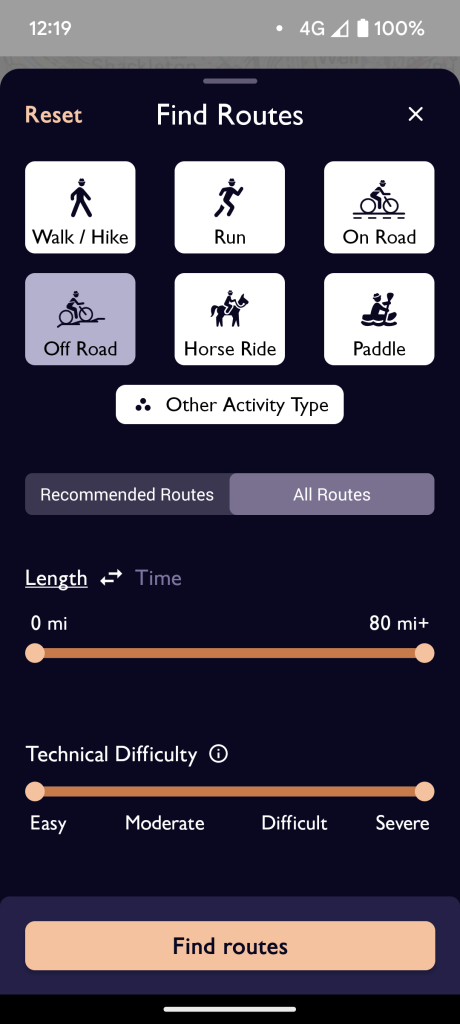
Choose your activity, and set the max distance etc if you want, then tap Find Routes.
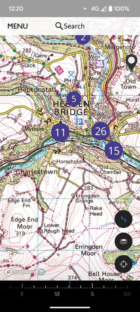
A load of dots should come up indicating the number of routes from that spot.
Click a dot and pick a route.
When you want to export it, open the menu at the bottom of the route and tap export gpx.
Name it 'something.Gpx' and save it, then upload to your device.
I use it pretty much every week for a walk in a different area with the lady person.
ahhh ok. I thought you'd managed to find a better way of browsing routes.
My annoyance with user routes is that people give them rubbish names ('day 1', '11 Jan' etc), and you can't see where they go without opening it. So essentially you've got 50+ routes to choose from in the above example, without any good way of knowing anything about them.
@mark88 OutdoorActive uses a similar technique but you can select the onscreen "Display List" button to get more info than the map displays (length, climbing, etc).
So if I got a garmin edge I can load routes from the os app. to it?, that would be handy.