- This topic has 125 replies, 39 voices, and was last updated 8 years ago by MrAgreeable.
-
Right to Roam, open Access etc
-
ninfanFree MemberPosted 8 years ago
The examples are of somewhere that before that was done was a slog through a peat bog, modified to accommodate walkers gets the boards. How do you enable horses to go through it? Bikes the same.
By that logic you would have banned walkers instead of building boardwalks
Why does massive erosion by walkers (anyone remember what the top of kinder used to look like?) justify huge amounts of spending to repair and protect, but the mere risk of bikes causing it (even though, in fact, the evidence clearly points towards cyclists self-selecting the better, more sustainable tracks) result in sheer apoplexy that it could never work?
Amazingly enough, Scotland also has some major population centres, has there been a disaster on the urban fringe? Well, they’ve certianly had problems, but those they have had seem to stem from thieving and pissed up neds camping and lighting fires, rather than from mountain bikers and horseriders.
Unfortunatley, most of Mikewsmiths objections are exactly the same ones that we heard for years explaining why open access on foot could never work…
mikewsmithFree MemberPosted 8 years agoAmazingly enough, Scotland also has some major population centres, has there been a disaster on the urban fringe?
They are not exactly that big, what I’m saying is blanket access isn’t the best or only solution, sort out the issues around it, work with land owners and agree who is going to foot the bill (not land owners)
whatnobeerFree MemberPosted 8 years agoI commend you high opinion of people.
That, and the lazyness of people. The main problem we’ve had in Scotland is neds and other eejits camping near the roads of Loch Lomond rather than bikers and hikers creating new paths or causing undue erosion.
I suspect that if there’s not a path somewhere most people will be too lazy to try and create one rather than follow the usual route.
DaveFree MemberPosted 8 years agoThe examples are of somewhere that before that was done was a slog through a peat bog, modified to accommodate walkers gets the boards. How do you enable horses to go through it? Bikes the same.
So you’re saying it was unsuitable for walkers but the idiots kept using it?
mikewsmithFree MemberPosted 8 years agoYep they did, idiots be idiots.
Part of the Pennine way – so obviously it should be fine to walk on why wouldn’t you?And as for comparisons with Scotland the population and usage is a little different

Yes it’s a Strava heatmap but it does give an indication as to the level of use currently.whitestoneFree MemberPosted 8 years ago@whatnobeer I saw some figures about Lake District visitors that claimed somewhere near 90% of them never went further than 50 metres from the road.
The heatmap doesn’t give the whole story: by far the greatest volume of data is generated by road cycling – I don’t know the proportion of mountain bikers who both carry a GPS and use Strava but I’d guess that it’s a lot less than road cyclists so there’s a bias in the data there. At the scale shown above it’s really hard to discern any use away from major roads and centres of population but go to labs.strava.com/heatmap and zoom in to one of the upland areas and you’ll see the contrast in usage. Here’s Gisburn Forest http://labs.strava.com/heatmap/#12/-2.33805/54.00297/blue/bike look in the top right corner and you see the bridleways around Malham which show hardly any use in comparison to the trails in the forest.
You could argue “build it and they will come” but there are instances of that in the Dales and the usage is still very low – the PBW was created for horse riders rather than cyclists but it’s a facility that’s there and it doesn’t get much use by mountain bikers. On this heatmap http://labs.strava.com/heatmap/#13/-2.29873/54.24667/blue/bike in the centre of the map there’s a section of the PBW that heads west from the Pennine Way. This was installed by the National Park a few years ago I doubt they’d have the cash these days.
This raises the biggest sticking point: it’s not just willingness on the part of the various parties but who pays for any improvements or changes. There was a thread on the fell running forums about the difficulty of keeping existing ROWs open and free of foliage due in part to financial restraints on local authorities.
The ROW in in England are a hotch-potch both on the ground and in law: even in a national park you struggle to link up bridleways and footpaths without using sections of the few roads in the areas. Even with the best will in the world creating such joined up routes will take a long time – look how long it’s taken to put the Pennine Bridleway together.
IdleJonFull MemberPosted 8 years agomikewsmith – Member
Amazingly enough, Scotland also has some major population centres, has there been a disaster on the urban fringe?They are not exactly that big, what I’m saying is blanket access isn’t the best or only solution, sort out the issues around it, work with land owners and agree who is going to foot the bill (not land owners)
That’s one good argument for a certain amount of devolution of government. This area ( eg S Wales) doesn’t have the same issues as the SE of England, so it shoukdnt be covered by the same blanket legislation.
mansonsoulFree MemberPosted 8 years agoMe too Frosty!
Having lived in Scotland, I just ignore piffling English access wrangling. It’s all open access as far as I’m concerned…!
DaveFree MemberPosted 8 years agoSo you want access decided on the actions of a few idiots rather than the majority? It’s an interesting proposal. 🙄
shedbrewedFree MemberPosted 8 years agoDave – Moderator
So you want access decided on the actions of a few idiots rather than the majority? It’s an interesting proposal.
Lowest common denominator policies have been thick and fast for some time now.
@Schnor; the Welsh consultation document makes interesting reading; primarily it seems to focus on addressing access to outdoor spaces for recreation in order to improve the lot of those in poverty rather than those with an ibis and a Prius. It also (importantly) notes that feedback will only be considered during this session of government and is more intended to inform the next round of incumbents of any potential for legislation reform.
As @whitestone notes with regards to heatmaps there may be little information on there from MTB users. I would say look at the empty spaces around Powys. Lots of farmland there. The Welsh Trail centres (NRW/FC/Private sector owned) are in an arc around the best road networks.antigeeFull MemberPosted 8 years agoAlways been a bit puzzled by English access law and I go back a bit ( got my Sheffield Campaign for Access to the Moors trespass runs booklet somewhere)
Can never work out how come a piece of legislation which is supposed to have the intent of giving the right of access is extensively used to define the maximum level of access when surely it was intended to be used to force landowners to give the minimum level of access that had been historically allowed.
The only damaging impact of CRoW I saw in The Peak was a proliferation of signs including plenty of “walkers only” where before nobody really knew.
I must admit to having told a Peak Park Ranger that I had the landowners permission to ride the section of Dukes Road towards Derwent Edge beyond the Derbyshire border because I was absolutely sure that every year the NT says in it’s annual report that it wants to encourage cycling on its land – the big landowners need to stop saying and actually allow open access beyond the legal minimum
ninfanFree MemberPosted 8 years agoYou make an interesting point about the National Trust
I think it’s clear to many of us that it’s time they revisited their existing approach.
DaveFree MemberPosted 8 years agoThere was a thread on the fell running forums about the difficulty of keeping existing ROWs open and free of foliage due in part to financial restraints on local authorities.
If only there was a way to get more users using them, maybe by adopting a different access model?
Yes it’s a Strava heatmap but it does give an indication as to the level of use currently.
Except it doesn’t. Unless London became an MTB Mecca without telling anyone.
Can anyone point to any evidence of an increase in erosion in Scotland post access changes? Otherwise let’s put that non concern to the side…
NorthwindFull MemberPosted 8 years agomikewsmith – Member
They are not exactly that big
Glasgow is the 3rd biggest city in the UK!
ninfanFree MemberPosted 8 years agoDave
Long report from the LRRG here, but the takeaway message regards access (page 210) is that:
Now, ten years after the legislation came into force, the Group’s view is that the new statutory framework should be judged a considerable achievement that has delivered significant public benefits and is “generally working well on the ground”. There are undoubtedly problems to be addressed in some areas as described below and there have been some prominent recent issues. However, the Group considers that these are essentially issues over implementation rather than with the terms of the legislation.
whitestoneFree MemberPosted 8 years ago@Dave As I noted earlier the heatmap is dominated by road cyclists, it would be nice to be able to filter between road & MTB.
The FRA thread was about footpaths rather than bridleways but unless there is a near constant passage of feet or wheels or hooves then foliage is going to take over pretty quickly. The bridleway (actually it’s classified as a BOAT) that goes past our house goes from clear and open to jungle in about a month and that’s with fairly regular usage by both horse riders and mountain bikers.
I looked at the Strava data for some of the classic Scottish MTB routes (Glen Sligachan, Torridon Loop, etc.) and the figures are a tiny percentage compared to trail centres, the data for classic rides south of the border wasn’t much different (Bowderdale in the Howgills has under 350 logged rides) so even when there’s existing trails they aren’t getting used that much. A quick look at times for the Bowderdale segments shows 2010 being one of the early logged rides so that’s 350 rides in 5 years. Even if just 10% of mountain bikers log their rides on Strava that still only gives 3500 rides. Compare that with somewhere like Gisburn Forest and the segments there have in the region of 25,000 attempts, by my maths 350/25000 = 1.4%. So less than 2% of a minority sport (I don’t know how many mountain bikers there are in the UK) use existing rights of way. Any publicly funded body would need a lot of convincing to put time and money in to extending and then maintaining the bridleway network.
I’m not saying that the aim of extending access shouldn’t be pursued but the financial practicalities and the glacial nature of government means it ain’t gonna happen soon.
NorthwindFull MemberPosted 8 years agowhitestone – Member
I looked at the Strava data for some of the classic Scottish MTB routes (Glen Sligachan, Torridon Loop, etc.) and the figures are a tiny percentage compared to trail centres,
Probably skewed by being in the arse end of nowhere though- compare torridon with, say, learnie trail centre and you probably get something more comparable. Or a non-purpose-built path in the Pentlands or Mugdock or something.
There might be a correlation between strava use and trail use too I suppose.
ninfanFree MemberPosted 8 years agoWhitestone, I disagree with he conclusion that a minority use rights of way, in fact the best survey to date says otherwise
DaveFree MemberPosted 8 years agoAny publicly funded body would need a lot of convincing to put time and money in to extending and then maintaining the bridleway network.
But we’re not talking extending a bridleway network…
whitestoneFree MemberPosted 8 years agoWell I contributed to that survey 😀 For me the ranges were too wide to be useful: if you rode both days of a weekend all year then you have roughly 100 days riding (I know but it makes the maths easier) so 25% is about two days a month, my trail centre usage is closer to 2 days a year, i.e. 2%.
Like I said the Strava analysis depends on the numbers of riders that use Strava so will be incomplete. But even looking at stuff in the Dales that appears in the various guidebooks you see a lot less usage than you might expect and certainly much less than in trail centres.
Perhaps a better comparison would be between dedicated trail centres and the biking centres (for want of a better term) such as Sutton Bank and the Dales Bike Centre that are a halfway house between fully signed/ maintained trails and “natural” bridleways.
It’s easy to say that I went out on bridleway X and never saw anyone but you only have to be a minute or two ahead or behind another rider and you might never see them. Short of installing some sort of bike counter or sitting at a suitable point all day you aren’t going to get complete data so have to work with what you can find.
mikewsmithFree MemberPosted 8 years agoNorthwind – Member
mikewsmith – Member
They are not exactly that bigGlasgow is the 3rd biggest city in the UK!
POSTED 1 HOUR AGO # REPORT-POST
Dave – Moderator
Don’t bring facts into it Northwind.
All one of them, one of them surrounding an area of wilderness, try England where you put 3 or 4 large cities on the border of an area of wilderness.DaveFree MemberPosted 8 years agotry England where you put 3 or 4 large cities on the border of an area of wilderness.
Where is this wilderness?
whitestoneFree MemberPosted 8 years agoI think in the case of England “wilderness” would refer to uncultivated land, perhaps not wilderness a la “Nanook of the North”
epicycloFull MemberPosted 8 years agoI don’t know anyone who uses Strava in the mountains, so I’d be wary of using it for reference. I thought it was a roadie thing.
As for paths getting overgrown, just ride them anyway. That’s how we fix them up here. Nettles and thistles are just there to remind us it’s summer, and heather is there to munch on your derailleur. 🙂
mikewsmithFree MemberPosted 8 years agoDave – Moderator
try England where you put 3 or 4 large cities on the border of an area of wilderness.Where is this wilderness?
POSTED 1 HOUR AGO # REPORT-POST
whitestone – Member
I think in the case of England “wilderness” would refer to uncultivated land, perhaps not wilderness a la “Nanook of the North”POSTED 1 HOUR AGO # REPORT-POST
epicyclo – Member
I don’t know anyone who uses Strava in the mountains, so I’d be wary of using it for reference. I thought it was a roadie thing.As for paths getting overgrown, just ride them anyway. That’s how we fix them up here. Nettles and thistles are just there to remind us it’s summer, and heather is there to munch on your derailleur.
Wilderness, that thing people use to refer to the bits of Scotland that are free to roam and really isolated.Know plenty of mountain bikers using strava, the relative imprint is important really, if you are able to think in scale and relatively.
whitestoneFree MemberPosted 8 years agoI know quite a few who use Strava in the mountains, probably at least 50% of those I ride with. I use it more to log mileage, height gain, etc. than getting KOMs (yeah right!). I’m too much of a wimp to ever trouble the leader board on descents. 😛
I think it’s reasonable to assume that if someone is using Strava (for whatever reason) at a trail centre then they are likely to also use it on natural trails. Is it accurate or representative? Phew! At the moment it’s the only real world data we have to hand. On a thread about the Snowdon BW restrictions I think it was mentioned about there being a bike counter, if so then those figures could be correlated against the Strava logs for those segments and some Strava usage amongst mountain bikers estimated.
DaveFree MemberPosted 8 years agoSnowdon being an example of mountain bikers acting responsibly and managing their access voluntarily. Something Mike points out ramblers using the pennine way are incapable of.
So let’s not judge open access by the current bad example he’s used hey? ;o)
ninfanFree MemberPosted 8 years agoWilderness, that thing people use to refer to the bits of Scotland that are free to roam and really isolated.
They’re not the only bits of Scotland where the land reform act gave new access laws to, are they?
mikewsmithFree MemberPosted 8 years agowell if you reckon it will be fine can you deposit a couple of million to cover any repairs/issues that won’t happen.
DaveFree MemberPosted 8 years agoI’m still waiting for your evidence of wholesale erosion due to open access
mikewsmithFree MemberPosted 8 years agoThere is no open access in a decently populated area, there is evidence of erosion in areas that are currently populated – such as the Cheviot stuff on the pennine way. There is a high chance that opening more will open up more problems. Hey great if it doesn’t but don’t just pretend it won’t, who deals with it if it does. Planning and legislating responsibly means you think about these things and work out what might and could happen. So who deals with issues if they arise?
scotroutesFull MemberPosted 8 years agoThe Pentland Hills are on the outskirts of Edinburgh – a town with a population 1/2 million souls. There are a couple of paths that could do with a bit extra work but the area has somehow survived the LR(S)A. The Campsies, Kilpatricks and Gargunnock Hills are similarly close to Greater Glasgow (over 1.1 Million) and are similarly coping.
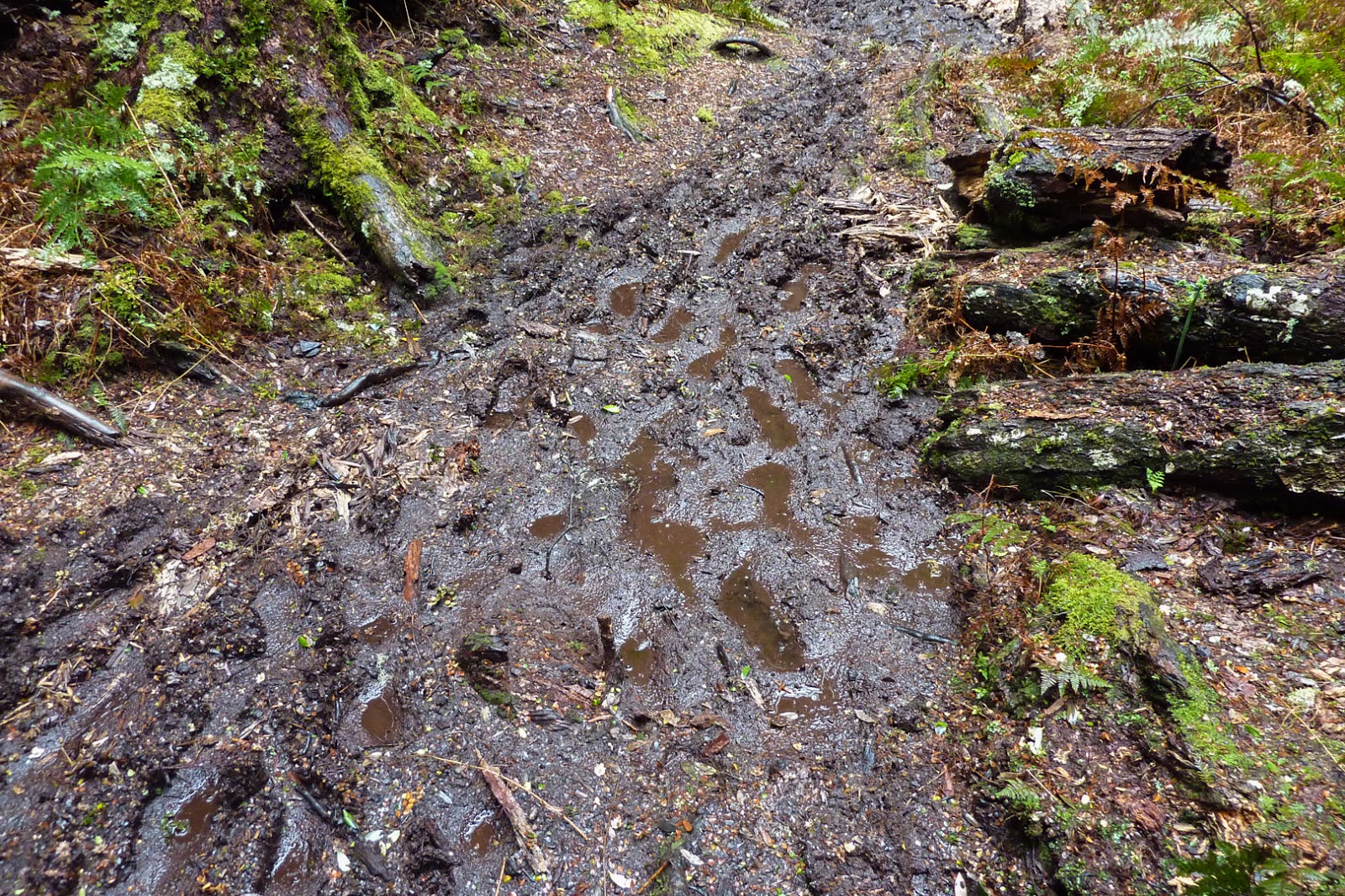
mikewsmithFree MemberPosted 8 years ago
Part of the overland track, Tasmania. Heavily regulated, walking numbers regulated no other traffic.DaveFree MemberPosted 8 years agoCool photo Mike, what are you trying to prove?
The Pentland Hills are on the outskirts of Edinburgh – a town with a population 1/2 million souls. There are a couple of paths that could do with a bit extra work but the area has somehow survived the LR(S)A. The Campsies, Kilpatricks and Gargunnock Hills are similarly close to Greater Glasgow (over 1.1 Million) and are similarly coping.
mikewsmithFree MemberPosted 8 years agoDave – Moderator
Cool photo Mike, what are you trying to prove?There are parts of the country that are not compatible with horses or bikes.
Self regulation may work in Scotland but the population is tiny. A small number of people can cause a big problem. Open access sounds awesome. Sensible access is a better idea. Again if something goes wrong the burden will fall on the land owner which is unfair. There is nobody about to do the level of trail repairs that are needed in some areas if problems start.
DaveFree MemberPosted 8 years agoThe Pentland Hills are on the outskirts of Edinburgh – a town with a population 1/2 million souls. There are a couple of paths that could do with a bit extra work but the area has somehow survived the LR(S)A. The Campsies, Kilpatricks and Gargunnock Hills are similarly close to Greater Glasgow (over 1.1 Million) and are similarly coping.
Areas next to major conurbations in coping shocker. Tweed Valley probably gets more bike traffic than most of the UK but is similarly coping. Feel free to post more photo’s from Australia to try and prove your point though…
ninfanFree MemberPosted 8 years agoThere are parts of the country that are not compatible with horses or bikes.
There are parts of the country not compatible with open access on foot, but somehow that didn’t prevent open access being introduced, or money being found to deal with it.
See Kinder Scout as an example


The topic ‘Right to Roam, open Access etc’ is closed to new replies.