I'm contemplating tackling the council about converting two footpaths into bridleways. I'm spoken to the RoW officer about them in the past and their particular situation is known about, but due to lack of any pressure (the locally active horse club(s) have been concentrating on other issues) any talk of making them more permissive is way down the priority list.
The first footpath is actually a rural unmade road with dwellings leading to a (steam) railway crossing, joining with another unmade double track which leads up to an A road.
The second footpath is directly opposite the exit of the first and is a private (I assume) metalled road which leads to several footpaths and a bridleway. Here's part of the irony of the situation – as the bridleway is accessed by a footpath, it is only technically accessible at one end on foot unless you have permission from the landowner. The bridleway then climbs up a down to join an A road, and the exit is close to another four bridleways and a byway.
The positives are it would connect a rural road to several bridleways for bridleway users (there are stables in the area), avoiding narrow and busy national speed limit A roads. For riders it's a better, safer route out of town to access the bridleway network proper.
The negatives are the landowner (or owner of adjacent farm) of footpath 2 is very anti-access, apparently recently verbally abusing walkers for using it and claiming it's not a right of way.
I'll obviously talk to RoW officers, but has anyone done anything similar, and if so what did you do show support for it?
Cycling UK are working on a campaign directed at connecting existing rights of way. It might be worth having a look at that and whether it's applicable in your examples.
Edit: it's called Missing Links
I haven't done it myself, but these guys would be my first point of call.
Great - thanks both.
Try and get the horse people on board. They have a lot more sway us at the bottom of the pile
It is hard work and takes a lot of time by interested parties and the council.
As a case study put into Google: Hampshire Wellsworth Lane footpath bridleway. You will find multiple planning documents from 2009 until the status was changed in 2015 (I think). This link is for the initial council planning kick off. www.hants.gov.uk/decisions/decisions-docs/091007-reguct-R1001095634.html
You will see that there is a need for historical precedent and engagement with multiple stakeholders including cyclists. Our opinion is no less important than horse-riders: in this case it was provided by the CTC (now Cycling UK).
As above, I think Cycling UK is the best place to start.
I would suggest you don't bother. Just ride on it and be polite if questioned. Seems a lot of effort to solve a non-existent problem.
In my 35 years of riding cheeky I think I've been moaned at about 4 or 5 times and I ride cheeky pretty much every single time I ride. Its such a non issue I do think all the fuss about turning footpaths into bridleways will shine a light on something we can carry on doing pretty much un-hindered. I'm always more concerned that we we end up being regulated to cycle paths with number plates attached for forced to ride only in trail centres.
https://maps.nls.uk/view/101442360
This 1942 map would indicate the route from Ashey station to the old water works (where the bridleway begins) is an old road not a F.P., so has the same status as the main Ashey Road.
Just because a PROW is signed as a footpath, it does not mean that that is the highest level of access allowed, it just means that only a footpath has been proven, so far. This map is a good basis to push for a BW.
I assume you're thinking of others here rather than yourself. If it were me I'd just ride it and if the landowner piped up that could be the point to go down the legal option.
I would suggest you don’t bother. Just ride on it and be polite if questioned
This ^^^^^^^
This 1942 map would indicate the route from Ashey station to the old water works (where the bridleway begins) is an old road not a F.P., so has the same status as the main Ashey Road.
Just because a PROW is signed as a footpath, it does not mean that that is the highest level of access allowed, it just means that only a footpath has been proven, so far. This map is a good basis to push for a BW.
Thanks. That's a very good point.
I assume you’re thinking of others here rather than yourself. If it were me I’d just ride it and if the landowner piped up that could be the point to go down the legal option.
Unfortunately the landowner is piping up. Not officially, but he is being aggressive toward people on the road. If it can be officially recognised then there may still be confrontation, but the landowner's argument would be totally null and void.
Missing Links suggestion now made and council contacted.
I would suggest you don’t bother. Just ride on it and be polite if questioned
Last time I came across the guy I thought I was going to have my first punch-up in years. And I was being polite. 😉
It is illegal to obstruct those using a right of way so if a landowner tells you it is not a right of way, get off my land etc. then report it to both the police and the ROW officer. If persistent then they may take legal action. If the ramblers find out then they will get stuck in and walk across his land as much as possible.
If it is an ex road it may be worth asking the ramblers as they are currently trying to unearth lost routes so although some if the can be anti bikes if it is a metalled lane with an awkward landowner then extending access could make walking use more secure. It can be am important distinction that old lanes remain bridleways.
Also there should be a local access forum run by the council that you can invite yourself along to. Turn up showing better connections, this is a road on old maps, can we get it upgraded. Could be worth a shot.
https://dontloseyourway.ramblers.org.uk/
I would suggest you don’t bother. Just ride on it and be polite if questioned
Nope. Push for the access as advised here. Otherwise we'll never get any improved access for riders now or in future.
The logic/sense in a change is unfortunately of zero relevance or help for a change. For a legal change you need to show it is misrecorded, the old map above would be great for this and or show evidence of use over 20 years. The other option is a permissive change but that needs a willing landowner.
Good luck but don't expect it to be quick, could easily take 5 years at the moment with all the 2026 ROW cut off date claims going in.
I stand to be corrected, but as far as I am aware the law does not criminalise cycling on a footpath.
Byways and Bridleways trust
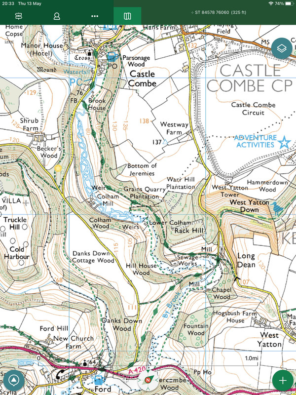
There are odd situations where a bridlepath becomes a footpath at a parish boundary, due to the way different parishes interpreted the use when laws were introduced in the 1960’s. There’s one example that I’ve cycled regularly in the past, a route running from Castle Combe to Long Dean, which would clearly have been a bridlepath in the past due to there being both farms and mills all along the Bybrook valley, going back centuries.
You can see where usage changes in the centre of this screenshot just below Grains Quarry Plantation:
Here's one, BW to FP at a random point on an otherwise okay descent above Yew Cougar Scar (if the link works. . There are others close by that are equally daft.
https://www.streetmap.co.uk/map?X=391412&Y=469642&A=Y&Z=120
I just ride this stuff but it puts a lot of people off.
I stand to be corrected, but as far as I am aware the law does not criminalise cycling on a footpath.
This is usually true unless there is a local bylaw that does criminalise it.
For example the footpaths on the land owned my the Malvern Hills Trust. That’s a £500 fine. To my knowledge, no one has ever been prosecuted though. They have allowed permissive use on a few of them to make their three signposted cycle routes viable, but can obviously remove such permissions.
A local cycling club in Buckinghamshire is seeking to have a footpath upgraded to bridleway status (it's actually a tarmac estate road, used for many years by cyclists). The landowner has decided to stop cyclists using it. Buckinghamshire Council have advised that they have a backlog of cases going back to 2015. Even if and when they decide to grant the upgrade the landowner has a right of appeal. So I wouldn't hold your breath.......
I'm kind of 50:50 on this.
Part of me thinks that the proper way forward is to put the case to the council ROW, engage with the relevant people and so on.
Part of me thinks sod it just ride it anyway.
Option (a) can take YEARS and in some cases it simply serves to highlight to an absent landowner that people have been riding it anyway for ages and the "I'll show them" mentality kicks in and it drags on for years more through court cases. Councils now are so woefully underfunded that ROW is one of the areas they massively cut back on (plus it's not a vote winner) so there's a backlog of cases going back a decade.
Option (b) is generally fine and it's quite amusing that in most cases, the only reason people can think of for you NOT to ride it is "because it's a footpath". Nothing to do with erosion, privacy, convenience, the wider access network or anything, it's just "this is a FP". Change a couple of signs and suddenly it's fine to ride... WTF?!
Anyway, by continuing to just ride it no matter what, you're continuing it's usage as a de facto BW which helps the case for Option A. So both approaches work together!
@Squirrel I'm being nosey, where abouts in Bucks is the footpath you mention?
Currently mashing exactly these problems in my area as part of the 2026 cut off. I’ll have a proper look over the weekend but first glance says great candidates for ‘DMMO higher rights’ (aka conversion to BW). Those with ****ty landowners go to the top of my list.
@crazy-legs agree on A vs B but we owe it to our kids to have this stuff properly recorded. However option C that is the long game is Scottish rules - https://www.scottish-orienteering.org/resources/access/access-to-the-countryside-in-scotland/
@jeffl It's from Upper Winchendon to the Eythrope Park Gate on the Waddesdon Estate.
A local cycling club in Buckinghamshire is seeking to have a footpath upgraded to bridleway status (it’s actually a tarmac estate road, used for many years by cyclists). The landowner has decided to stop cyclists using it.
This is the problem - locally to me, I helped some horse riders with evidence for a FP upgrade claim. The route gets used frequently by horses and bikes. The response of one of the landowners was to threaten to lock gates, apparently. I imagine that, in the face of an upgrading claim, many landowners will want a visible sign that they are exerting their rights, even if they've turned a blind eye for years. Or just out of spite for having to deal with the paperwork.
And there is no guarantee that upgrade appeals will work, obviously. The example Johnx2 highlights above (Monk's Road into Arncliffe), was subject to a big push for upgrading a decade ago. The attempt was unsuccessful, and IIRC, a section of the existing BW was actually downgraded!
No reason not to try, especially if the landowner is already being an arse, I guess, but using this process may make things worse in the short to medium term.
If PROW cases are taking several years to progress, perhaps in the case of active landowner opposition, it's time to provoke them to take legal action. When the day in court arrives, the evidence of historical BW access can be presented. It needs someone with the spirit of the Kinder Scout trespassers to adopt this approach!
It needs someone with the spirit of the Kielder trespassers to adopt this approach!
I tried trespassing at Kielder once, but the landowner's midge army saw me off. 🙂
EDIT: Nice quick edit!
@Squirrel Thanks for the update. Bit away from me I used to be based in the High Wycombe area. From memory Waddesdon is managed by the National Trust, not sure if they own it though.
Either way Ride Sheffield/Peak District MTB have a good relationship with the NT as they've worked with them on access through the Longshaw Estate in the Peak District. May be worth speaking to them to see how they worked with the NT.
From memory Waddesdon is managed by the National Trust, not sure if they own it though.
Eythrope I believe belongs to the Rothschilds. I don't know the background to this but I've cycled there myself having missed the signs to the parallel bridleway and met the landowner (Lord Rothshchild, for 'twas he) in his car coming the other way. Expecting a telling off I instead got a cheery wave and a smile which I took to be the owner's consent to be there; they even opened the electric gates at the top for me. One wonders whether anyone engaged with the landowner before putting the application in, because to an outsider this looks a bit like a version of "can I ride down your drive?" "yes, of course, be my guest" vs "I demand the right to ride down your drive" - to which the answer is always likely to be "sod off, use the bridleway".
I don’t know the background to this but I’ve cycled there myself having missed the signs to the parallel bridleway and met the landowner (Lord Rothshchild, for ’twas he)
I was there last week on my road bike. First time there in many years and the gates are properly secure now - they need a combination on both sides and there are no gaps to squeeze past.
Just to sure, a busy body got in her car and came chasing after me from one of the local houses to let me know there's no access. I presume the gates have CCTV that warn of 'intruders'.
My fault for not checking, but you can see from the the Strava heatmap (from where I planned my route) that is has been used a lot by bikes in the past.
I'm all for getting that fully tarmac'd road classified as a b/w. Will sign up!
Without that link the alternative routes are pretty hopeless for cyclists.
You should be looking for a historical precedent here, i.e. its provided public access by horse in its life. Primary sources of evidence as to its classification
1. It connects to a railway so there will be railway survey records about its use and maintenance and the relationship to and access for the station
2. The 1910 Valuation Office records which aren't digitised for the area in question. They'll often indicate the land usage for the purposes of valuation / taxation (hint - landowners didn't want to be taxed on routes across their land). Walled routes like the one you show are pretty much a cert - http://labs.nationalarchives.gov.uk/maps/valuation.html
3. Historical map data will often show how a route has evolved into what it is today - https://maps.nls.uk/geo/find/marker/#zoom=15&lat=50.6973&lon=-1.1854&f=0&z=1&marker=50.6964,-1.1842&from=1550&to=1970
To me it's plainly evident that there was a route to the station from north and south. The purpose of the station was to get people and goods to the port and prior to the motorcar, how else would it be realised? Don't pitch this as an upgrade but a restoration of previous higher access rights.
I'd also ask do you get challenged riding from the landowner (not red socks)? This has all the hallmarks of a route that you could ride at will so I'd only go to the trouble if you either want to take them on, or are keen to 'Restore the Record' ahead of 2026.
There's one near me that's got a modification notice on it at the moment. The original application was made in 1991.
It's currently a restricted byway that turns into a footpath half way along its length. If it goes through, it'll become a BOAT, which seems ridiculous given the nature of the route. Having read up on some of the history, it's clear that common sense has absolutely nothing to do with this process.
Common sense isn't the same as historical precedent. And regarding the glacial pace of these applications, each local authority will be different - some will be even worse... There are quite a few around us dating back to the 90s (Kirklees, West Yorkshire).
Good luck but don’t expect it to be quick, could easily take 5 years at the moment with all the 2026 ROW cut off date claims going in.
Great. Although what I expected TBH.
A local cycling club in Buckinghamshire is seeking to have a footpath upgraded to bridleway status (it’s actually a tarmac estate road, used for many years by cyclists). The landowner has decided to stop cyclists using it. Buckinghamshire Council have advised that they have a backlog of cases going back to 2015. Even if and when they decide to grant the upgrade the landowner has a right of appeal. So I wouldn’t hold your breath…….
That sounds pretty similar to what's happening here.
I’d also ask do you get challenged riding from the landowner (not red socks)? This has all the hallmarks of a route that you could ride at will so I’d only go to the trouble if you either want to take them on, or are keen to ‘Restore the Record’ ahead of 2026.
Thanks Scuttler. Yes, he's aggressively challenged me and several others, including walkers and families. Being brutally honest I just want to cut potential confrontation with the landowner by not giving him a leg to stand on. Realistically he'll still find something, but the less ammunition he has...
Option (b) is generally fine and it’s quite amusing that in most cases, the only reason people can think of for you NOT to ride it is “because it’s a footpath”. Nothing to do with erosion, privacy, convenience, the wider access network or anything, it’s just “this is a FP”. Change a couple of signs and suddenly it’s fine to ride… WTF?!
A green post was the basis of the landowner's argument - my 'let's look at a map' wasn't even vaguely entertained.
Anyway, by continuing to just ride it no matter what, you’re continuing it’s usage as a de facto BW which helps the case for Option A. So both approaches work together!
Well, one of the footpaths at the end of the road is apparently a lot more fun than the bridleway, but if it means having to use the bridleway for a while then so be it. 🙂
Yes, he’s aggressively challenged me and several others, including walkers and families. Being brutally honest I just want to cut potential confrontation with the landowner by not giving him a leg to stand on. Realistically he’ll still find something, but the less ammunition he has…
OK so use has been interrupted. Can you find lots of people willing to give evidence that they have had use of the route, uninterrupted, for 20 years?
If the answer to this is yes and you're happy to get involved in a long laborious process then contact your ROW officer and let them know you want to submit a DMMO claim.
You will need local ramblers and horse riding groups onside to have a chance of success as the burden of proving the 20 years use is on the claimant.
Last time I came across the guy I thought I was going to have my first punch-up in years. And I was being polite.
Do you think that 1. He'll be happy if his (presumed) objections to a Bridleway are ignored/overruled? 2. is going to be polite either during the consultation/decision process or afterwards? 3. during any decision making he might be more obstinate to emphasise his point that you have no current rights...
Not saying you shouldn't pursue it but in my experience, irrational people are rarely made more cooperative by a process that does something they don't like, even if that process is fair and reasonable.
Personally I'd focus my efforts on government for a national approach rather than one path at a time.
Personally I’d focus my efforts on government for a national approach rather than one path at a time.
Sadly a lot of the worst landowners are Tories, Tory donors and/or part of Government so there is a vested interest in keeping things just the way they are.
Knocking around within that statistic is ownership by Forestry Commission, MoD and Crown Estate (together the three largest landowners in the UK) which is all basically Government (in one form or another...)
If anything, with the recent trespass bill, they're looking to restrict rights even more.
You will need local ramblers and horse riding groups onside to have a chance of success as the burden of proving the 20 years use is on the claimant.
Which is why historical evidence may be better than going down the recent usage route. And the sources and methods are applicable to all the other seemingly downgraded footpaths in your area.
Can you find lots of people willing to give evidence that they have had use of the route, uninterrupted, for 20 years?
Short answer: I don't know.
Do you think that 1. He’ll be happy if his (presumed) objections to a Bridleway are ignored/overruled?
Not at all.
2. is going to be polite either during the consultation/decision process or afterwards?
Again, I seriously doubt it.
3. during any decision making he might be more obstinate to emphasise his point that you have no current rights…
I fully anticipate that he would be.
Not saying you shouldn’t pursue it but in my experience, irrational people are rarely made more cooperative by a process that does something they don’t like, even if that process is fair and reasonable.
Yes, I agree.
I suspect in this instance the particular roads in question are actually public highways that just happen to have a green sign at the end, and obstructive farmer would argue that blue is red until it's time to bring the cows home. Hopefully that changes how difficult it would be to get access formally approved by RoW as technically it's already there (but I'll believe it should it happen).
However, it's common knowledge signs on the ground can be incorrect so it's a pretty flimsy basis for an argument. But, as so much depends on this particular sign I imagine where I'm ultimately going with this is I'd like it changed (not removed, as that would open a whole new can of worms) and the legality of access put beyond reasonable doubt.
(Although as he's now apparently having a pop at walkers it's arguable...)