And don't say "Thirlmere" 🙃
After seeing that United Utilities want to refurbish the Haweswater aqueduct I've gone down a bit of a rabbit hole reading into the history of these pipes.
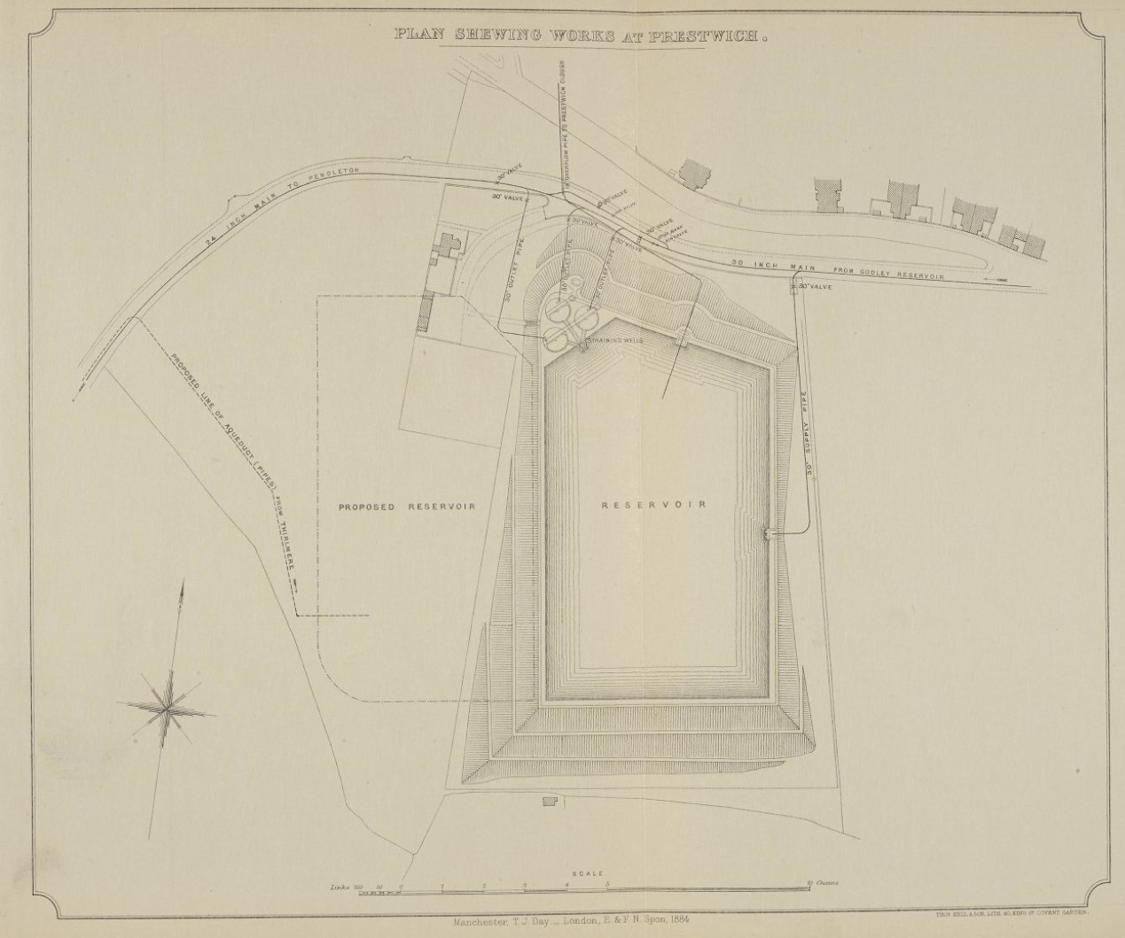
Anyway, long story short, I can't find out exactly where the Thirlmere one ends. Does anyone know? Haweswater ends at the Heaton Park reservoir, but the best I can find out for Thirlmere is according to this map it ends in the middle of nowhere halfway along Butterstile Lane.
Someone on here must know!
Looking at the line on the map, which at one point passes under 'Thirlmere Avenue', unless I've mis-read it, it ends up at Audenshaw Reservoir.
EDIT: You piqued my interest...there used to be a covered reservoir at Butterstile Lane. By the looks of it on Google maps, there is a suspiciously new looking housing estate where it would have been.
Back in 1976 I was a young graduate civil engineer with consultants Husband and Company in Sheffield. I spent the winter of 1976 hanging under Boothferry Bridge near Goole knocking off lumps rust and measuring what was left. It was pretty cold and miserable. Fast forward a few months and one of the partners, Alan McCartney, called me into his office and said "I hear you're a chap who doesn't mind a bit of physical discomfort". "Depends what you have in mind Mr. McCartney" I said.
It turns out the discomfort involved an internal inspection of part of Thirlmere Aqueduct near Agecroft where there were concerns around coal mining subsidence. We entered at Butterstile reservoir (mentioned above) and made our way towards Agecroft. I should point out that both reservoir and pipeline were empty (well almost it turned out). We had with us engineers from NW Water and the NCB who supplied helmets, lamps, kneepads and some natty little trolleys which we could scoot along on, gradient permitting.
We were inspecting the run lead joints between the 40" (I think) cast iron pipe sections to see how much they had been pushed together or pulled apart by the surface wave caused by subsidence. One of the NCB guys went ahead on a nice downhill section and we heard - Splash "Aagh". There was a drain valve at the low point but not all the water had been drained! 20" of water in a 40" pipe! I tried in vain to get through without my wellies getting full of water but no luck. I remember at the end of the section we were looking at leaning up against a gate valve eating a Mars bar. It occurred to me that just the other side of that valve was a head of water leading up to Thirlmere.
Anyway, here is Thirlmere Aqueduct on Open Street Map You will see it splits at Walkden, the Northern spur heading through Agecroft to Butterstile Res. and the Southern spur going around Manchester City Centre to end at Audenshaw reservoirs. Here's a nice little talk given to members of the Manchester Geographical Society in 1888.
That's a great tale of engineering inspection slowoldman!
Thanks Slowoldman. Quite enjoyed your story and link to the ye olde presentation
The company I worked for (many years back) did the refurb for UU of Thirlmere
Very interesting fossy.
according to this map
Neat map. I've just been lookin at the national library of Scotland, nls maps following the route of the pipe 1888 - 1915.
https://maps.nls.uk/geo/explore/#zoom=15.4&lat=53.73822&lon=-2.60131&layers=6&b=1&o=100
Very amusing tale, but were mars bars really bigger back then?
Interesting looking at those historic maps that Butterstile Lane changed its name to Garner Road and back again.
Oh and yes, Mars bars were DEFINITELY bigger 50 years ago.
I always say our "corporation pop" is finest cumbrian spring water (I live near the end of the Thirlmere aquaduct)
Just about to start work on the environmental aspects of the HARP / Haweswater refurb...110km long.
Is it coincidental that opposite the end point of that route of the pipe is an area called Drinkwater Park?
Thanks Oldman,
Thats a really interesting story.
According to google
In the late 1970s, a Mars bar weighed around 57 grams. Over the years, the weight of a Mars bar has fluctuated, and in 2023 it was 51 grams.
Further googling also found in the mid 1980s the weight increased to 67g
On a slighty different note, Im always intrigued by the Whittle Dene watercourse which supplies Newcastle & Gateshead water supply from Catcleugh Reservoir (next to the A68 below Carter Bar) via the River Rede then various aquaducts and other reservoirs to Tyneside.
I posted this and promptly forgot all about it 🙄
Thanks all! Some fascinating stuff here.
Looking at that ^^ OSM map and reading here (about 3/4 of the way down) that a) Butterstile reservoir no longer exists as suggested by @martinhutch and b) it used to go to Heaton Park reservoir but doesn't any more, it looks like that whole northern branch after it splits at Walkden is no longer in use? So it only goes to Audenshaw now?
Even more curious now. I think I might contact UU and see what they say. Will post back here if I hear anything!
Edit: More mystery: That link also says that Heaton Park reservoir is no longer used for drinking water and is only used for handling water while maintaining the local aqueducts. If that's so, then where is the drinking water from the Haweswater aqueduct stored? The plot thickens...
Erm, nonsense reply deleted.
OK I've done my "due diligence" now. As you said, there is a major project to restore large sections of Haweswater Aqueduct, The Haweswater Aqueduct Resilience Programme
If you take a look at that and the interactive map you will see that the restoration works end near Bury. To the east of the M66 and north of Rochdale Old Road is a large service reservoir and water treatment works (Woodgate Hill).

My bet is that's where the aqueduct ends now.
You need Martin zero on YouTube…
Great shot of Thirlmere, erm Wasdale, there.
I think I might contact UU and see what they say. Will post back here if I hear anything!
Someone at UU called me back about this today: they can't tell me anything re. locations or what is active because security. Go look at the HARP website for info.
☹
