
Apparently conditions will be right for this this week.
Actual Experts, internet jocks and TJ please explain/discuss.
It's just a media phrase for some stormy conditions, makes it sound all dramatic so people panic buy, post pictures of a tree fallen over on internet forums and most other people carry on as normal.
i think i just rode home through it.
pretty wild down here in the peninsula.
I can only give you a quiet storm
Oh and if it's in the South or Scotland then it'll make the news,
Bondi, yesterday
[img] 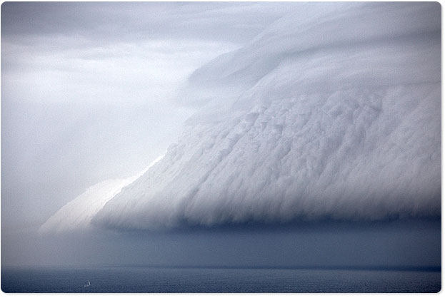 [/img]
Now THAT's a storm.
We've been promised ThunderSnow this week!!
That's excellent Cap'n.
Oooh Thundersnotorm.
"Medja gharbidge" for Autumn Storms (all be it a bit late)
Looking forward to some solid swell and 4mtr weather here on the blustery SarfCarst.
high spring tides and low pressure = storm surge, see 1950s East UK and the low countries here:
http://en.wikipedia.org/wiki/North_Sea_flood_of_1953
Perfect storm? Nah. The term was coined in the book of the same name to describe a storm where, IIRC, two large storm fronts combined to create almost unprecedented contitions. This is just a big low pressure area followed straight after by a second one. Get yer kites out, take advantage.
Perfect Storm?
Ah, George Clooney and Mark Wahlberg at their finest.......really!
The storms we get/are getting are depressions (cyclonic). They start across the other side of the Atlantic as waves on the Polar Front (where cold air from the north meets warmer air from the south).
The coriolis force causes it all to spin anticlockwise, with the warmer air rising up the warm front and being forced to rise up the cold front. This rising air causes low pressure (which becomes the centre of the storm), and cloud and precipitation along the fronts. Air rushes into the centre of low pressure, giving strong winds. As this happens, the fronts meet at ground level to become occluded and the storm dies out.
Perfect storm = well defined fronts, rapid convection (driven by the PF Jet stream), giving very low air pressure in the centre 950mbish, strong winds and sudden, torrential precipitation.
[url= http://www.bbc.co.uk/weather/features/16143615 ]storms ahead (occluded)[/url]
high spring tides and low pressure = storm surge, see 1950s East UK and the low countries here:
Spring tides have just passed and weren't perigean and the low is moving in the wrong direction to cause much of a flood, if any. But apart from that... 3/10
I sat on my patio in North Queensland when a Cat 5 cyclone passed over. Just shifted ourselves around to the other side when the eye passed over us.
Really quite eery, but highly entertaining watching anything not tied down go flying.
There's a lot to be said for a properly engineered house. 🙂
The storms we get/are getting are depressions (cyclonic). They start across the other side of the Atlantic as waves on the Polar Front (where cold air from the north meets warmer air from the south).
The coriolis force causes it all to spin anticlockwise, with the warmer air rising up the warm front and being forced to rise up the cold front. This rising air causes low pressure (which becomes the centre of the storm), and cloud and precipitation along the fronts. Air rushes into the centre of low pressure, giving strong winds. As this happens, the fronts meet at ground level to become occluded and the storm dies out.
...or it could be one of these.
[img]
 [/img]
Perfect storm = well defined fronts, rapid convection (driven by the PF Jet stream), giving very low air pressure in the centre 950mbish, strong winds and sudden, torrential precipitation.
The center of the low as it tracks across Scotchland will be C950mb.
According to XC weather Pressure Map
http://www.xcweather.co.uk/GB/forecast
Click PRESSURE Tue 1500
We've been promised ThunderSnow this week!!
Had a bit of that last week in Ayrshire, it was nice
CFH, Coogee beach (Sydney) in a Perfect Sand Storm
[IMG]  [/IMG]
Awesome! Forgot to credit the rather excellent Aquabumps for my pic.