[quote=schrickvr6 ]it seems quite compelling.
To a conspiracy theorist. Not read anything apart from the URL on the basis that 90%+ of stuff like this in FB is conspiracy theory, but the fundamental flaw on the basis of the URL is that the semiconductor folks on the plane weren't all that high powered and just a handful of the thousands in the company.
I thought under your theory they pulled all the plugs and lost everything?
I do not have a theory, not enough evidence. I raised those points to show you what is possible.
I do not have a problem with the suicide theory. I'm just pointing out that aircraft are complex and designed with many failsafes in mind. Hence the likely hood of an outlier (or what you call implausible) event causing the crash is quite high, whether thats pilot suicide or a perfect storm of failures is going to be tough to determine.
PS I think you misunderstand William of Ockham slightly.
Once again I am underwhelmed by the quality of the "debris" finds, these look like waves, taken on a stormy day. No wonder they cannot find anything, seconds after these images were tken the "debris" ie froth has dissapeared. taken from [url=
of Transport Malaysia's facebook feed.[/url]
[img]  [/img]
I think you are going to have to assume that these images have been studied by people who are used to analysing satellite photos.....
And the quality of images they have will be far higher than what they release to the public.
Its not the quality of the images, its the fact that it just does not look like debris any more than the millions of white things in all the other satellite images of other regions. Spend an hour on tomnod looking at the sea, there is shed loads of white stuff like this.
And to the untrained eye, a bike is a bike is a bike. 😉
Before you assume/accept that I am a pillock and have no idea what I am talking about, just do as I ask and spend some time on tomnod and see what you find in the ocean. Loads of images like those ones.
Before you assume/accept that I am a pillock...
Nah man, I respect your point of view - but I don't think there's any value in me going on tomnod and having a scout. This isn't like keeping an eye open for a missing cat, I ain't gonna have a clue what I'm looking at - it's not like the plane's gonna be floating there with people waving frantically at the passing satellite.
I don't think you are a pillock, but I do think you are a bloke browsing the internet who is seeking to pass judgement on the work of professionals.....
The chinese and Malaysian professionals thought this was it did they not?
Just because someone has a job and a title doesn't neccesarily make them experts. I'm just applying a bit of skepticism.
[img] 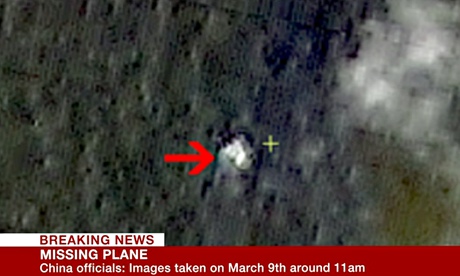 [/img]
Has [url= http://www.eutimes.net/2014/03/malaysia-airlines-suspicious-cargo-destroyed-in-massive-new-mexico-explosion/ ]this[/url] been done yet?
Looks legit Bazz
The GRU had previously, on 14 March, reported their “puzzlement” as to why the United States Navy “captured and then diverted” this Malaysia Airlines civilian aircraft from its intended flight-path to the Diego Garcia atoll, an assessment that has subsequently been verified by radar tracks showing the mysterious US military flights moving about this aircraft immediately prior to its “disappearance.”
😉
Thats some crackpot conspiracy theory there!
What puzzles me is why these nutters thing that if the US miliatry had something so valuable/important that they would be willing to hijack a plane to get it back that they would just load it onto a civilian container ship with only 2 seals to protect it.
Mental.
Has this been done yet?
Someone put a lot of time into putting that "theory" together.
The "photo second right" was from one of the long-ago, above-ground nuclear weapons tests, likely at either the Nevada Test Site or in the S. Pacific, (i.e. Eniwetok or Bikini atolls)---long before the cruise missiles depicted in the photo even existed.
I live in New Mexico and the purported massive explosion hasn't been reported by any news agencies in the state.
Before you assume/accept that I am a pillock and have no idea what I am talking about, just do as I ask and spend some time on tomnod and see what you find in the ocean. Loads of images like those ones.
Do we think satellites only work in the visible spectrum? Might they work in different frequencies that are capable of highlighting differences in, say, material densities, and be able to differentiate between, say, metal and seawater?
I'm no satellite expert, but I used to work in a field where all manner of images were produced (tranmission electon microscopy and associated techniques), if I stuck my results on a website you'd probably completely misinterpret them. No ones saying youre a pillock, just having a debate.
Infred does temp. Any bit of aircraft that has been in the sea for more than a few hrs will be the same temp as the sea.
I am not an expert in satellites, I know a little about it through a previous job, but not much. I am fairly sure we have, as yet, to develop an optical method of measuring density. There is XRF to do elemental analysis, but I don't think satellites send Xrays (yet). (I could be wrong).
There is satellite based radar for interferometry purposes, used fro topology mapping. I do not think it could detect half submerged moving around stuff though.
There might be other methods, but we would have heard about it, the reporters are desperate to find a new way of explaining this. The images released are optical,and it is inferred that the "debris" has been spotted optically.
What I am not sure about is I think that the observation satellites are making passes, so they only take one image, and then on to the next sector. So they cannot discriminate if an object appears/disappears (ie the white tops on a wave). If they could take lots of images of one spot I think we would have seen them too. But I am not 100% sure about this..
There is also the issue of resolution, I am sure that the best resolution MIL sats have is about 0.3m, which is the max resolution we are seeing on all those images. it does not get better than that.Commercial resolution is about 0.5m which is probably what most of the of the images are.
Until something is found, it is just "possible debris". The fact everybody is in this one area says they must be fairly confident of it.
Most satellites aren't taking snapshots but scanning along track. Transients such as whitecaps wouldn't persist for long enough.
[quote=Bazz ]Has this been done yet?
Thanks for that - I needed a good chuckle.
its the fact that it just does not look like debris any more
My friend's dad (yes, I know...) spent 30 years doing aerial reconnaissance for the US military. The exercise is, apparently, a bit more involved than just having a quick glance at a couple of photos online.
Guess what?
does not equal satellite images. Aerial recon mostly involves the correlation of imagery with electromagnetic sensor data, such as radar, infra red, radio etc. So far Aerial recon has spotted very little of what the satellite images purport to show.aerial reconnaissance
My two theories:
Onboard fire/pilots overcome.
Hijack intent or trying to aim for US base. Shot down.
But that doesn't explain why the aircraft was turned away from any safe landing area and flew for hours with no attempts to communicate before perishing. And a fire on board the aircraft would have brought it down much earlier. The only theory that fits for me is suicide. One pilot took out the other and the aircraft flew for hours with the passengers and crew blissfully unaware until it ran out of fuel. If they were in trouble Why turn right and aim for a remote US base hours away rather than turn left or completely around and and have several suitable landing strips within quick flight time away?
Deliberately aimed at the base?
Silence and misinformation on location/radar before?
Someone knows something. In this day and age for a plane to 'vanish'?!
I think it highlights how out of touch the regulators are. Why do we still have 'black boxes'? If the engine suppliers can monitor engine health in real time, plane status and position can be.
The engine monitoring system works thorugh the aircraft ACMS system and data is transmitted via ACARS, so there is no independant engine monitoring system and the system doesn't continually stream data. Only the very latest aircraft (B787 and maybe A380's) could possibly be capable of doing this assuming there was a global network out there capable of receiving the data being streamed from the aircraft - and storing and managing it. The aircraft was not where it was supposed to be - the regulators are entirely focussed on safety of the operation of the aircraft under normal operational circumstances. They don't have a mandate on the security aspect of the aircraft - maybe they should in this day and age. If someone deliberately wanted to lose an aircraft then clearly it is possible to do so. This is why I personally think that this was done deliberately by one of the pilots rather than a hijacking or technical problem.
If you wanted to lose an aircraft then the middle of a vast empty ocean is the best way to do it. The pilot obviously knew this.
Aerial recon mostly involves the correlation of imagery with electromagnetic sensor data, such as radar, infra red, radio etc. So far Aerial recon has spotted very little of what the satellite images purport to show.
It involves looking at stuff from above.
But I'm glad we are agreed that it's more involved than just clicking on a few website images.
yeah I don't think I do agree, Aerial recon is not satellite imaging.
I'm just skeptical, that's all. If you want to believe in some fantasy world they "they" know everything then do go ahead.
So far loads of false conclusions have been drawn in this investigation.
All I want to see is evidence, if they find even 1/10th of that imaged "debris" anywhere near the area where it was spotted and prove it is from mh370 then I will be happy. I am not saying it is not, I'm just saying the evidence is thin.
I think it highlights how out of touch the regulators are. Why do we still have 'black boxes'? If the engine suppliers can monitor engine health in real time, plane status and position can be.
I rather think the complete lack of any physical evidence of what's happened to MH370 rather reinforces the necessity for black boxes.
yeah you have to hope that from now on there will be some kind of cloud storage of FDR and CVR for the whole flight.
the latest report is of a debris field of 300 objects up to 15m in size from a thai satelite
[img]  [/img]
also the earliest reports of debris were from a french [u]satelite using radar[/u] not just visual
yeah you have to hope that from now on there will be some kind of cloud storage of FDR and CVR for the whole flight
and then you'd have a bunch of theories about the data being hacked or spoofed.
The pilot suicide theory seems the most plausible theory but it does still have some pretty big holes in it still. Once the suicidal pilot disables the other would it not be more simple to either 'jam the sticks forward' and stuff it into the ground/sea as opposed to flying aimlessly south until the fuel runs out. Maybe he just wanted to see some penguins.
It's one hell of a difference between wanting to kill yourself and wanting to kill yourself and 200+ other people. Is there any indication that he was a psychopath?
Pilot suicide- then why keep flying for hours?
It still points to incapacitated pilots or pilots hijacked- forced to keep flying? In alot of cases of hijack the pilot is forced to keep flying whilst the hijacker dithers or considers options? The Ethiopian plane that crashed into the sea was one where the hijacker dithered/changed mind on where to go and the plane ran out of fuel.
Pilot suicide- then why keep flying for hours?
The hole in the theory you've pointed out there is almost exactly the same size as the holes in any and every other half-feasible theory put forward so far.
The hole in the theory you've pointed out there is almost exactly the same size as the holes in any and every other half-feasible theory put forward so far.
Exactly.
Very thin evidence for anything right now.
If you look at jumpers they take ages to decide, we are not talking rational here are we.
yeah you have to hope that from now on there will be some kind of cloud storage of FDR and CVR for the whole flight.
It's quite a leap from hourly messages via a system that can be disabled and a box in the back of a plane with two hours of data on it; to a live stream of data constantly connnected anywhere in the world, on a system that cannot be disabled in any way by the pilot.
Keeping it simple, if the plane flew for several hours, essentially straight, incapacitated crew after a problem (which caused the beacon to be turned off as we've seen in past crashes) seems like the most likely reason. IMO of course.
I rather think the complete lack of any physical evidence of what's happened to MH370 rather reinforces the necessity for black boxes.
So long as you can find them.
Keeping it simple, if the plane flew for several hours, essentially straight, incapacitated crew after a problem (which caused the beacon to be turned off as we've seen in past crashes) seems like the most likely reason.
But the plane made at least 4* turns after the beacon was "turned off". Something must have occured (coincidentally on the margin between Malaysian and Vientnamese air traffic control) that prevented the crew from comunicating in any way with the ground but enabled them to remain in control of the plane (but not enough control to drop altitude and head for a landing strip or controlled landing of any kind) for over an hour before finally heading out over the ocean.
* 1st to divert from planned flight path, 2nd and 3rd after passing over Malaysia as seen on military and 4th to change from last known heading to intersect with arc of satelite.
that's why I wrote 'most likely' not that it's the definitive answer. It still seems the most plausible as it's the simplest. Again IMO. And of course, sometimes the more complex things do happen.
that's why I wrote 'most likely' not that it's the definitive answer. It still seems the most plausible as it's the simplest.
I was pointing out that it's not a simple scenario. The chain of events that would disable all comms but leave the crew able to perform certain elements of control, but not others is incredibly far fetched and needs a lot of subsequent coincidences to hang together.
The "full in control of the plane" scenario is the most likely at the moment. We are missing a motive but physically that is what appears to have happened.
If you are above the South China Sea and wanted to lose the plane you would do exactly what this plane has done. It it walks like a duck and quacks like a duck it probably is a duck.
