Off to Altea near Benidorm and I need an Ordnance Survey type map so I can go off and explore the hills.
Can someone point me in the right direction of a map. My searches just seem to throw up road maps or geeky type places that want coordinates.
Stanfords is where we used to get the equivalent of os from
http://www.ign.es/web/mapasantiguos/#map=15/-9072.12/4667646.24/0
There's layers at the side, if you scroll down, capas de fono > cartographia, looks the closest to our os maps, no idea how reliable they are.
actually just clocked mapasantiguos in that link there! 😆 unlikely to be current!
If you download the Viewranger app you can purchase a variety of maps within the app which you can then have on your phone/tablet and use with GPS tracking.
There are 1/25000 maps for individual provinces or walking maps of particular areas such as the Costa Blanca.
https://www.cicerone.co.uk/walking-on-the-costa-blanca
Cicerone do a walking guide to the Costa Blanca, in English with decent maps.
Download back country navigator and you can use Institut Geografico Nacional Topo maps (the Spanish os equivalent) free. BackCountry Navigator is available as a free app or for about £10 for an ad-free version. You can select areas of map to download to your phone/tablet, so you aren't dependent on a signal or data while using it.
There is some fantastic mountain walking/ scrambling in the Costa Blanca, from the Puig Campana to the Bernia ridge.
Be careful walking in the heat there have been a few heli rescues recently and if you are deemed to be negligent you have to pay. There are a few local books, if you cannot get hold of them you can borrow mine. I am in denia tho.
Another challenge, we swam to the little island off altea a few weeks ago. Fabulous day out it was easy, we even did a lap of the island.
Were there any spots that looked good for snorkelling?
Yes pretty much the whole way, I snorkelled so found it an easy swim. The sea was flat calm though.
Hi!
I'm from Guadalest Valley, perhaps I can help you.
There are two good Maps of the Costa Blanca mountain:
- 1:25000 editorial Piolet.
-1:30000 El Tossal Cartografies.
If you want some epic rides, you can visit www.terraepica.wordpress.com, our community on line, with great routes, and all the information that you need for an excellent trip over the Mediterranean Sea.
Salut!
Yes, the museum is very cool!
It makes me happy that you have enjoyed in our land.
Just to add to this for the record use Maps 3D app in the Basque region recently and if you download an area first there are lots of Open Source maps that seemed to accurately reflect the paths on the ground and you can import GPXs into it.
Deleted.
I give up with the formatting of this place. Whoever designed it should be dropped in the middle of Spain, without a map.
IGN maps as above, or you can also get IGN maps on back country navigator app down to 1:25000 scale, we used them for the Bernia Ridge just north of Benidorm, made it so much easier than paper map reading especially as we did it in low cloud.
[img] 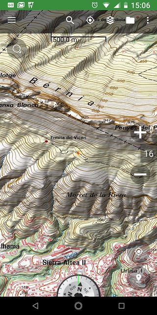 [/img]
For me, the valencian goverment has better maps that the IGN.
This web contains also air photos from the year 1956, and important information about natural protected spaces.
