
Hello all
If I were to follow this route...
[img] 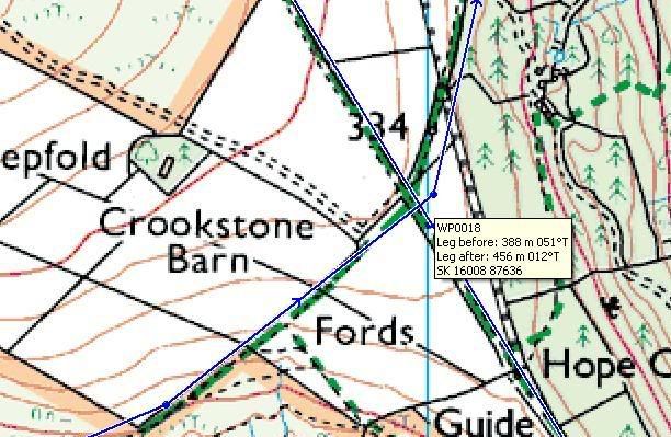 [/img]
...then is there a tolerance around WP18 at which my old Etrex would consider me to have 'arrived', i.e. begin directing me to the next waypoint?
Snippet of route nicked from [url= http://www.singletrackworld.com/forum/topic/another-peaks-route-reqeust ]this[/url] thread, btw.
Cheers
Look at the map.
There are four tracks at the junction. Given the angles the meet at, what's the chance you'll take wrong one? GPSRs are only so accurate anyway - as are the maps.
IIRC you can set the arrived tolerance on the unit. It will be a distance of between 5 and 100m or so.
Fair enough, druidh, in this specific case, but my GPS's won't start navigating to the next point until it knows you've been to this one.
This pic was to illustrate a point. When planning a route, a WP may end up on the other side of a (unmarked) fence, say i.e. inaccessible.
@Geoff - I'd have thought that, too. Can't find anything, though.
Ta anyway
What GPS, you can defo do it on some Garmins
ph0010421 - Member
Fair enough, druidh, in this specific case, but my GPS's won't start navigating to the next point until it knows you've been to this one.
This pic was to illustrate a point. When planning a route, a WP may end up on the other side of a (unmarked) fence, say i.e. inaccessible.
...and to think some folk on here mock the SatNav drivers who end up driving off piers etc....
Hi Geoff
Something like [url= http://www.ebuyer.com/product/177662 ]this one.[/url]
druidh - I'm struggling to simplify the problem enough so you can grasp it.
I use a Garmin etrex, and navigate via tracklogs, not routes. The etrex displays the route as a coloured line on the map (you can tweak the colour) and your position as a point with a circle which varys in diameter to show uncertainty (as fix signal varies).
You get to decide whether you are on track or not!
chrispalmr - Member
I use a Garmin etrex, and navigate via tracklogs, not routes. The etrex displays the route as a coloured line on the map (you can tweak the colour) and your position as a point with a circle which varys in diameter to show uncertainty (as fix signal varies).You get to decide whether you are on track or not!
Good idea. Mine is a simple LCD screen, but I'll give it a try.
Cheers
I'm not familiar with your unit but on my Garmin, I'd manually select 'Goto WP19' when I was at the junction of tracks, then go back to auto navigate after I'd reached WP19 - is that possible?
There's a technique in walking with a compass called "bearing off". This can be adapted when using a GPS by re-plotting WP18 to some small distance before the junction, then perhaps adding an additional, interim, waypoint some small distance after it.