
MegaSack DRAW - This year's winner is user - rgwb
We will be in touch
Just wondering on something for work - how easy was it to explain where you were to the 999 call handler? And how easy do you think it was for the MRT to find you?
Strangest question of the week award.
I can't see how mountain rescue would be needed, air ambulance maybe, which I saw on the Marin one day. Trail centres are surely too accessible to warrant the attention of mountain rescue..?
I carry a GPS at trail centres for emergency location, (though thankfully have never needed it yet). I was quite impressed with the numbered waymarkers at Whinlatter, presumably for the same pupose.
no but in the days prior to mobile phones the notices in red telephone boxes used to advise what services you could obtain when dialling 999 - i do recall some comedian noting that manchester picadilly railway station must be a popular point to call out for cave rescue from
more on topic if i ring local police non emergency to report (illegal) off road mx and quads then they will not take a grid reference
similar when i rang 999 for mountain rescue mid winter after coming off kinder in the snow and dark and listening to whistle blasts all the way back to the A57 and getting a signal - mountain rescue rang me back half an hour later for a specific location
<tannoy>TJ TO THE FORUM, TJ TO THE FORUM</tannoy>
Why is it strange? If you fall off your bike and need an ambulance, the chances are a road one won't be able to get to you. In North Wales you could well get the services of Squadron 22 (RAF Valley) rather than the air ambulance, which would involve police/mountain rescue to scramble the RAF helicopter.
I'm just thinking whether it would be useful for the call handlers to have a map of the trails with location of the numbered posts.
If you're at Llandegla then OPA staff escort the ambulance along the forest tracks to the closest point with their 4x4. But there wouldn't necessarily be anyone to show the ambulance crew how to get to you at another trail centre - hence the need for heli/MRT.
[url= http://www.dailypost.co.uk/news/north-wales-news/2009/01/12/prince-william-posted-to-raf-valley-55578-22670242/ ]..... and you could even get rescued by the future King!![/url]
Lou,
When Chunky Paul had a face to face with a Landy we had no problem vectoring the Helicopter in and some us when down the road at various junctions to guide the Ambulance crew in.
With regards the GeoLocation stuff grab me next time you see me I'll be happy to melt your mind/give you some ideas on the subject as I'm in that sorta trade, well Telecoms and emergency call handling from converged networks is always a hot topic.
Squadron 22 in action
[img] 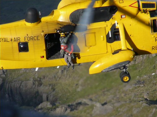 [/img]
Thanks Russ. Went to see Gwyn today, and it just got me thinking... and what with the cock up last year when she called the ambulance from Penycloddiau and eventually got Squad22.
I'm thinking that the MR liaison officer should be able to get locations from the FC, it's just whether it would be a worthwhile thing to do.
I always assumed emergency services would be well familiar with the local trail centres, they must be there most weekends.
Calling out the mrt???
Sheesh!
Everyone knows that you should self-evacuate....
😉
Have an app on my phone that'll spit out my location as lat/long and OS grid reference.
Squadron 22?
*Deploying Pedantry Ray*
That'll be 22 Squadron.
Oh well, at least it isn't the BBC banging on about the Royal 'Anglicans'.
Given the topic, I was wondering why you were being so specific about a trail centre. It almost doesn't matter whether it is a trail centre or not - OS maps will have the details needed. Unless you are putting a requirement upon the builders / operators of a trail centre then no difference to countryside. Are you then talking about the 999 call handlers, or someone else?
Numbers first - 22 Sqn (C Flight, RAF Valley) 🙂
I was just thinking if you're on natural stuff then you're more likely to have a map and be able to give an OS grid reference. Do you think there are many people that would have a map with them and know where they are when riding Penmachno (for example)? If you could phone the emergency services and say I'm near post 141 on Penmachno MTB trail, and the 999 call handler knew where that was - that would make finding you easier for everyone.
Some climbing locations are there already so you can phone and say "we were climbing on Idwal Slabs and my mate fell off" and the call handler will know where it is. MRT would know anyway, but if the call handler didn't know they wouldn't know which MRT to call.
I'm not really sure if the same applies to MTB so I don't know if its worth the effort.
Anything that would help a co-ordinated effort would be welcome I'd have thought. Years ago I was first on the scene at a climbing accident and called 999 after a long run to the nearest phone (pre-mobiles). It was painful to watch the regular ambulance crew going the long way across rough ground with a normal stretcher.
how easy was it to explain where you were to the 999 call handler?
Not really sure I understand your question! Is it more difficult to read a map in North Wales?
lou p - Member
Do you think there are many people that would have a map with them and know where they are when riding Penmachno (for example)?
No - but then I have incredibly low expectations of people doing the first thing to equip themselves for adventurous activities.
Trail centres breeding a lax approach to self-reliance so emergency services must work harder to compensate for individual shortcomings. Discuss.
Nothing to discuss, case proven m'lord. Mind you, even experienced folk might not bother with a map, seeing a trail centre as an easy no-brainer day when you don't want to think too hard?
I called an ambulance for a bloke with a broken hip on the Whinlatter Altura trail once - rode back to the trail head, phoned 999 and then directed the ambulance back to the bloke.
From the Ogwen MRT website:-
2 1 Jun 2010 19:45
to
20:35 Marin trail above Llanrwst A lady walking her dog in Gwydyr forest became disorientated. Although she followed several tracks and was actually on the signposted Marin trail she lacked the confidence to continue. She was told to stay at one of the marker posts whilst a Team member walked up to collect her.
May 2010 14:27
to
15:40 Marin Trail, Betws y Coed The casualty was one of a party of 7 MTB’ on the Marin trail who had fallen off and broken his collar bone, on Ride Fast Ride Free section. One of the group cycled down to the car park to get a phone signal and request help. As the casualty was only approx 100m from a forest road and walking towards it, the Team Leader on scene decided to call an ambulance rather than the team. The casualty was taken to hospital for treatment and discharged later that day. The group were well equipped and well experienced; it was just an unlucky fall. Mountain biking 1
To the OP, you do carry a whistle & torch don't you, so that if you've called MR via 999 with a vague location you can then use sound/light to attract their attention as they search for you in the wastes of the welsh forests?
TooTall - MemberTrail centres breeding a lax approach to self-reliance so emergency services must work harder to compensate for individual shortcomings. Discuss.
The maps for Afan include identified 'ambulance pick up points'.
Yep to whistle and torch, and space blanket and first aid kit. I've come to MTB from a hillwalking/climbing background so have some understanding of how to be prepared when out and about.
+1 for TooTall's comment. It's the same as seeing hillwalkers with jeans and trainers, no water/food or extra clothing going up the Pyg Track on Snowdon or Tourist path on Ben Nevis.
What you would always use and you should know how to use if you spend time in the mountains, map and compass and give the MRT a GRID REFERENCE, I know you are going to all say GPS these days, OK fine but they have batteries that go flat and then you are stuffed, so you should always have a compass and map as your back up