Your looking in the wrong places
As far as the Cheviots go i love it for the isolation,
prefer the Scottish side with a trip onto the summit and a visit to the WW2 aircraft crash sites (wellington and B17) on a summers day,
Its not techy-its xc, so its not Glentress.
But some nice long rolling descents, after long rolling climbs
Coastkid, couldn't agree more; whereabouts is that crash site? Do you have routes of those rides you've linked to in the videos? I think I've done very similar, but always interested in variation
Yep. It's heatherhope. I come back that way from derestreet, buchrig.
Last time I was at home I was trying to fine some techy sheep singletrack, problem was that it was too technical as sheep do not need to worry about wheels and the side of the hills are so steep.
[img] 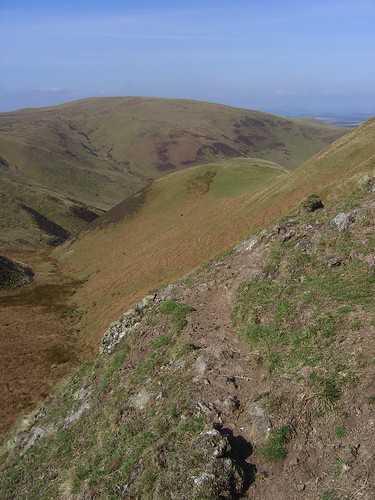 [/img]
[img] 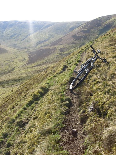 [/img]
I always look at the sides of the hills at the lovely looking tiny sheep trails and wonder if they could offer good riding.
[img] 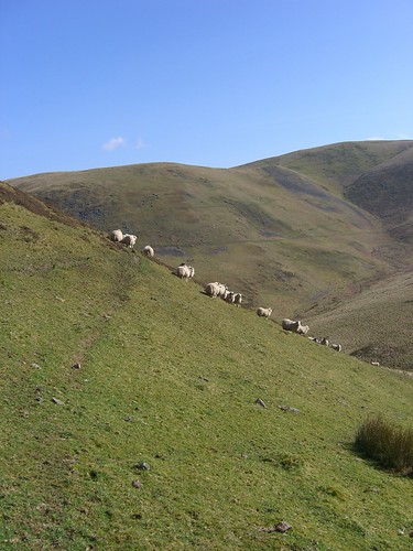 [/img]
Some xc helmet cam from the Cheviots here :-
http://www.pinkbike.com/video/141637/
http://www.pinkbike.com/video/138320/
http://www.pinkbike.com/video/150935/
http://www.pinkbike.com/video/148534/
All descents BTW * : P
Stranga
Is this Kidland, looks to steep for Thrunton?
[url] http://www.pinkbike.com/video/144703/ [/url]
bellerophon;
I dont have a GPS just good old maps and memorys 😮
The Wellington wreck is about 150 yards east of the junction on the Pennine Way where there is the path to the Cheviot summit,
The B17 is Near Hadons crags, ride North from mentioned junction then before the Way drops off the summit to the Gurkha Hut you will see the crags on your right (east), best stash the bike as some big heather hags to cross, go in really dry weather and you will see more as the wreakage rises out the dry peat,only needs about 2 weeks dry weather which does actually happen up there 😮
Heres links to the wrecks;
[url= http://www.aircrashsites-scotland.co.uk/boeing_b-17g_west-h.htm ]B17[/url]
And The wellington Wreck i read about now seems to be ID as a Vickers Warwick, 2 links;
[url= http://www.edwardboyle.com/wreck10.html ]Vickers Warwick Wreck[/url]
[url= http://www.aircrashsites-scotland.co.uk/warwick_the-cheviot.htm ]Vickers Warwick Wreck[/url]
Theres a de Havilland Mosquito wreck up there somewhere near the Curr to find this year too 😉
toons,
Its neither. And yes its steeper than Thrunton but maybe not quite as steep as Kidland or Kidlandlee.
Please close this thread, it's making me unhappy. 🙁
Know what you mean 🙁
[url= http://farm5.static.flickr.com/4130/5175251165_7f9b079f0a_b.jp g" target="_blank">
[url= http://www.flickr.com/photos/clarkpm4242/5175251165/ ]Alwin descent[/url] by [url= http://www.flickr.com/people/clarkpm4242/ ]clarkpm4242[/url], on Flickr
[url= http://farm5.static.flickr.com/4089/5175855630_d182837286_b.jp g" target="_blank">
[url= http://www.flickr.com/photos/clarkpm4242/5175855630/ ]Usway descent[/url] by [url= http://www.flickr.com/people/clarkpm4242/ ]clarkpm4242[/url], on Flickr
🙂
Stranga would you mind PM'ing me the location?
Aye it was good but we maybe bit off a bit more than we could chew riding in from Cocklawfoot and ahem having 2 pints and lunch at Alwinton! on one of the hottest days of the year!,
Yeah adding would make it pretty big. When I first came up with the route and rode it that was on the hottest day of the year mid 30s in some parts of the valleys. It was also a bit bigger and different to the published route due to access restrictions it had to altered. Took all bloody day to do as had to keep stopping to cool down.
Goes down of one my best days out on the bike though, red hot, good riding buddy friend, couple of novices and a pint after.
drac is this the killer loop that was in an old MBR?
[img]  [/img]
Small pic i know...
drac is this the killer loop that was in an old MBR?
If it isn't it'll be pretty close - Drac please confirm. I've still the old mags with the loops in it (I think two different mags did very similar routes) I'll dig em out, that pic also looks very much like the cocklawfoot to alwinton ride we do....
Iv'e got 2 cheviot MBR loops on pdf if anyome wants them - mail in profile.
This one:
[img]  [/img]
And this one:
[img]  [/img]
Thanks for the pdfs Carl.
🙂
drac is this the killer loop that was in an old MBR?
Not sure, fire the PDFs I have vague recollections of one but not bought MBR for year now. The one I remember was crap and it was clear they hadn't ridden much of the route as the description were miles off.
Cheers Carbon.
No that's not the same it's the one we sometimes do though for a Sunday pootle, the one I did for ST is bigger than that. It is similar to the one I did for MBUK iirc, was it MBUK I forget.
Not a bad route but not a killer really.
And for the record I've now deleted the PDFs as that would copyright theft as I don't have the original any more.
ir_bandito:
Where is Dipton Burn? Is it the one that runs through Dipton Mill? If so, could you tell me where that trail is please? email in profile if you don't want to reveal to the general populace or it is a bit cheeky!
Cheers,
P
The trail in the pic is fully fledged bridleway [url= http://www.streetmap.co.uk/map.srf?X=391504&Y=561328&A=Y&Z=115 ]here[/url]. Cracking Descent. Yes, near to the Dipton Mill.
The cheeky trail that runs east-west along the top of the woods to Nubbock for 3 miles is one of the best bits of flowy singletrack around here.
Much obliged. May venture over this weekend.
P
I'd offer to show you round, but I'm away this weekend. But I can point you in the direction of a few locals for guidance if you'd like. email in profile.
Northumberland is a nice place, but crap riding
Just keep thinking those thoughts, it will leave it clear for the rest of us who enjoy the place
coastkid
bellerophon;
I dont have a GPS just good old maps and memorys
Yep, Me too although beginning to think about a gps.
Thanks for the pointers to the sites.. let's hope for a dry spring\summer 😆
Cheers Bandito. I know the common well so was looking to expand a bit. Are the trails easy to explore around there and/or is there much else apart from that bit? I've got the whole of the w/e to play as the other half is working at home so I need to be out of the way so am happy to explore on my own.
Lucky situation to be in 🙂
Its quite easy to find that particular trail with an OS map. Problem is joing it with other trails to get a loop. You either need to ride up on the common, which unless there's a sudden sharp freeze, is going to be rubbish. Or use the network of trails nearer to Hexham, which may or may not be on a map, and may or may not be cheeky 😉
You could always get in touch with Hexham Bike Shop. They usually do a sunday morning ride, look on Farcebook.
Much obliged!
P
Wow what have i started, still non the wiser as to the whereabouts of the holy grail of Cheviot riding, perhaps i just can't see the wood for the trees, guess it's just a case of keep exploring, thanks for the reply's.
Thanks for starting ti Fergal. Given me the incentive to get up to the Cheviots again as soon as I can 🙂
P20 - Member
[i]Northumberland is a nice place, but crap riding[/i]Just keep thinking those thoughts, it will leave it clear for the rest of us who enjoy the place
Aye, well, I was going to type that it's the kind of place best left to those of us unfortunate enough to live there, but seems that even the above escaped most people's sarcasm radar, judging by the responses. Never mind.
Shackleton- I'd echo what bandito says about conditions atm. Anything on the moors is going to be utterly filthy for a while (unless there is a serious drop in temperatures). The usual stuff in dukes wood and elsewhere - I haven't been in of late- can be a bit mucky, but good for joining into the one linked to. With a weekend to explore you might even find some of the good bits.
Here we go dug out the two mags I have. This one is from
MOD: Image removed due to malware
and this one is from
MOD: Image removed due to malware
and here's a piccie (well just) of pennine shore:
MOD: Image removed due to malware
There does seem to be a theme with these ones I've posted... On the Total Bike route we don't do the bit from point 13 - 12, we go along the track by the reservoir and then turn up the hill for a very steep climb...
but seems that even the above escaped most people's sarcasm radar, judging by the responses. Never mind.
It often is as sarcasm doesn't work to well in written form.
here's a piccie (well just) of pennine shore:
Well named!, heres some more 😮
er is it legal to ride this being in Englandshire? 😳
[url= http://farm5.static.flickr.com/4004/4693488149_c27244332c_b.jp g" target="_blank">
 http://farm5.static.flickr.com/4004/4693488149_c27244332c_b.jp g"/> [/img][/url]
[url= http://www.flickr.com/photos/coastkid71/4693488149/ ]cheviots,cannon 036[/url] by [url= http://www.flickr.com/people/coastkid71/ ]coastkid71[/url], on Flickr
[url= http://farm5.static.flickr.com/4056/4693486345_7fbb0149e6_b.jp g" target="_blank">
 http://farm5.static.flickr.com/4056/4693486345_7fbb0149e6_b.jp g"/> [/img][/url]
[url= http://www.flickr.com/photos/coastkid71/4693486345/ ]cheviots,cannon 033[/url] by [url= http://www.flickr.com/people/coastkid71/ ]coastkid71[/url], on Flickr
[url= http://farm5.static.flickr.com/4071/4694126424_4e8aa39701_b.jp g" target="_blank">
 http://farm5.static.flickr.com/4071/4694126424_4e8aa39701_b.jp g"/> [/img][/url]
[url= http://www.flickr.com/photos/coastkid71/4694126424/ ]cheviots,cannon 034[/url] by [url= http://www.flickr.com/people/coastkid71/ ]coastkid71[/url], on Flickr
Sure its over a mile of this stuff from the trig point to the Border Gate 😮
[url= http://farm5.static.flickr.com/4059/4693514663_7f0aa29e97_b.jp g" target="_blank">
 http://farm5.static.flickr.com/4059/4693514663_7f0aa29e97_b.jp g"/> [/img][/url]
[url= http://www.flickr.com/photos/coastkid71/4693514663/ ]cheviots,cannon 051[/url] by [url= http://www.flickr.com/people/coastkid71/ ]coastkid71[/url], on Flickr
I keep getting drawn to this thread! Really enjoying the vids, pics and reading your different routes.
Have just been to my routes library and about 10 years ago I did the MBR route starting from Alwinton, Clennell Street, Hazely Law, the infamous Davidson's Linn, Salter's Road to Ewartly Shank, Hazeltonrig, Biddlestone.
25 miles solo on a very hot day and felt that I had the place to myself. 8)
er is it legal to ride this being in Englandshire?
Dunno, doubt it; I would say we've never had a problem with anyone when on them, but then I don't think we've met anyone when on them - if you get what I mean 😕
I have only met a few walkers up there and either they have been that knackerd or that pleased to see someone they didnt mention it 
Liking the Pennine shore. Similar to Dun Fell - Cross Fell.
Stranga, love the vids. Any chance of a location?
cinnamon_girl - Member
Please close this thread, it's making me unhappy
Don't be sad 🙁
cinnamon_girl - Member
I keep getting drawn to this thread! Really enjoying the vids, pics and reading your different routes.
That's more like it CG 😆
er is it legal to ride this being in Englandshire?
All but about 1 mile of which of course you go through the gate to Scotland and then back through the gate when it's legal. Yes that's what we do. 😆
Sorry toons unfortunately I cannot give you the location for that track (which is now even longer!) its not just the track thats secret but the hill/wood, hence why I did not post it on here with the others.
ir bandito if your local I can give you details on where to find a couple of those descents.
cheers.
i am local-ish (Hexham)
email to ir_bandito [at] yahoo [dot] co [dot] uk
I was planning a ride for the summer right around the Cheviots. Maybe as training for the Kielder 100. Anyway I needed some help planning the northern end of the route. I have a route in mind from Wooler to the Border Ridge at Clennel Street but was not sure where I would go from there. I was thinking to drop down to Cocklawfoot then cut over to the College Valley and over to Wooler somehow but would appreichate any advice. (Email in Profile if required)
Geda a good route would be down the collage valley then follow St Cuthbert's way from Hethpool up onto the Gallops, or if you want to stay completly off road follow the border ridge from the head of the collage valley to join st cuthbert's way down to hethpool, i have done both of these options.
ir I will email you.
GEDA, how about something like :-
Wooler
Broadstruther
Goldscleugh
Mounthooley
Red Cribs
The Schill
Cocklawfoot
Hexpathgate
Davidsons Linn
High Bleakhope
Low Bleakhope
Linhope
The Dodd
Calder
Wooler
Oooh, I missed this a bit
I'd offer to show you round, but I'm away this weekend. But I can point you in the direction of a few locals for guidance if you'd like. email in profile.
I'm riding from the 'ham on Saturday. Foxy's looking to buy in Hexham so I'm going to show him around a little bit and get a ride in before the rugby. I'd be happy to show someone round then if it suits if you put them in touch with me.
The Dipton singletrack will be [b]very [/b]wet though. It won't be nearly as much fun as it should be and it'll cause a lot of damage. We're probably going to ride the 3 peaks route.
