I had assumed you'd have it covered already Ian 😉
Unlike the area around A1, A4, A5 and A11, and that's before I consider A3 and B4. Still scratching my head on these.
Local knowledge must be great for doing this event.. Driving down from Fife, Scotland with my mate to do this. Still to sit down and look over the maps and try to put it all together.. Might be back soon for some much needed advice 8O!! Really looking forward to it having never attempted anything like it before...
Even though I'm only a couple of hours away at most I don't know the area very well, sit down with a map and with Google Earth and it's fairly easy to plan a route, ask a few questions about bits that look a bit interesting and away you go.
I've not got a route that takes in all the sights, all the WPs, has a pub at 35 miles on Saturday and Sunday and is 113 miles long and 21000ft of climbing, just need to check out a couple of bits and it's looking pretty good really.
Ok, think I have it now. 161 km (100 miles) and 5400m ascent with all the check points.
I think the aspiration to be west of Cader by Saturday evening is very much weather dependent. If my experience of riding a loaded bike in the Beacons is anything to go by, then B1 is going to take longer than it looks.
has a pub at 35 miles on Saturday and Sunday
This is what I like to hear 😀 I guess your planning not to move from there 😉
Depends on how good the pub is (last year's pub was great), but I should point out that the pubs are at 35 miles and 70 miles respectively, so if we can make it to the first one on Saturday, the second should be 'easy' on the Sunday, given we'll have more time to get to it 🙂
Stu - cheers for that link - I had been on satellite images and had a similar climb up to the ridge line (not easy to make that work through the maze of forest tracks) but wasn't too sure how far along the ridge to go before dropping off north.... All the way basically!
Looks like a great descent - let's hope it's not into a westerly gale!
All change for us.
Everybody's talking about clockwise routes. Looks like the woods near Dolgellau will be full of bikers in bivvy bags on Saturday night.
CBA with a big pack ride to Machynlleth on Saturday afternoon, so were going to do our route backwards, anticlockwise, to get away from the crowds.
The route to B4 and on to A3 looks great going the other way. Then it'll be a full roast for sunday lunch at Dolgellau whilst you're all in the middle of nowhere eating cous cous. Ace. 😀
The best bit of all is that Monday morning will be [i]insanely tough[/i]. Yay!
My route will be planned around a pint & some lunch in the Railway at Abergynolwyn, that is all.
Is this going to be the real ale wobble with bivi thrown in???
Is this going to be the real ale wobble with bivi thrown in???
And without having to queue in a dogshit strewen flooded rugby pitch for the 2 toilets, one of which is overflowing....
After some playing around and deliberations I think I have a plan now... likely to be 13 check points that take in 136km and 5040m of climbing around sunny* North Wales. As IanB says B1 might take a bit longer and we might even use that as our first night out if the weather is good - should be some good views of the sunset over the Irish Sea and a good down hill to get going on Sunday a.m.
Working on the short cuts and bale out options if weather and conditions dictate.... roll on the next May Bank Holiday!
* Stu - you have arranged this haven't you?
It would seem we're having the rain now, rather than the end of May 😉
But what tyres should I take? 😯
If it were me, I'd sacrifice a bit of grip for a fast rolling, lightish tyre ... swampthings possibly not the best option 😀
I've been on Furious Freds for weeks 😀 I'm actually thinking Racing Ralphs with a Nobby Nic maybe on front if the rain comes.
yes fast rolling tyres for me I need all the help to roll my rig on this epic 😀
Steve and I had a good planning night on Friday, added in some sweet looking descents for good measure. 😯
Going to sort out saddle bag later as my home made dry bag effort probably wont survive a 2 day mission - or would it 😉
My Maxxis Avantage/Ardent pair are starting to resemble slicks. Does this count as 'fast rolling tyres' 😉
200!
Losers 😀
Page 6
I do believe that is a hat-trick 😀
I switched from my Ardents to my Race Kings the other day. Huge difference in rolling resistance, and most likely grip, but I'm sure they'll be fine.
congratulations to you page/post hunters 😉
With a heavy heart I 1x9'd my slot-dropout Inbred the other night, in anticipation of some loaded welsh climbs.
28lb without luggage. 😥
I am sure Stu will be along to say it's character building 😆
I haven't weighed my 456 but I know it's got to do 😉
Sorted out a rough plan for a route at the weekend, now to spend this week doing a bit more investigation and 'google earthing' to fine tune it. Not being local, we had a couple of questions that hopefully someone can answer for us please!
- are there any free water taps anywhere in Machynlleth or Dolgellau where we can fill up?
- we're assuming that the forest tracks going directly west from the start are fair game. Is that right?
I'm sure Stu will let you fill up with water before you leave the start, plus plenty of streams etc to get all you need 😉
Forest tracks directly west of the start are fair game but keep to the north of the valley bottom as they're felling at present on the south side ... Forest Freeride soon to be Deforested Freeride 😉
Like Pete says, you shouldn't have trouble finding water wherever you are. Be sensible about where you collect it and you won't die*
*I take no responsibility for any deaths.
Forest Freeride soon to be Deforested Freeride
😆 No comment...
[IMG] 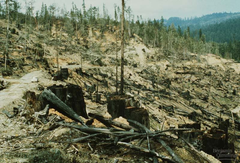 [/IMG]
😯
To be fair, it does look a bit better than that!
Yes, it's a tidy job and in the long run it'll give me more things to ride 😀
phew that's good to hear.
Perhaps some North shore sections over the stumps Stu?
Plenty of Shore type stuff in the fields already Pete 😉
may have a play before/after WRT then 😉
I've a nice gap jump with your name on 😯
Loaded or unloaded?
Is it re-enforced with girders?
Can I have a go? 😉
All welcome but come up short and it'll happily remove your teeth 😀
Good to hear that the tracks to the west are fair game - I was going to ask the same question!
Sorry to hear of your loss of tree cover Stu - is the sunlight a bit frightening 😕
Thanks for the replies - looking forward to this weekend, particularly having only walked around parts of this area before. We seem to have plotted a route with around 5600m of climbing, which could be, hmm, interesting.
You'll climb nearly that just to get out of the forest 😉
Excellent - so after that it'll all be flat then. 😉
Having lost my routes due to a software glitch, the new route is 114km with 4700m up.
If weather is good the gear is weighing in circa 4kg complete with tent & food 😀 The Lomo bags recommended on here, the 12l can easily hold a tent, sleeping bag and mat.
Is the campsite at Cringoed any good, need somewhere to sleep on Friday night and potentially Monday night?
Campsite at Cringoed is fine, although they only have limited camping pitches.
I've just ordered some mosquito net so I can [get Beth to] retro-fit something to my Hunka to give me some protection from midges once under the shelter of my tarp.
What are other people doing about avoid the winged teeth, particularly the tarpists?
