Coolhandluke - that's the international trackstand stadium 🙂 . my commute to work had one section that I wished had a cycle lane, as it would save me going around the one-way system. the council have just recently dug up the road and put in a cycle lane!... I should really have saved that wish for something better..
[i]sc-xc: that makes perfect sense to me. It's not a "lane", it's a restriction that prevents cars parking or queuing/entering the road directly in front of that dropped kerb[/i]
Well, yeah, perfect sense... IF YOU KNOW! How do you know that?
Well, yeah, perfect sense... IF YOU KNOW! How do you know that?
https://www.gov.uk/browse/driving/highway-code 😀
Specifically Rule 140: [i]"Cycle lanes. These are shown by road markings and signs. You MUST NOT drive or park in a cycle lane marked by a solid white line during its times of operation. "[/i]
[img] 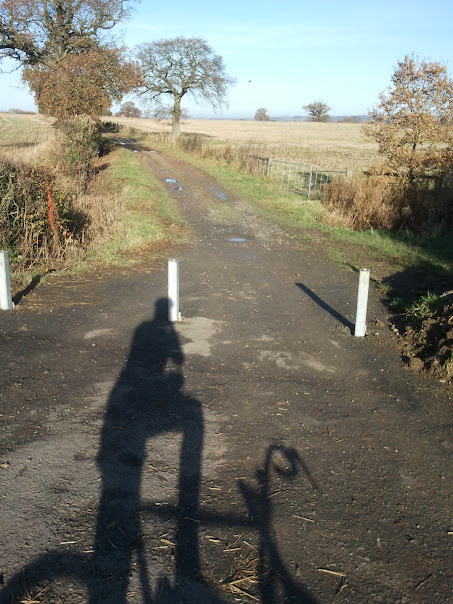 [/img]
this in NCN41, and what you can't see is round the corner the surface is slate chippings, other sections in the are packed dirt farm tracks. Considering this is a rural path and would form a perfect alternative to the A46 the crap surface is almost inexcusable.
slight aside, i believe that UK houses are the smallest in Europe, how does this affect the storage of bicycles? how is it managed elsewhere in Denmark, Netherlands etc.
I had an argument with Slough Council on Twitter the other week.
Someone tweeted them and asked what the rule was on cyclists not using cycle lanes, and the Council Twitterer sounded all suprised that people would "tangle with the traffic when we've provided a nice cycle lane"
Here's an example of some of Slough's primary east-to-west cycle lanes.
[img]  [/img]
Can you spot them? Yep, all they've done is legalised pavement cycling on a completely unsuitable bit of pavement, and called it cycle provision. The road, by the way, is an unimportant one called the A4
What usually happens is that the council suddenly realises they're supposed to spend 0.1% on cycling infrastructure, so in a panic they slap some green paint and some signs down before the end of the financial year.The purpose is not to provide cycle facilities, the purpose is to ensure continuity of council funding for next year.
Correct
i believe that UK houses are the smallest in Europe, how does this affect the storage of bicycles? how is it managed elsewhere in Denmark, Netherlands etc.
Good question, unfortunately I think this is mainly due to crap design and builder obsession with crap barret home style small detached-for-the-sake-of-it sprawling estates rather than better quality semis and terraced house.
The consequence however does mean it can be easier to walk and and jump in a car than grab a bike from a convenient storage spot near the door. When I was using a bike a for my main mode of transport I had two commuter esq bikes as well as my fun mtb and BMX so storage was a challenge.
True that the UK doesn't exactly design for bikes. But doesn't your classic Barrat house have a rather convenient garage to store bikes, that is even accessible directly from the house?
[img]  [/img]
grahams, your going to big, most houses lack the garage. or at least on the estates near me.
[url= http://bloorhomes.com/developments/cheltenham-green/ ]http://bloorhomes.com/developments/cheltenham-green/[/url]
[url= http://www.bromfordhomes.co.uk/find-a-home/st-pauls-walk/overview/ ]http://www.bromfordhomes.co.uk/find-a-home/st-pauls-walk/overview/[url=http://][/url]
a few other sites do exist and all follow the above two models, one open market one social.
Although this
[url= http://www.nashpartnership.com/projects/index/view/cPath/9/projectsID/62 ]http://www.nashpartnership.com/projects/index/view/cPath/9/projectsID/62[/url]
is odd because they make a point of stating cycle storage, what form i haven't a clue.
Probably a crappy "bike shed" with a door that can be easily lifted off its hinges by any budding criminal. 😕
Considering this is a rural path and would form a perfect alternative to the A46 the crap surface is almost inexcusable.
Because it's been designated by a charity as a leisure route, rather than a transport route, and it's a work in progress.
http://www.sustrans.org.uk/what-we-do/national-cycle-network/route-numbering-system/route-41
Sustrans get a lot of stick for the quality of their routes but they do tend to go back and upgrade them over time when funds allow.
Mr Agreeable i tend to agree, just wish they hadn't bothered putting up any signs to be honest, it may be a work in progress but it is fully signposted. it is a bridleway it is usable as such but as a cycle path it isn't really much use. With a name NCN i would like to see it being a transport route, and it would be almost perfect as an alternative to playing on the trunk road with blind drivers, reps, etc.
believe that UK houses are the smallest in Europe, how does this affect the storage of bicycles? how is it managed elsewhere in Denmark, Netherlands etc.
New homes in the Netherlands are legally obliged to have an area for cycle storage.
http://www.aviewfromthecyclepath.com/2008/09/cycle-parking-at-home.html
The moral seems to be that if you want people to cycle in serious numbers you have to encourage it.
MrMo, I'm pretty sure I've ridden that route (along with a bunch of Sustrans staff) a couple of years ago. It wasn't great but it wasn't impassable either.
I think the days of signing an old railway or a farm track as NCN and expecting cyclists to take it as they find it are largely in the past, but it did enable Sustrans to create and advertise a massive network of quiet or traffic-free routes in its early years, on a budget that wouldn't pay for more than a mile of new motorway.
If you've got 10 minutes there's an audioslide I put together of John Grimshaw talking about the birth of Sustrans.
By his own admission they were more or less winging it (I particularly like the bit about him applying for £42 million funding because of Hitchhikers Guide to the Galaxy), but they achieved an incredible amount, and I think they're partly responsible for the massive rise in profile of "normal" cycling over the past few years.
I'm pretty sure I've ridden that route (along with a bunch of Sustrans staff) a couple of years ago. It wasn't great but it wasn't impassable either.
It is Elmley castle to Ashton under hill, yes it is rideable but, the surface is what appears to be slate chippings, which when your riding 16miles to and fron work isn't the best surface, not a lot of grip, slidey and a high risk of punctures.
As an example of something that's been created for tuppence ha'penny and is broadly aimed at more experienced riders who want to go on a jolly adventure, the NCN is pretty good. As a substitute for roads that gets you from A to B efficiently, it's generally pretty poor. Can't we have both?
Can't we have both?
of course, just feel that in that place, it would be nice to have a route that as a cyclist didn't involve a major trunk road carrying HGV's etc to the M5 at tewkesbury. There is a reasonable cycle path to Hinton and the road from the Teddington hands going south isn't too bad, just the bit from hinton to Teddington. Thing is from hinton there is a dirt road, which says no cycling that takes you to Ashton under hill, then a road that goes to Beckford and a final dirt road to Teddington. The NCN bit isn't as good as the track i shouldn't be using.
<small>View Larger Map</small>
....and money = a real problem for politiciansYou just need to be willing to take space away from cars.
hopefully if link works here's some excellent work in sheffield this pavement is a two way shared cycle lane now
less than 1.5m wide shared (pavement) bike lane near a college with a lot of foot traffic - adjacent to this the road has just been widened to 4 lanes to allow peak time right turns to queue back from next junction in a place 20m further up the road
and the rest of the route is crap as well had one parent at school verbally attack as had seen me riding on the road - "delaying my journey to work - when you can use the cycle path"
[url= http://maps.google.com/maps?q=st+joh n's+church+sheffield&layer=c&z=17&iwloc=A&sll=53.405202,-1.495903&cid=9044734430509818618&cbp=13,86.0,0,0,0&cbll=53.405194,-1.496094&hl=en&ved=0CA0Q2wU&sa=X&ei=2VatUPyNL-_GmQXj2oCQDA]Owlerton Green Sheffield[/url]
edit no idea why link won't post - copy and paste works - if anyone wants to tell me how to fix i'd like to know
[url= http://maps.google.com/maps?q=st+joh n's+church+sheffield&hl=en&ll=53.405195,-1.496095&spn=0.000013,0.009978&sll=53.405202,-1.495903&layer=c&cid=9044734430509818618&cbp=13,77.25,,0,5.84&cbll=53.405195,-1.496095&hq=st+john's+church+sheffield&t=h&z=17&panoid=qBkubXqXvaWGFmL_6bGtww[/url]
You might want to casually point out that you're not the one taking up six times the necessary amount of space on the road.
[img] 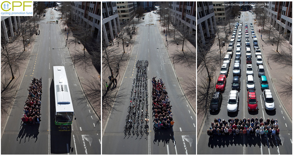 [/img]
(I bet they don't car-share. People like that never do.)
and how much room do those cars really need, allowing for stopping distances, where are the other cars parked on both sides of the road taking space....
it is a bridleway it is usable as such but as a cycle path it isn't really much use. With a name NCN i would like to see it being a transport route, and it would be almost perfect as an alternative to playing on the trunk road with blind drivers, reps, etc.
Yeah I agree that one thing that Sustrans aren't very good at is giving you some idea of the route quality (i.e. width and surface). They vary enormously from the mrmo's NCN41 dirt track to the wide smooth tarmac of my NCN72.
I think their basic requirement is that it should [i]at least[/i] be navigable by a sturdy touring bike.
I guess they have to work with what they can in the area. In some cases this means grabbing a route, mapping/signing it, then securing funds to improve it as they can. Perhaps the theory is that once a route is mapped then people will start using it and they can demonstrate demand to the council to get the additional funds?
Despite this niggle I think Sustrans have done an absolutely enormous amount for cycling in this country and seem to be one of the few cycling advocacy groups that are actually making a difference on the ground - so I'm proud to be a supporter.
http://www.sustrans.org.uk/support-sustrans/become-a-supporter
