This might be common knowledge, but in case it isn't:
Somerset and North Somerset County Councils are considering an application to upgrade Winscombe Drove to bridleway status. This lane is the "missing link" between Lillypool/Rowberrow and the Crook Peak area. The spur connecting to Sidcot is also under consideration.
There is likely to be opposition, and support and evidence of use from local mtb-ers (and horseriders) will be particularly valuable because the application was originally made in 1991 so many of the original supporters will no longer be around to back it. (It's been stalled pending another application which was finally resolved last year.)
The footpath reference numbers are AX 29/37 and AX 29/33. The relevant contacts are Penny Bale at Somerset County Council and Elaine Bowman at North Somerset (the lane overlaps into both areas) and a public meeting is planned for the 18th January (local venue to be confirmed).
Chris is that the lane opposite the road turning for Charterhouse just down from Lilypool ?
Yes, almost directly opposite Lillypool cafe. See [url= http://www.streetmap.co.uk/idld.srf?x=343921&y=156655&z=120&sv=343921,156655 ]here[/url] for a map (the arrow is pointing at it).
Well i may have on the odd occasion rode a bicycle along there !Ahem....
Better tell the nice lady from the council then! 🙂
Any indication at all that it's a Cross Road (see recent Singletrack print article)? That would be a clincher.
Given that what essentially looks like the same track leading from its eastern end is a metalled road, I'd be surprised if it wasn't actually an ancient right of way which has been severely mis-classified.
Wasn't this kicked out last year?
I'm not fully 'Au Fait' with the politics and legalese but as Chris says, this really is the missing link for cycle and equine traffic so much so I regularly use it irrespective of its current classification.
There are some pretty unpleasant people down there too mind. They're very anti-use rather than anti any one group in particular.
I'm going to have a look on the North Somerset website - see if there are any contact details. If so, I'll post them up.
I think Doctor Rad is spot on mind.
There was apparently a related application for Barton Drove (north side of Wavering Down) which was finally rejected last year after a very (!) protracted process, and the Cross Trails Trust have tried to persuade the various landowners to dedicate Callow Drove as a permissive bridleway, but that also ran aground.
I'm not really familiar with the full backstory on the Winscombe Drove application (we only found out last week) but you'd think it was a pretty clear candidate for upgrading. However the Somerset RoW office did seem slightly surprised to hear support for it, so the more people who get in touch with them the better.
Ah, yes, Barton Drove.
One of my friends parents live along there. His dads up for a fight about that purely on principle.
Its a shame Callow Drove ran aground too - I hadn't head about that one at all.
Did you phone in to speak to the ROW people?
Yes, Dave spoke to the Somerset office today.
Contact details for North Somerset are:
streetsandopenspaces@n-somerset.gov.uk
01934 888802
and for Somerset CC:
rightsofway@somerset.gov.uk
01823 356241
Those are publically-available details from the council websites - we also have more direct contacts for the case officers which I won't post here but I'll pass on if anyone PM's (email in my profile).
Response from Somerset ROW office ...
"We have over twenty horse riders who came forward at the time the application was made to say that they have used the footpaths as a bridleway however because this application is quite old many of these people have either moved away from the area or passed away.
We have arranged a venue for people to come to on the 18th January 2010 in the Winscombe area if they have used the footpaths at all, so that we can speak to everyone at once. If you can come along please let me know. If there is anyone else who would be willing to come forward about their use please encourage them to speak to me or turn up on the day. I am not 100% sure what venue my colleague has found in the Winscombe area but I can find out for you if you are considering coming.
As you may know unless we get people coming forward with evidence of use then it makes it very difficult to recommend making an order to upgrade the footpaths. The more people we have coming forward to say they have used the ways in a particular way the more chance there is of an order upgrading the footpaths being made so please encourage the other members of the group to either come along or speak to my colleague or myself"
Dave
I'll be there, used the Drove for years, caught a few times but never been put off!!!
As people have said Winscombe Drove really is the missing link on the mendips.
Growing up we used to do a lot of training for the Ten Tors of Dartmoor on the Mendips and always used the path, I could always remember horse crap and hoove prints on it and I sure we must of met horses.
When I got into mountain biking we used to use it to do a big old loop. We did this with no problem for a few years, then one day this middle aged women in a green volvo skidded in front of us dukes of hazard style and told us it was a footpath. She was not happy when we pointed out she was in a volvo.
The next few time we used it sure enough she stopped us again. We then checked out a new map and sure enough it was a footpath, so we stopped using it, I'm sure it was a briddle way on the old maps.
We did not used it for a while, but one day we were at Arts cafe and noticed someone had put a locked gate across the drove road, we decided just out of principle to climb it and ride along it. Sure enough Volvo lady turns up and gave us a mouthfull, so we told her we would carry our bikes as it was a footpath. My mate Si complained about the locked gate to the ROW officer and it was removed soon after.
Not used it for years, but i really can't see the problem. I know the stone based 1st part is used for access to some houses, but route everyone wants to use branches off as a dirt track well away from the houses.
gus
I have had a few run in's with that crazy old lady skidding out of control towards us' She really was quite lucky she never killed one of us one day when she was out of control and nearly slid into us which would have pushed us out onto the main road when there was lots of traffic
Loads of people in the cafe just couldn't believe it.
Has anyone made contact with the Horsey brigade?
"They're very anti-use"
Yep, they don't like walkers either despite it being part of the West Mendip Way. And there is a sign for no cycling at the Lillypool end.
Always ignored the sign it and ridden it to access Winscombe Down. It gets boggy at one point.
[img] 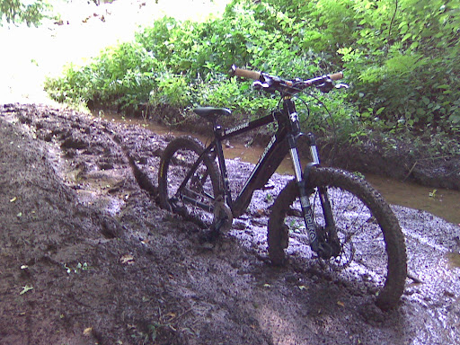 [/img]
I pinged rightsofway@somerset.gov.uk with my support
Bad line choice there Buzz 😉
Its a [i]line[/i]?
😆
Well I sent this:
I recently heard that there is an application to upgrade Winscombe Drove, on the Mendip, to bridleway status. I think this would be a very useful upgrade. I have occasionally used the drove over a number years as a safe route for off-road cycling between the Shipham/Rowberrow area and Winscombe Down - there not being any reasonable alternatives without diverting some miles north or south. Nevertheless, I've used the drove cautiously because I'm aware that it presently only has footpath status. An upgrade to bridleway status would be very welcome.
And got this:
Many thanks for getting in touch with me regarding this application.
Would you be interested in coming along to the Winscombe Community Centre on the 26th January 2010? My colleague Mrs Bowman and I will be there to talk to anyone who has used Winscombe Drove and will use any information we collect to assess whether an order to upgrade Winscombe Drove is warranted. The more people who come forward with evidence of use the more chance that a legal order will be made along the route upgrading it.Please let me know whether you can make it. I look forward to hearing from you.
Mrs Penny Bale
Rights of Way - Definitive Map Team
Environmental Management
Somerset County Council
Direct Line 01823 356188
Who else is going?
I've received the very same email.
Since this public meeting in 2010 is driven by the application originally submitted in 1991 😯 nearly 20 years ago, I'd say its pretty important that as many as possible represent. We may not get another opportunity in our lifetimes.
I'm definitely going
Me Too - Forgot to actually say that in my last post. 😆
Ok, I've just spoken to Elaine Bowman, Senior ROW modifications officer.
They're taking appointments to see people during the day. Since I'm filthy unemployed scum, I can make one of these, but how are the rest of you fixed?
I don't know what provision they're making for people who are gainfully employed, but they are sending out 'historic user' forms. Perhaps those of you that can't make it can fill these in and send them back?
Anyway, lets not let this fade away due to a little inconvenience.
I've made an appointment to see her at 9.00am on the 26th January.
Dave
So, I've just returned from speaking to the North Somerset, and Somerset Rights of Way Officers - giving them my evidence of use since 2000.
They were quite nice. I took the time to quiz them in regard of what gives weight to the changing of status:
Its exclusively its historic use and is evidence derived. Therefore its very important that if you have used it, you say so in a reportable (i.e. Written) format.
At the moment the feeling is there's not quite enough evidence to change it to Bridleway status. I pointed out that this may be because people work and couldn't get out to see them in Winscombe Community Centre.
We run a very real risk of falling at the first hurdle with this.
You can tell them this by post:
Contact Elaine Bowman at North Somerset Council - (01934 427406). She can send you a 'Public Rights of Way User Evidence Form' that you can fill in and send to her.
I'm told that you need to do this as soon as humanly possible for the ROW Committee hearing in March.
emailed. Sorry I wasn't free to attend.
Been down there today and they seemed very nice. As ScienceOfficer says, it would be a great shame to let this fail at the first hurdle. The track is not owned by any of the people objecting, so its just a matter of getting enough evidence of use. There isn't much to filling out the form either ...
If you want a form I have an electronic copy, email in profile.
Dave
Hey guys, I'm a member of the Woodspring Bridleways Association, we try to make sure that we publicise any Inquiries that are coming up and how we are getting on with them .. you can always try checking out our website 'www.woodspringbridlewaysassociation.co.uk'.
I try and keep it as up to date as possible, or always feel welcome to contact me ..
We worked on Winscombe Drove with Elaine...
Obviously anything that is is a Bridle Way, is also open to you guys as well ;0) So it makes sense to work together .. there are a couple of footpaths that are in discussion at the moment around Barrow Gurney and I want them to be looked at for Multi Access so that we can all use them rather than just the walkers, and may be looking for some support from other users ...
🙂
Julie Grove
Hi Julie,
Thanks for posting up.
There's alot of traffic on this site - you may have seen the last post prior to yours was 4months ago. If you can post up some details of the Barrow Gurney stuff, I can start a new thread if you like.
Its easy enough to do it yourself since you've just registered to post, but I'm happy to help out where I can.
What news on Winscombe Drove? I've not heard anything since I attended at Winscombe to give my evidence.
I live in Long Ashton, a stone's thrown from Barrow Gurney, so would be very interested to hear which FPs you're looking at ... (I may already, ahem, 'use' them ...)
;0) They are talking about putting one in somewhere down by the old hospital (Wild Country Lane?) and one in between Naish Lane and Hobbs Lane (just off the A38), there is also some talk of a footpath around the resevoirs somewhere .. I'm in the process of chasing up the council (NS) about these ...
I must admit there are a lot of potential 'FP's that I tend to use whilst walking the dog around BG, but I'm not sure how official some of these are! 😛
I'll chase up Winscombe Drove and see if there is any update ..Also, when I get more info re: BG, I'll start a new post, thanks for your help guys!
Sounds good.
A link between Naish and Hobbs would be great, especially if it also linked the end of Naish to the BWs on Barrow Hill.
If the 'old hospital' one upgraded the FP to the east from Barrow Common North up onto the old research station land, that would be awesome.
This is the reply I got a couple of weeks ago when I mailed Somerset ROW ..
A decision is still pending. I have completed my investigative report however I am waiting from my counterpart (Elaine) to catch up before we take it any further. Hopefully it won't be too much longer before it goes to our respective County Council committees.
Would you like me to notify you when this gets to that stage in Somerset? The meeting is a public one and you might want to come along.
Let me know.
Kind Regards
Mrs Penny Bale
Rights of Way - Definitive Map Team
Environmental Management
Somerset County Council
Direct Line 01823 356188
+1 for Barrow Gurney FP's! I live up by the Airport and ride up round Dundry/Brockley Coombe/Bourton Coombe etc. The more legal stuff to ride the better!
Thanks Dave.
I really hope this works out, I've never ridden that track because of what I've heard about the residents.
Really though, this sort of issue and thread could only happen in England. I'll happily drive at 85mph on a motorway, but my mainly English sense of guilt always stops me riding on local footpaths.
Good luck to everyone involved.
I've been riding that drove for years. It's ideal for upgrade and objections are just bloodymindedness IMO.
Thanks for the update all, I was in contact with Elaine yesterday and have the following information from North Somerset re: Winscombe Drove:
01/07/2010)- North Somerset is in the process of preparing their report and expect it to be put before the committee in November. Apparently the committee only meets 3 times a year and therefore this is the next suitable opportunity for the report to be presented.
I've also posted this onto the Woodspring Bridleways Forum (www.woodspringbridlewaysassociation/forum), and will try and ensure that information about Rights of Way etc.. are updated as soon as I have anything. The forum has just been setup, so bear with me as I try to get the info into it and feel free to join and make any posts if you have any info!
Thanks for all your help on this one... Re: Barrow Gurney - there seems to be a disconnect between the Parish and NS Council, so I need to go to the Parish meeting to get more info. Will start a new post once I have anything. J
Anyone know what happened with this please?
This is looking positive:
Look at all that map evidence...!
Thanks for the homework. Good to know the council has decided its worth giving it a try.
I've been told by both ROW officers (including Elaine - the Author) that its a virtual certainty that the recommendation will be appealed.
This is just the beginning.
I've been exploring Crook Peak and the surrounding area on foot with the dog the last two days and searching for info about it. Never knew there was such amazing scenery so close by.
Its a foot path and should be fully respected as such. Its this kind of illegal riding that gives us all a bad name. If I was the landowner I'd shoot you all on sight and feed you to the big Alsation dog that lives at the end of the land.
The interesting thing to come out of the Winscombe Drove case is that the landowners tried to close the stable door after the horse had bolted, as 'twere. They only put up notices etc in the 90s, AFTER the initial application had been made to upgrade to a bridleway. Before then, it seems, they weren't really making much of an effort to stop people using it on horseback.
This is hardly the beginning - that was 20 years ago when the initial application went in...! Very much hope this one succeeds, it will provide a great new link across the central section of the Mendips.
This is hardly the beginning - that was 20 years ago when the initial application went in...!
Yes, I know. But nothing happened with it because they were processing previous applications. Thats right - a 20 year waiting list.
Perhaps you mis-understand me. This is only the start of the legal process. My children could well be adults by the time its finished, although, if it goes to the secretary of state, it could actually be determined pretty quickly if the other one (Barton drove?) is anything to go by.
As of the 7th April, Somerset County Council have made an order to upgrade the definitive map to show their section of the drove road as bridleway.
The order will be published in the local press and a period of 42 days allowed for objections ....
Cheers
Dave
Rock!
a period of 42 days allowed for objections ....
Redsox alert!
Nice one Dave.
I was going to get round to this later today, but you beat me to it.
😆
When you say "their section" does this mean only part of the drove could be upgraded?
Had my first run in with the loony woman who partrols it earlier this month, wouldnt put me off riding it again, but I could do without that sort of confrontation on my bike.
agent, the drove is split between North Somerset and Somerset.
She's a delight isn't she.
Slightly different subject Scienceofficer,
There is a footpath running through Winterhead which I believe went through SCC on the same day for some sort of decision (upgrade?). Do you know anything about that?
Cheers
Dave
I know the one you mean.
It was mentioned in general conversation when I went for my evidence interview, but no, I've not heard nothing about that one.