I'm finding it hard to get sufficient climbing in as training for the Manx 100.
I'm based in South Chilterns - hard to get more than 1500m without doing hill repeats as the hills are short and sharp. 110miles of ridgeway gives the distance but is a quarter of the elevation 😥
SDW - the train/travel admin is a killer. Either a half day on Friday and B&B or a late start on the Saturday after most of the wee hours on the train followed by a night time drive.
Surrey Hills - no knowledge and no garmin maps. Gee's route would be great but I'd likely spend most of my time lost - anyone with knowledge planning a 12hr attempt soon? 😀
I'm starting to think that the easiest thing is a 50mile out and back on the SDW. I can do an early start and not shell out for trains/b&bs. Winchester is closer for me but the big hills are Eastbourne?
Any other suggestions gratefuly received.
Local road route with some nasty hills in it:
[url= http://www.maidenheadcc.org.uk/torture40 ]Torture 40[/url]
Repeat if necessary for the distance.
North Downs Way/Surrey Hills from Woldingham (near Croydon) to Newlands Corner and back. Lots of potential to loop around Box Hill, Ranmore and Leith Hill etc. The Lungbuster route on here is a good ride
http://singletrackworld.com/trailguide/uk/south-east/the-north-downs/
Living in Eastbourne and having ridden the sdw twice, out and back from Eastbourne to Amberley will be easier to organise and harder than 'just' riding the whole thing, and a good deal harder than out and back from Winchester.
Also less faff with wind direction with an out and back.
ETA Or Amberley - Eastbourne - Amberley might be even betterer for logistics.
Did Amberley to Eastbourne and return yesterday.
Ouch, they don't make hills like that in South Oxfordshire. 11.07hrs or 10.36hrs moving for 101miles and 3,780m ascent. Wet on way out, baked on way back.
Definately fitted the bill for easy to navigate with lots of hills 🙂
Amberley-Eastbourne out and back, or vice versa... or make a weekend of it and do Winchester to Truleigh Hill YHA (60 odd miles), and then Truleigh to Eastbourne (about 35 miles but lots of hills).
I'm also considering a double half sdw. Did you navigate only by finger post signs?
There's a lot of up and down in the Surrey Hills, if we're talking off road, though you're still just looking at up to 5000ft worth in total depending how epic you go, about 1500m. Far less a place about slogging endlessly up hills, just a bunch of hills with loads of fun technical singletrack.
I used my Garmin - it was a help but not strictly necessary. It's essential to look at the finger posts anyhow though as some of them are weathered you have to stop to examine them.
That's a great time for 2x the harder half adsh. Must have just missed you, I was above Eastbourne 10.45 heading west
Harveys Map is light and waterproof akak.
Re: "Did you navigate only by finger post signs?"
Most of the Amberley - Eastbourne route is straightforward. Don't miss the turn onto and along the road at Steyning Bowl (50.874698, -0.349605) or the turn South just before Black Cap (50.895971, -0.053382). And check the route through Alfriston (left, then right into River Lane, then right again to get to the bridge... I think!).
And check where the taps are - you don't need to carry much water.
I had Harveys Map, but this is all you really need!
[IMG] 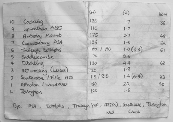 [/IMG]
Ride to Peaslake and just do laps of Barry Knows Best?
Thanks for the tips. Feel much more positive about that route than the whole thing.
Kingsclere to Combe Gibbet, along the Wayfarer's Walk?
@adsh - get some routes on your GPS. I find the Surrey Hills pretty easy to navigate but appreciate there is scope to get lost. As @deadkennedy says you can put together a training ride (so no super secret dh trails) using bridleways / known trails / roads very easily. If you want max climbing you could go up/down Ramnmore/Leith/Holmbury twice.
Thanks for the tips. Feel much more positive about that route than the whole thing.
Yes it's easy to navigate.
However a word of warning - I haven't wanted to cry on a bike since the last Brass Monkeys but I did feel a slight moistening around the eyes for about 2hrs at the end yesterday - it's just relentless.
One of the advantages of the SDW when the weather is good is the views... well worth it!
Local road route with some nasty hills in it:
Torture 40
John Hollands Torture 40 to give it its full title. A great route could easily add some more distance and hills to it.