Can anyone point me in the direction of some good mountain bike routes on Skye... preferably a couple of 30-40 milers and a shorter loop.
Staying at Skyewalkers Hostel so would be good to have something to ride from the door or with a short drive
Heading up this week to take a look around...
paul.e
I am also interested in this, can you post any routes when you get back?
Right, this will not be much help, but you want to ride down Glen Sliglachen. I'm sorry to say that is the only info i can give you, think it was featured in MBR years ago. I last went in 2005, and was only 16 so didn't pay much attention to location 😆 Just remember it being an epic ride! One of those rides you never forget, especially for the views, you have to stop, and just look around for a while. Was amazing!
Apart from that, sorry, can't help much 🙄
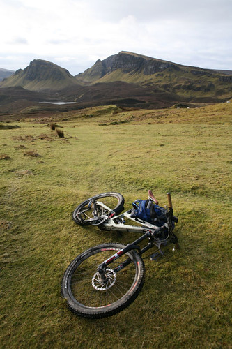
Give you an idea of what i mean, a shot i found on google images:
[img]  [/img]
I did a few long rides (50-80 milers)
The Sligachan loop is nice (in bits) pretty simple nav but get a map anyway just in case. Go to Sligachan hotel, theres a wee old bridge , cross that, follow obvious path up Glen - go right up the glen and over the saddle towards Camansary (? rings a bell) thn head out of there up 4wd, out onto B rd, head back N then cut through the other wee glen at the bridge before you swing SE again. Its in a guide book. You then end up on the main rd but its not too busy.
Basically i found most of the marked rtracks were rideable.
I went to skye biking last month, didnt do the Sligachan loop due to the weather and time really 🙁 However we did the the Quiraing loop which involved alittle road, but mainly single track riding. Id recommend it, although i will only take a few hours.
Couple of shots

oh, and the route [url=www.bikehike.co.uk/mapview.php?id=3128]Staffin/Quiraing Route[/url]
Meant to be some biking on Raasay I believe.
Try this link
http://www.mountainbikescotland.com/routes/sligachan.html
Looks like theres a new book coming out soon as well
Thanks Guys
Gonna do Sligachan loop on friday...
didmatt, link doesn't work and that sounds like a good route for saturday
thanks again
I did the Sligachan loop in the pouring rain and it was fab but v technical. One good thing is the water bars across the track are about 26" wide - so my 29er rolled over them 😉
Paul78: try this, sorry i posted the link wrong.
www.bikehike.co.uk/mapview.php?id=3128
didmatt,
thanks... does route run clockwise/anti clockwise???
what sort of distance is it??
Pual78: We did the route clockwise and its about 7miles, if you look at the map you can start from the carpark at the cemetery and go on the single track opersite and join the ridge further along. This cuts out the steep road climb onto the ridge where you could also park the car up. However even doing this requires abit of a push up onto the ridge.
Thanks for all help guys..
Just finished blogging the trip..
http://shoestring-racing.blogspot.com/
Great place and great riding
Nice write up that Paul. I rode the route a few years ago during a long dry spell and the singletrack alongside the loch at the start of the ride was still a bog!
Nice write up and pics Paul, it was no problem giving you the route. We also got alittle lost towards the end when the route seems to split about a mile from the road! We also ended up jumping the drainage rocks, however it caused my friend to burst his inner tube!