There's a stretch of beach near which would make a good link on a fatbike route. Its about a mile long but marked as private. It has a fence down the beach to the high tide line. It also runs past the posh hotel and house which owns it so its quite obvious if anyone strays there.
Is there a limit to how far out to see their boundary extends? At low tide there is quite a lot of beach exposed, was wondering if its OK below high tide line or something.
If it's in the UK, all land between low & high water marks is crown owned, & open to the public. So if the tide is out, you can use it.
IANAL
Where is it? Can we view it on googleearth or similar?
What Moses said - below high tide, they can go jump.
Is this England?
Nude ride in the offing.....?
As above. It catches a lot of people out in land ownership disputes!!
Nude ride in the offing.....?
En-masse with a stop to admire view, or solo at breakfast time with some Pilates mid-beach?
Its between Calshot and Lepe in the Solent
[url= https://www.google.co.uk/maps/ @50.8007465,-1.3365851,3913m/data=!3m1!1e3]Google earth link hopefully[/url]
Edit - no way I'm riding nude round there in this weather!
All quite stoney from distant memory (as a kid on Calshot) and towards Lepe spit quite steeply shelving ? Again from memory I don't recall too much which would really be private. Will check OS now 🙂
Beautiful sunny day today down here by the way (posting from Hamble)
From the Google images, it would appear that those fences are preventing access to the beach between the high water mark and the low water mark. I'd be having a word with the council/ access office / Crown Estate
@scot - do you mean the Groynes ? Those are to protect the beach from erosion. As a landowner you have no obligation to allow access across your land
Edit: OP Luttrels Tower is quite a cool Landmark Trust Property [url= http://www.landmarktrust.org.uk/search-and-book/properties/luttrells-tower-11322 ]linky[/url]
Not the groynes. If you look closely you can see two fences extending across the beach (shadows seem to show the fence posts).
I get the bit about not having to allow access across your land but surely the bit between HWM and LWM isn't the landowners land?
@scotroutes - yes agreed, you shouldn't build a fence between high/low water unless you have permission
EDIT my guess is that the "fence" you can see on google is alongside a slipway marked on the OS maps ? Not sure
[img] 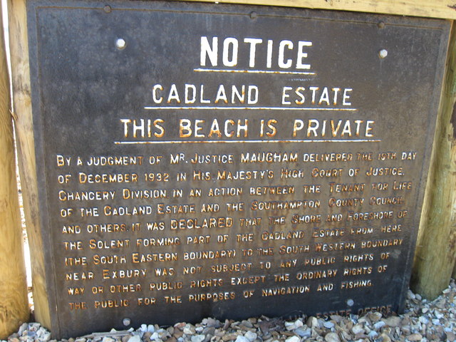 [/img]
Does this change anything, mentioning shore and foreshore?
Jamba - we're riding the beach on Sunday from Weston to Hamble, over on the pink ferry, all the way down past Lee on Solent to Gosport. And back. Makes a pretty good beach ride, and plenty of pubs en-route (King and Queen a favourite, good cider there)
Should be able to see the fenceposts here
[url= https://farm6.staticflickr.com/5823/23926427385_39e10e26b4_b.jp g" target="_blank">https://farm6.staticflickr.com/5823/23926427385_39e10e26b4_b.jp g"/> [/img][/url][url= https://flic.kr/p/Csich6 ]Fenceline[/url] by [url= https://www.flickr.com/photos/druidh2000/ ]Colin Cadden[/url], on Flickr
just pedal faster
Easier to ask forgiveness than permission 😉
Enjoy 40. I often do simple loops up and down Hamble and along towards Lee. BFe not a particularly good choice for shingle though and I don't like to get my preciuos too near the salty water !
[img]  [/img]
Looks from 40mpg's photo of the sign that for some reason the estate has the rights for the foreshore too (MHW to MLW). I wonder why.
scotroutes - this is England, not Scotland. In England the crown(us?) normally own from the MHW (not the spring MHW as in Scotland). As we have no way of knowing the state of the tide or if was springs or neaps at the time of the photo I don't think we have any way of referencing if the fence line marks the MHW or not.
[quote=convert ]scotroutes - this is England, not Scotland. In England the crown(us?) normally own from the MHW . As we have no way of knowing the state of the tide or if was springs or neaps at the time of the photo I don't think we have anyway of referencing if the fence line marks the MHW or not.Yeah - I was using the OS window of wheresthepath to determine the HWM but I reckon it might not be quite accurate enough.
Interesting notice though. I'd be fascinated to hear more of the case.
What Moses said - just be prepared to pedal really quickly if you see any chariots, as this means that the tide is coming in... 😉
[img]  [/img]
25k map shows high and low water (bottom and top blue lines). Little space between: suggests quite steep.
A very careful comparison of the satellite data and OS data on Bing might show you where the fence ends, but might not be accurate enough given the small space.
Fling the sign in the sea, then you wouldn't know it was private 🙂
And if anyone stops you, tell them you are carrying on your journey and they best call the cops if there's a problem with that.
I'd just go for it, if you're not hanging around looking shifty then chances are nobody will give a toss. Remeber, everyone loves a fatbike.
Try this for the map http://www.natureonthemap.naturalengland.org.uk/MagicMap.aspx
That sign says you can use it for navigation, so navigate your way across it.
HTH
Carry a fishing rod.
[img]  [/img]
As a Venture Scount in the mid-eighties, we bumped into Lord Montagu while trespassing near there. Kind of interesting, considering his notoriety, not that we knew any of that then. He was quite annoyed but softened up when he saw my mate in a wheelchair. Was near what looked like a summer house - not sure if that's Cadland.
We were definately trespassing though.
This fat bike thing sounds like a laugh - hope you enjoy your ride.
Sign seems to nail it. Gave it a quick Google but found nothing.
The case report may be findable by lawyers...
Remember, everyone loves a fatbike.
Print this on a card and wave it as a 'pass' at anyone who complains!
It looks like the estate, rather unusually, has claim to the foreshore and the public has no rights, though there is a bit about the ordinary rights ... navigation and fishing.
I'd just ride it, if you really want to. They'd have to get an injunction or take some civil action to stop you, anyway. They can't just chuck you in the sea.
That area is also a bird sanctuary, ride between mean high water and mean low water and you'll be fine, should be good for a giggle.
If you're down Hamble way again, Warsash to be precise, giz a shart eh...
Also, try riding from Lepe round to Bucklers, over the river then round to Lymington and catch the train back. I did that on the CXer and it was ace, much better on a fatty though.
[quote=Moses ]If it's in the UK, all land between low & high water marks is crown owned, & open to the public
As soon as I read this I was going to pedant that it wasn't accurate, as it doesn't apply to all land, there are some small parts which aren't. As soon as the location was mentioned I started wondering, because I knew one of them was in that area. Looking at that sign it may well be there.
Here we go:
http://www.publications.parliament.uk/pa/cm200708/cmselect/cmenvfru/656/656we40.htm
though according to that they do allow public access to the foreshore
I have nothing useful to add, but at last an access thread that doesn't involve bridleway vs footpath!
Well found aracer
I'd like to see the owner try to sue you for damage reparation if you ride between the high and low water lines 😀
As pointed out in: http://www.ukriversguidebook.co.uk/forum/viewtopic.php/f,4/p,478054/ all you have to do is ride through the water, as when it's covered by water the status changes.
Agree may be difficult to get sued but annoying the owner does little for the greater good of the sport especially given the existing fragile relations in the forest. Equally if I read the link on aracer's post right then there are fragile marine species there that merit not being ridden or walked all over. If it's legally permitted access them fair enough
Sign says 'Not subject to any rights of way or other public rights [b]other than the ordinary rights of the public for navigation[/b]'
So it's not a footpath or bridleway (nor are most beaches) but you still have your 'ordinary' right to navigate across below the mean high tide mark.
Aracer, thanks for that info. Although that was penned by the estate themselves it does indicate its an environmentally sensitive area and may also be a safety risk under unstable cliffs (although these are only a couple of metres high at most if I recall.
May have to have a closer inspection by kayak to see if the above appears true and if its worth riding.
If it was me, I'd ride it but be sensible and not rude over the kelp or two plants they mention, and no knicking any shellfish snacks en route......just practice a foreign accent and act dumb 😆
Looks like were going to get access anyway (on foot at least - cheeky trails at best)
[url= http://m.dailyecho.co.uk/news/14193574.New_coastal_path_to_link_Hampshire_with_the_rest_of_the_UK_s_coastline/ ]clicky linly[/url]
