I put a photo of the Nan Bield Pass on farcebook yesterday after a cracking ride down it. Sure enough, I attracted a comment from a distant uncle-in-law who appreciates the scenery in my photos but frequently belittles the alleged erosion caused by bikes.
I'd like to respond with some fact that the famous switchback path is an ancient pack-horse trail and as such is so well built its not eroded at all from bikes or boots for over a century. But I've no idea if that's factually correct. Anyone have any idea on local history?
[img]  ?oh=b7d7df4fe8df85a7c77bdb4205df6d03&oe=57734C21[/img]
I'd just unfriend him 😀
Historic trade route from Mardale to Kentmere apparently
There have been people in Kentmere valley since the Neolithic age, so I think it's had one or two people, mules, horses and the odd mountain biker go up and down it since then.
Not as much damage as flooding the valley to create a reservoir 😯
According to [url= https://en.wikipedia.org/wiki/Mardale_Ill_Bell ]Wiki[/url]:
"[i]Nan Bield was the ancient trading route between Kentmere and the now drowned village of Mardale Green, submerged by the raising of Haweswater in the 1940s. Near the shore of Small Water on the descending path are a number of stone shelters, pointers to the earlier importance of the pass. These each provide refuge for one person in extremis, entrance being via crawling.[/i]"
Does said uncle just like the pics from his armchair or does he get up close and personal with these places using non-eroding hover techniques?
If the former then tell him he's imagining most of the erosion and if the latter tell him to do-one as he's part of the problem.
Lake District is chock-a-block with badly eroded footpaths that have never (ok very rarely 😉 ) seen a bike
1922 - looks to be a pretty definitive track:
[img] 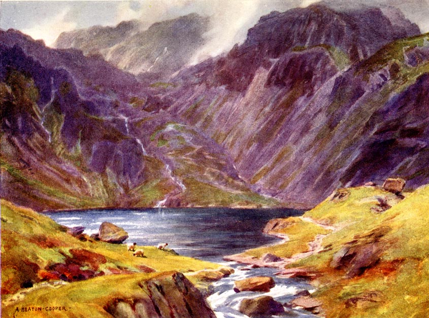 [/img]
From Wild Lakeland, by MacKenzie MacBride illustrated by Alfred Heaton Cooper, published by Adam and Charles Black, London, 1922-28.
http://www.geog.port.ac.uk/webmap/thelakes/html/lgaz/mb0103.htm
----
Also marked on a map from 1770:
[img] 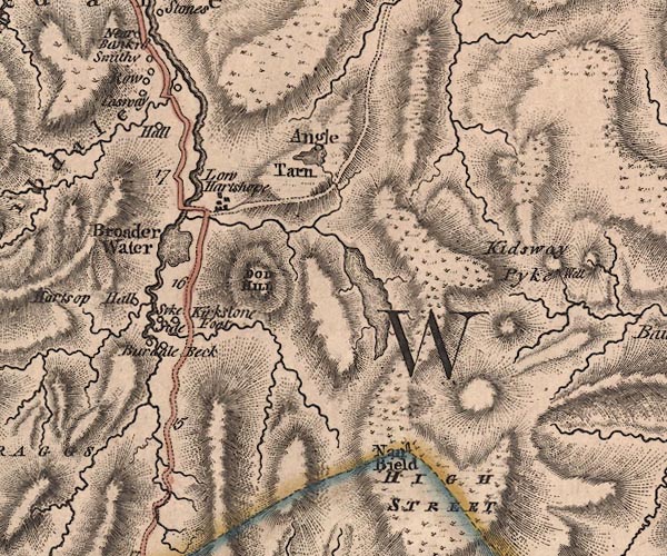 [/img]
Map, The County of Westmoreland, scale about 1 inch to 1 mile, surveyed by J Ainslie and perhaps T Donald, engraved and published by Thomas Jefferys, London, 1770.
http://www.geog.port.ac.uk/webmap/thelakes/html/lgaz/j5ny41sw.htm
sure theres a bloke on a penny farthing in the picture by Alfred Heaton Cooper. i blame him.
How did you enjoy the ride up from the top of Garburn over ill bell to nan bield then?
A lot of the paths/bridleways in the area, certainly around Mosedale Cottage and leading off High Street, are old corpse roads. Nan Bield could have been the connection from Kentmere onto these routes, heading to Shap
I've just found Wainwright's pencil drawing of the pass, complete with zigzags. Can't argue with that.
Nobeerinthefridge: Mental! Top of Ill Bell was a bit too far out of my comfort zone, but the rest was awesome. Loved the off-camber around Froswick.
Every single thing in the entire universe is eroding...........live with it!
There's a submerged church in Haweswater, hence the link from Swindale, and Kentmere has it's own church as does Longsleddale, so Nan Beild almost certainly a trade route. High Street was roman road, they travelled above the tree line to avoid ambush from the Cumbrian savages 🙂
Sensible folk.
Used to rub their legs with nettles to stay warm too
It was opened in 1994 by Dot Cotton as a tribute to her friend and the mother of Pauline and as a means of ferrying laundry from wet sleddale to ironing keld. However over the centuries the tonguetied inbreds have destroyed the original cockney pronunciation in favour of something that can exhaled as a primordial grunt. Nowadays most of London's dirty clothes are sent to primark to be sold to the poor and as such the route has fallen into ruination, in fact the only thing keeping it compacted is the regular compression by tyres of vertiginous topography cycles.
just tell him you were walking with your bike on the rough bits 😉
Nobeerinthefridge: Mental! Top of Ill Bell was a bit too far out of my comfort zone, but the rest was awesome. Loved the off-camber around Froswick.
Cool, glad you liked it! Two of the three times I did it last year were picture perfect clear days, the views from the broad ridge heading north are hard to beat anywhere IMO.
Ill Bell .... gets maps out
Jamba, if you want a GPX, gimme a shout.
Best done as a decent big day from Ambleside IMO. There's a bridleway down past the turning for Holbeck Ghyll that takes you over to Troutbeck.
From there, up Garburn to the top, then keep going onto Yoke, Ill bell, Mardale Ill bell, froswick, then you can either go round the nice contouring singletrack to the east, or carry on up onto thornthwaite for awesome views.
Then down to Nan bield and into Kentmere. Here you have a choice, if you're goosed, go over High Borrans to troutbeck then down Jenkins crag to Ambleside, if you've still got juice in the tank, add in Long houses up onto Staveley head fell and the three rivers descent too. Then High Borrans onto Jenkins crag.
Tis a fine days biking indeed.
if you're goosed, go over High Borrans to troutbeck then down Jenkins crag to Ambleside,
We went back over Garburn PAss to Troutbeck. Good fun blasting down the other side, but not much fun going up from Kentmere. Jenkins Crag was superb 🙂
Nobeerinthefridge > Any chance I could pester you for that GPX please as im up there in 3 weeks
Thank you
Aye, my email is on profile, yours isn't! pop me an email and I'll send it to you.
Similarly to OP I get grief of the father inlaw, who was a keen rider in his day, still does a lot of walking, if I so much as mention I've been anywhere near a decent be it legal or otherwise in any part of the lakes he gives me grief.
So now best policy is keep quiet smile & enjoy the ride.
Nan beild is a favourite of mine, start at Ings over the Garburn to kentmere & onwards for a days fun.
For those struggling with people thinking bikes are a major cause of erosion, give them the science:
https://www.imba.com/resources/research/trail-science/natural-resource-impacts-mountain-biking
The conclusion from all the peer reviewed, irrefutable science on the matter is essentially that walkers and bikers cause similar amounts of erosion per user, but the much greater number of walkers means they as a group do more damage. Wildlife are also more scared of walkers as they pass more slowly, and often more loudly if in a group and talking. And anyway, compared to the effects of horses and that biggest evil of all, rain, the impact of bikes is minimal.
