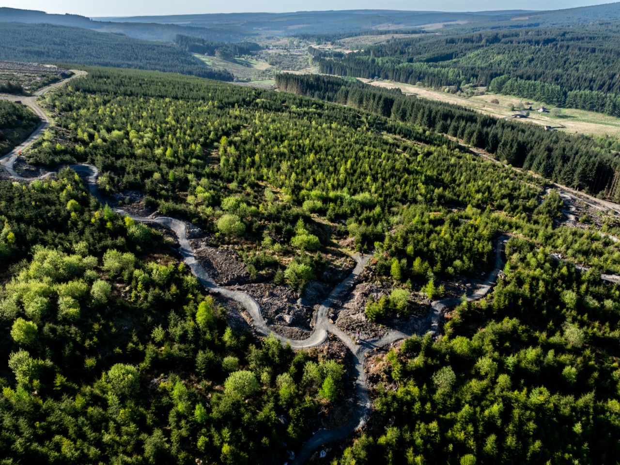
Eventually it will be 1.69miles long, but that’s not such a catchy name – the new Mile Down trail at Kielder is a firm reminder that it’s not all gravel riding in that corner of the world. Here’s the official press release to mark the opening:
The new “Mile Down” trail at Kielder, createdin collaboration betweenForestry England, Velo Solutions and Northern Downhill (NDH) is a new, red-graded trail with both black and double black diamondoptions.
This new trail complements the new Blue mountain bike trails of the Lonesome Pine trail in Kielder, the Reivers Gravel Trail Network, and the 26-mile Lakeside Way, underlining a reinvigorated approach to the trail network in the UK’s largest forest.

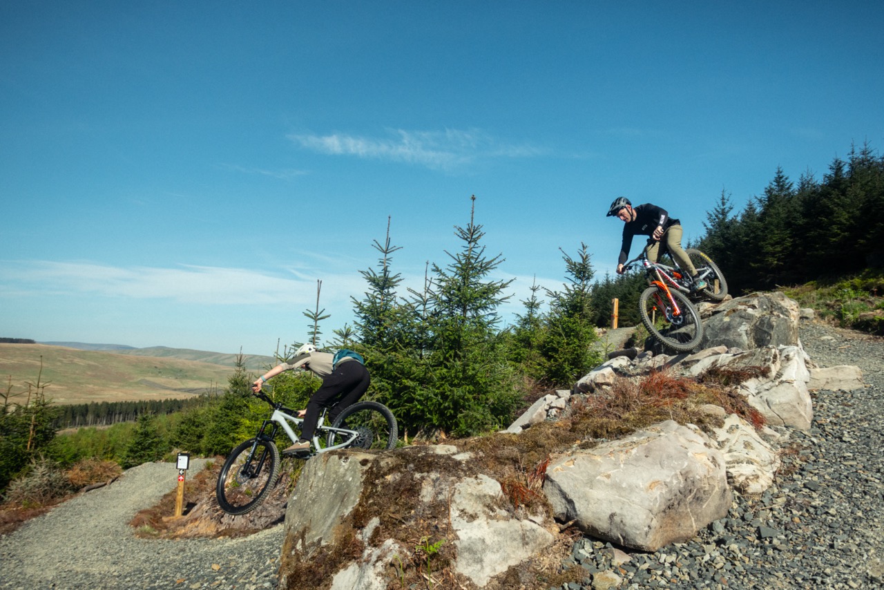
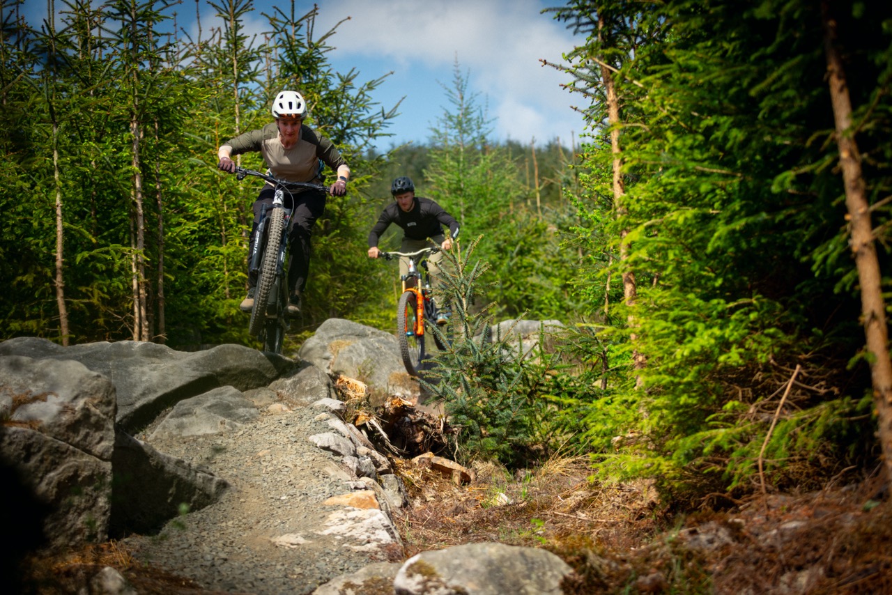
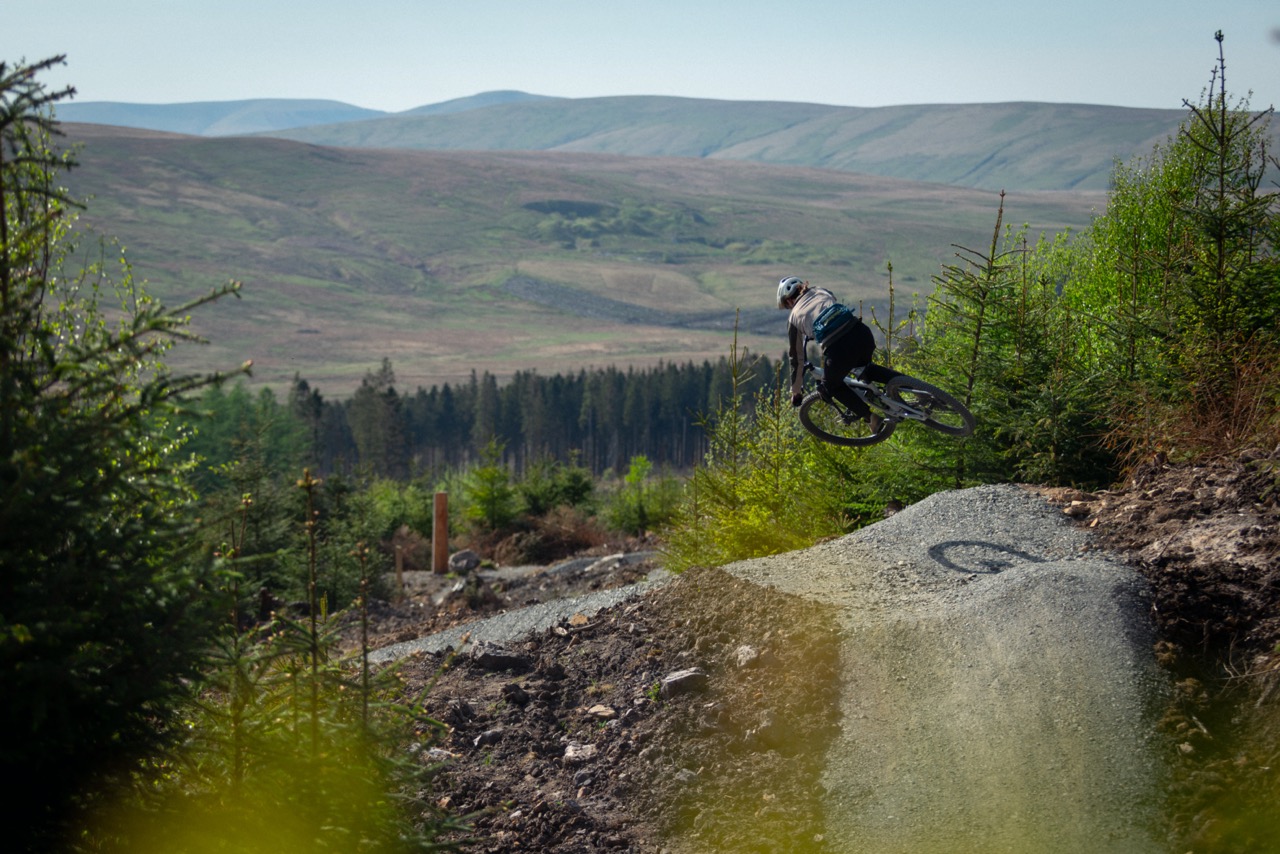
The lower half of the Mile Down Trail is now open, with international riders Manon Carpenter and Adam Brayton joining riders to bed in the Velo Solutions-created section, which offers a truly progressive riding experience – As Manon says “They’ve packed a lot of fun riding in with cool rock features, flow, jumps and techy sections. Great to ride and to see new trails on offer!”. Adam Brayton was visiting Kielder for the first time, making the 2-hour drive from Cumbria, and was suitably impressed ” Mile Down is a superb addition to Kielder’s trail network. It really does have something for everyone, and I genuinely can’t wait to come back once the top section is open!”
The full trail will be open in the comingmonths, and at 1.69 miles in length claims to be one of the longest downhill trails in England.
Alex Maclennan, Recreation and Public Affairs manager:
This is such a key milestone for Northumberland; 20 years in the thinking! Carl Davison, Phil Grimes from NDH and myself held close that one day we would deliver one of the longest downhill trails in England.
Back in 2005 it was quite a challenge to set out how we would deliver the Kielder cycle trail network, back then there was no singletrack- mainly due to the very challenging ground conditions of deep peat!
Since then the evolution of the 26 mile Lakeside Way (multi user trail), Osprey, Lonesome, the newly upgraded more inclusive Lone Star, Bloody Bush and Deadwater in addition to the newly createdwww.reivertrails.comnetwork is something we are all proud of.
For a number of us, the missing chapter was the trail sections we opened on 7thMay, a higher grade of technical trail. When completed in the coming months, the top section of the Northern DownHill Descent trail (rightly named after all the amazing work put in by the volunteers from NDH), we think Deadwater can final claim to be one of the longest downhill trails in England.
In collaboration with the Kielder Water & Forest Park Development Trust, Northumberland County Council, Visit Northumberland and wider partners of the north east over the last 20 years who have all supported the cycle trail developments at Kielder, I do feel quite humbled and honoured. This is a key milestone for the region.
In partnership with Team Cycles who now operate the Kielder Cycle Centre, I believe this is Kielder’s time- the nations largest forest where you really can get away from it all (and even stay overnight in a camper van!). Kielder can now rightly claim it is the venue for every level of cycling and all disciplines in the UK, including miles of road cycling on the roads to Kielder across both sides of the border.
We must not forget all those who have helped get us where we are today, Kielder Trail Reavers volunteers, event organisers – large and small – and also our local communities and local businesses, hard-working forestry staff who make it all happen behind the scenes.

Jack Hyde,Construction Manager,Velosolutions UK
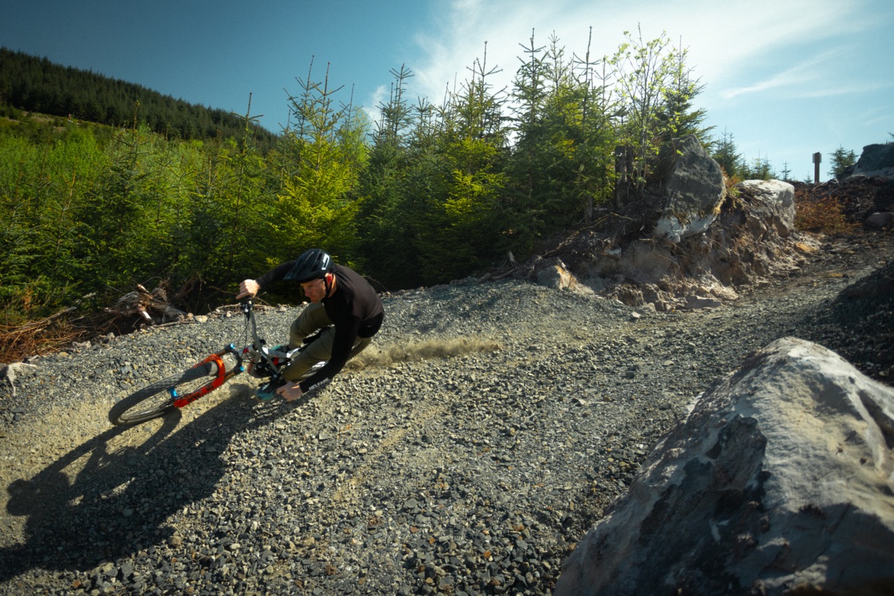
Velosolutions is proud to have been part of bringing the Deadwater Mountain Bike Trails to life. This project presented some serious challenges, from machine- swallowing ground conditions to navigating glacial boulder fields but that is what shaped the trail you see today.
Opening day was a truly special moment. Seeing so many riders out there enjoying the trails was a reminder of why we love this sport. It’s amazing to witness people connecting with the outdoors on something built by the hard work and dedication of so many, over the years.
A huge thank you to Forestry England and everyone who contributed to this journey. We’re proud of what’s been created and can’t wait to watch the Kielder riding scene continue to grow!
Kevin May,Forest Management Director (FMD) for North England Forest District:
A great partnership between Forestry England and Velo Solutions has excellently delivered a long-standing vision for Forestry England and in particular, for my colleague Alex MacLennan. The Kielder Forest Deadwater ‘Mile Down’ Trail – with route options catering for all between red, black and black double diamond. Opening the trails were Manon Carpenter and Adam Brayton two of the UK’s top DownhillMountain bikers who have competed at the highest levels across the world…and importantly, both excellent ambassadors for the sport. Riding with such amazing athletes and a wider mountain bike community was a sheer pleasure, with the weather making it the perfect day. For me, a perfect mix of business and pleasure with a love of mountain biking, only surpassed by my love for the Nation’s Forests. With more to come for this trail in the autumn……


I’ve been so confused by this so far, it keeps being referred to as a downhill trail but from all the photos I’ve seen it looks like a trail centre cross country trail. Great to see something new being built there though, always felt it was missing something.
That actually looks pretty awesome, love it when they go for “packed in trails" rather than “we have opened 10 new miles with nothing to do on them". Kielder definitely needed something, will need to get down there when it’s all open. Has anyone seen a map showing how (if?) it ties to the old trails?
If I understood it right it’s a “downhill trail" but almost using the logic of a golfy offpiste or similar, pedal up and ride down. Haven’t seen how it ties into the old trail centre, that’ll be pretty important I think.Always wanted to like kielder, it has some really good stuff and it’s characterful. I like the looks of this a lot, seems intended to really pack stuff in and make the most of the altitude instead of focusing on distance.
It’s near to the Three Dogs trail, but runs down the hill rather than traversing. It will link with the DH trail that comes off the top of DeadWater fell which runs sort of parallel to the existing trail centre trail to get the full length
Not sure that referring to it as Double Black Diamond DH is strictly accurate though…
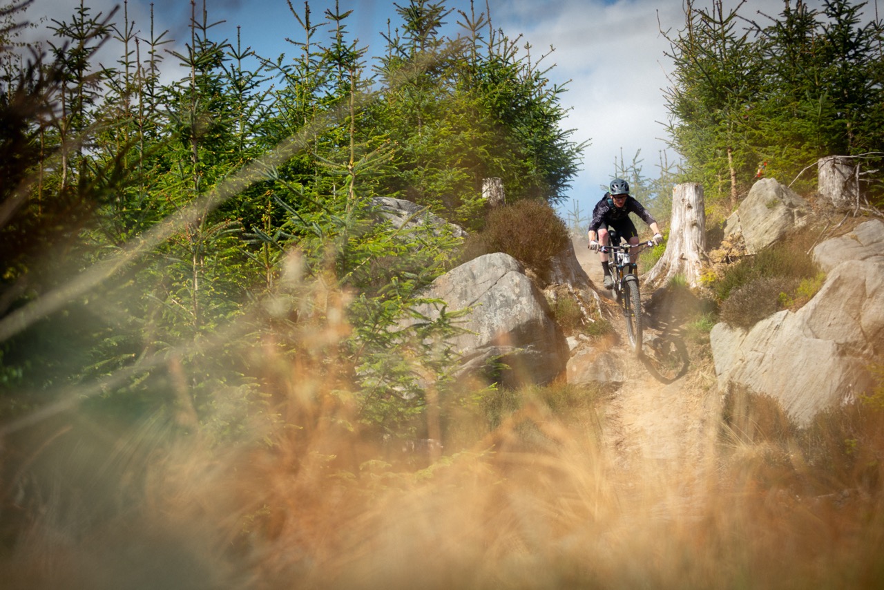
Been up 2day, new stuff is a red jump line and a ‘double black’ line which is the old NDH DH track from years ago and has had a lot of work done, to be honest its better than i was expecting but doesn’t really link into the other trails on Deadwater hill. It’s VERY dry and loose at the minute and the top bit of the NDH track is still being worked on but it’s something different to the rest of the trails at Kielder, once the top part is open it’s basically a mile long descent on varying terrain, bit of everything with the option of a jump line or a rocky tech line in the middle, more of a long enduro stage than a modern dh track
So, is the bit from the radar station going to be part of the downhill section? I did it on Thursday, that bit down is just a rough fireroad now. Then, the trail seems to stop at a large fire road,after ‘For peats sake’ and some newish downhill sections. then take a right and its uphill to the new section. Is that the way its going to stay, or is it going to be one long DH section from the radar?
There’s a turn off on the right just as you get to the treeline on the fireroad from the radar statì but it’s closed/fenced off for rebuilding at the minute, will link straight into the new stuff that’s just opened and was pretty hard/ techy the last time I rode it a few years ago. Hopefully they will put a climb push up to the start , as already mentioned the long way up is horrendous
Oh yes, my first time there on Thursday, I made the mistake of going up to the radar station, following the ‘Black’ route signs. 45 minutes later , I was a little more than rather disappointed.
Adam Brayton has a vid on YouTube that shows the new stuff, I’d post a link but can’t
The radar station descent was great in about 1994 – before they built the track up the back of the hill and before suspension worked. Will have to head up some time to check out the rest of it.
I rode it yesterday, there’s still a fair bit of fire road but the new trails are good. The red needs to bed in, and not really my kind of track but the black is probably the nicest bit of piste trail on any trail centre map. It’s been there a long time to be fair, but it’s had a lot of work. The map isn’t great though. As you climb up out of Two Dogs Climb and turn left you get to a T junction. The map looked to us to send you, turning right, up towards the old red. We couldn’t see the new trail as we climbed past the old red so we ended up climbing the hateful climb to the radar station looking for it, wishing I was on an ebike. It was there, so we felt robbed as we descended down the old top firewood…
Instead, we should have just turned left at the map, and both trails are about 200m away… If you finish on the black, it’s a bit of a slog along the tarmac back to Kielder Castle.
Great to see investment there, I hope there’s a little bit more if we all use it.
Edit: You could make a decent lap by doing the old red, then climbing up to do Two Dogs again and the new red, followed by Two Dogs and the new Mile Down Black. We didn’t find the Double Black, unless tat’s what Mile Down is?
I mean, that looks a lot like gravel in the pic 😉
Rode it on the Saturday before the official opening. Just happened to be riding there for the first time since 1993!
There was a group ride heading up there with the trail manager and they invited me to join. Was great fun!
The mapping at Kielder is absolutely awful. There is just no ‘route’ to it. Just a section of tracks that you have to make work yourself.
There was this one bit of old red climb which I thought had a black section on it – looked fun, so I followed it and it turned out to be a completely different trail that ended up in a completely different section of the forest!
Anyway – the new sections were great. More bike-parky than traditional 7-stanes fare.
I don’t think any of it should be graded double-black, but then I’m not sure the signs mention that anywhere – just Black and Red.
There was this one rocky sharksfin that nobody wanted to test and they were going to chop the top off it before Adam and Manon arrived. It was soooo blind. Anyway – sent it and didn’t die, but they definitely needed to do something to stop people hurting themselves on it.
My fave bit was the black parallel to the red. Nice and raw and sandy with techie rocks thrown in. Mostly wheels on the ground and it was perfect.
This is the jump.On first glance, you’d think it was a jump to the left!But you actually have to go fairly strait.You can see some lines I scratched on the top to mark where I needed to jump.
The lip was really kicky. So I think looking at Adam’s video, they’ve chipped off that top triangle.
The last section of the old NDH track is graded as black (it would probably be a red in other parts of the uk), I think the middle section is graded as double black ( could be just a black, can’t remember) but they appear to have already fenced off a large gap jump off a tree stump near the bottom, the top section which isn’t officially open yet will be a double black. The top was definitely a lot harder than the lower sections I rode on Saturday last time i did it, very rocky/techy and is probably longer than the 2 lower sections combined. It is, as already mentioned, basically a handful of trails on a large hillside, doesn’t really work as a traditional trail centre ‘route’