- This topic has 31 replies, 12 voices, and was last updated 6 years ago by felltop.
-
Scottish Highlands – Poolewe
-
singletracksurferFull MemberPosted 6 years ago
I’m off to the Scottish Highlands later this year, on what seems (and hopes) to become an annual thing. I’ve done a number usual suspects, Torridon, Ben Damph, Isle of Skye, Applecross, Kintail, etc.
So the plan is to head up to Poolewe, as Fionn Loch was fun, so I wanted to find out what condition the Tollie Path is in, as it was pretty dire in 2015 by all accounts. Also what is the out-and-back to Loch na h-Oidhche like? Any other suggestions for there and upwards welcomed too.
Thanks very much.
scotroutesFull MemberPosted 6 years agoLoch na h-Oidhche is a worthwhile trip. The track gets progressively rockier along the lochside. The bothy is now closed though.
whitestoneFree MemberPosted 6 years agoI Can’t imagine the Tollie Path having been improved as Alan G kept it out of this year’s HT550 using the Postman’s path between Letterewe House and Kinlochewe instead.
The Postman’s Path might be worth doing: Fionn Loch path to here then take the path south to Letterewe then the path to the bridge here The first part might be a bit overgrown with bracken now – it was OK at the end of May. It’s either road or a lift to get back though.
A bit further round the coast at Dundonnell there’s a loop on the northern side of Fisherfield from Loch a Bhraoin round to Corrie Hallie. I’ve done part of this but have seen reports of the other sections.
Further north ( a lot further north) you could look at the Bealach Horn loop from Achfary. Park here along the estate road to Lone then take the old stalker’s track E to Gobernuisgach Lodge then up Glen Golly on the stalker’s track to here some hike-a-bike downhill! then up the track on the other side to Bealach Horn and a brilliant fast downhill back to Lone.
DavidBFree MemberPosted 6 years agoDO NOT do that last loop proposed by Whitestone if it has been raining a lot recently. “some hike-a-bike downhill” will be a euphemism. I’ve done this twice in bad conditions and it is simple purgatory.
whitestoneFree MemberPosted 6 years agoNot really a euphemism as it’s quite accurate. I’ve done the Glen Golly – Bealach Horn – Lone section twice this year, the first time there was snow on the bealach and a bit squishy generally, second time was quite a bit drier. Both times were with a bike loaded with bikepacking kit (see third shot). I’d say that about 80% is ride-able.
Some shots:
The quad bike track in Glen Golly

On the stalker’s track
The HaB downhill
Someone on the second trip (the HT550) mentioned that he’d done it in boggy conditions and it was about an hour slower than when dry, this was Merkland to Lone rather than the above loop.
OP: if you see a track marked on the map then it’s worth checking Geograph to see if there’s any shots of it though often the photographer is more interested in old farm machinery than the state of the track. Another site worth looking at is Heritage paths. Expect some Hike-a-Bike though!
One track to avoid is the one between Lochinver and the road at Ledmore that goes past Suilven and through Glen Canisp. Starts out OK but the second half is just about all HaB 🙁
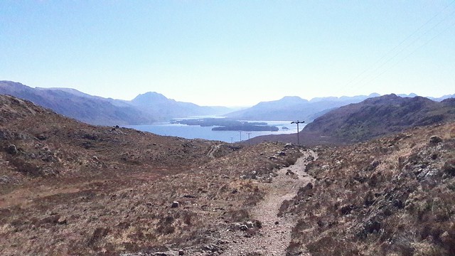
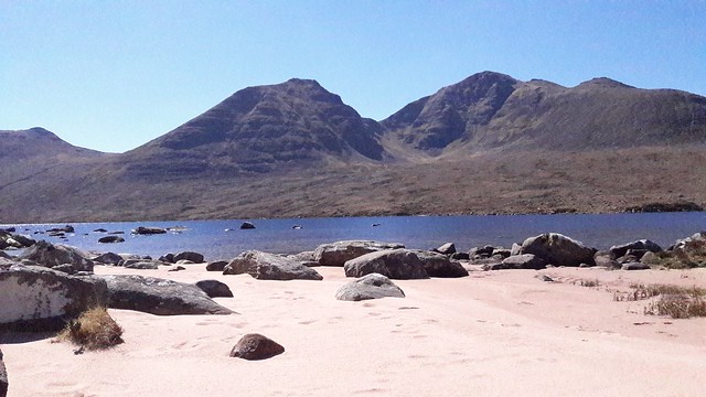
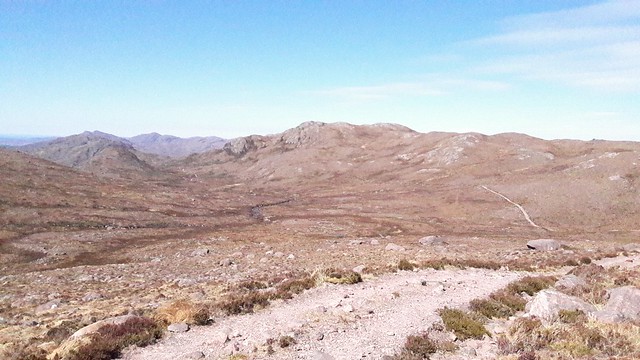
hairyscaryFull MemberPosted 6 years agoI rode the Tollie Path and the Loch-nah-Oidhche out and back as one ride, starting at Gairloch, earlier this year. The Tollie Path is not in that bad shape with only a couple of get off and pushes from me.
For me the riding was about the views. Sorry about the poor quality of the camera phone pictures
Tollie Path
Loch-an-Oichdie
Path to and from Loch-na-Oidich
scotroutesFull MemberPosted 6 years agoMatt – is the big gate on the L-na-O track still locked? Last time I was there I couldn’t get through the walkers gate with my bike but found it was just on pin hinges so lifted it off and pushed my bike through 🙂
singletracksurferFull MemberPosted 6 years agoBrilliant, thanks for all the advice so far.
Tollie sounds like it could be OK then, and the Loch will be worth a trip too. I’ll have a look at the map this evening and hopefully work those other recommendations into my plans too.
singletracksurferFull MemberPosted 6 years agoWhitestone, do you have a gpx for the route further north, I’m having trouble working out where you mean to go exactly. Thanks.
whitestoneFree MemberPosted 6 years agoIf you follow the links in my post you’ll see the various junctions (there aren’t that many). While you are doing that I’ll figure out the GPX side of things.
The loop is in the Wild Trails Vol 2 guidebook, page 65.
hairyscaryFull MemberPosted 6 years agohttps://www.strava.com/activities/380628593
I don’t know how to do GPX stuff, but that is a link to the ride around Bealach Horn that I did in August ’15…….although I started from Kylestrome and added a wee bit more.
There will also be the Tollie Path and Loch-na-Oyde ride from May this year.
If you can’t see the link send me a follow request. Edit….assuming you are on Strava 😀
Matt
chickenmanFull MemberPosted 6 years agoFor me the highlight of the Fisherfield area has to be the mile of perfect white quartzite to ride down. On Sgurr Ban as part of the Loch Bhraoin loop decribed above.
 [/url]DSCN0686 by rick.campbell, on Flickr [/img]
 [/url]DSCN0682 by rick.campbell, on Flickr[/img]
 [/url]DSCN0668 by rick.campbell, on Flickr [/img]
 [/url]DSCN0659 by rick.campbell, on Flickr [/img]felltopFull MemberPosted 6 years ago
Tollie path hasn’t got any better. Postie path along Loch Maree was the scene of epics on the HT550, and will only be harder in the wet with head high bracken!!
Otherwise there are some good suggestions on here. Also consider riding from Kinlochewe to Loch An Fada.
Up the road from Poolewe at Gruinard Bay it’s worth riding the track up the Gruinard River.
If you can organise the logistics, the “Trans Fisherfield” from Corrie Hallie to Poolewe is a proper big day out.
Get in touch if you want company on a ride – I’m just up the road from Poolewe.
singletracksurferFull MemberPosted 6 years agoWow, is that white quartzite bit on the trail or do you venture off to go up it to come back down?
Is the Tollie path/Gairloch route still worth a ride though?
Think I have that guide book actually, somewhere, so will hunt it out.
Hopefully going in October again. Had some fab weather in the past then and no midges.
scotroutesFull MemberPosted 6 years agoIt’s off the trail.
https://www.google.co.uk/maps/@57.7183275,-5.2298468,8849m/data=!3m1!1e3
whitestoneFree MemberPosted 6 years ago@felltop – is the loop from Kinlochewe via the Abhain Fhasaig to Loch Fada and back via Glen na Muice worth doing? Or the opposite direction.
The Postie’s path was a bit Marmite on this year’s HT550, some loved it, some (including Neil Beltchenko) didn’t. I liked parts of it but, let’s just say, had a sense of humour failure on certain other bits!
On the HT550 I took 11hrs from Inverbroom to Kinlochewe with one or two short stops such as at Shenavall as I’d never been to that bothy before. Part of a big day.
Singletracksurfer – those slabs are here, on the opposite side of the glen to the trail loop I mentioned.
chickenmanFull MemberPosted 6 years agoThe slabs get pretty steep and intimidating in the lower part; push up them to work out the lines (fairly crisscross diagonal for me). There is one unridable (for most) drop near the bottom. On this loop you avoid the hikabike above Sheneval by the steep vehicle track further SE. Top of Sgurr Ban is a boulder field. slabs go up to 800m though!
felltopFull MemberPosted 6 years agoWhitestone – Glen na Muice definitely not worth it with a bike. I “ran” down it on a wet day exactly a year ago. Mostly unrideable, and some of the washed out burns crossing the track were “entertaining”!
singletracksurferFull MemberPosted 6 years agoBrilliant, thanks for the Strava link Matt.
I’ve worked the other routes out now too, so should have enough to keep me busy. Thanks everyone.
bugeyeFree MemberPosted 6 years agoAs it’s in the same area can I just ask for a quick sanity check on this route Kinlochewe to Poolewe ?
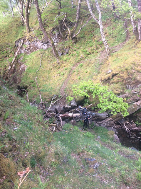
whitestoneFree MemberPosted 6 years ago@bugeye First half is straightforward apart from the cow sh!t bog just before you get out of the woods (unless it’s been drained). At the point where it heads south to Loch Maree it starts to get interesting. The track (word used advisedly) along the loch shore is the above mentioned Postman’s path which is used on the HT550
Here’s one bit where I had a sense of humour failure – the gully
The tree has now gone but there’s a 1.5m high boulder choke to climb.
Here’s Ian’s Barrington’s report on it from last year’s HT550
bugeyeFree MemberPosted 6 years agoCheers Whitestone. I thought they might be the same trails but wasn’t 100% on which bits were bad. Glad I checked now 🙂
CheezpleezFull MemberPosted 6 years agoThere was a decomposing deer in amongst the tree in the gully when I did the Postie Path a dew years back. Added enormously to the fun 😯
The Tollie Path was good for the views but the riding wasn’t all that great, as I remember it.
FOGFull MemberPosted 6 years agoThere are some other nice out and back tracks in the area.Up from the B8056 through the Shielding forest to Loch a Bhealaich which includes a rather sketchy bridge crossing, from Aultbea up to Loch na Moine Buige.
Can you join this to the Little Gruinard River track? Last time I was up there I was in a hurry so went back the same way. I have to agree about Tolly track, not a particularly enjoyable experience but a beautiful area that feels as remote as anywhere.felltopFull MemberPosted 6 years agoFOG – yes, the track from Aultbea (from up behind the Drumchork Hotel) can readily be linked yup with the vehicle track high above the south side of the Little Gruinard River, known locally as Kenny D’s road. There’s about 0.5km of pushing over boggy ground to link them. BTW, I prefer to do it the other way round.
fadgadgetFree MemberPosted 6 years agoSlattadale /Tollie path includes a fair bit of roadwork TBH especially heading uphill from Gairloch. The Tollie path itself is now a watery rocky mess in places especially lower down. The woodland sections on the approach to Gairloch are pleasant rather than exciting but it’s still worth doing as it’s in a great area.
fadgadgetFree MemberPosted 6 years agoSlattadale /Tollie path includes a fair bit of roadwork TBH especially heading uphill from Gairloch. The Tollie path itself is now a watery rocky mess in places especially lower down. The woodland sections on the approach to Gairloch are pleasant rather than exciting but it’s still worth doing as it’s in a great area . a decent warm up or warm down if doing the bigger Fisherfield or Torridon routes.
whitestoneFree MemberPosted 6 years agoAnother question from me about other tracks in the area.
There’s a track on the South/west side of the Gruinard river up to the outflow of Loch na Sealga. There’s also a path/track marked on the map looping round the other side of the river and back to the opposite bank of the river. Is it possible to make a loop of this? Is the river even fordable?
slowmogirlFree MemberPosted 6 years agoWhitestone-we tried this a few years back to make a loop, the trail on the other side doesn’t seem to exist, certainly no sign of it leading away from the loch. The outflow was also about waist deep in summer.
felltopFull MemberPosted 6 years agoWhitestone – the track on the north side does exist further up the hill, but as slowmogirl days, the outflow from Loch na Sealga is very deep.


The topic ‘Scottish Highlands – Poolewe’ is closed to new replies.