- This topic has 13 replies, 5 voices, and was last updated 13 years ago by Scienceofficer.
-
Mendips riding – connecting Sandford / Strawberry line area with Bleadon Hill?
-
agentdagnamitFree MemberPosted 13 years ago
Always looking to avoid road sections on Mendips rides…
Is there riding to be had west of the Strawberry Line to get to Bleadon Hill for the descent to Loxton? the OS Maps make it look like there might be some stuff near Banwell Castle and Banwell Hill, but I didnt really find anything last time I had a quick look.
I usually ride east of the A38, but like Crook Peak and some of the descents there, but harder to build into a flowing ride avoiding road I reckon?
oldfartFull MemberPosted 13 years agobeen a while since i did it but if you head towards banwell there is a bridge you go over that connects you up with the b/way descent you mention.hope that helps .
ScienceofficerFree MemberPosted 13 years agoDepends where you are on the Strawberry line. Its not worth the effort for that descent IMO.
buzz-lightyearFree MemberPosted 13 years agoThere is an old byway going NW from the Winscombe cemetery off the strawberry line. It joins the Sandford/Banwell road about halfway between. It’s not great.
When you get to Banwell, if you take the turning by the castle and take the next right, then look for a gate on your right with a sign saying “no cycling”. Cycle west along this wide track (actually an FP) 😳 until it descends to a little lane, turn left and then right to pass over the M5 on a bridge. Continue straight on, on the bridleway. Watch out for the vast wheel swallowing puddle! After the puddle turn left and climb to the cottage, turn right and climb, then left and immediately left. You are at the top of the bridleway that descends to Loxton.
The descent of Loxton hill is a bit rubbish in the main – shallow, wide, 2xgates. I think it’s actually better to do all this in reverse.
agentdagnamitFree MemberPosted 13 years agoCheers guys. Buzz – about a year ago that BW you mention was closed at its north end, presumably by the landowner… Never ridden it, but doesnt sound great.
I’ve never actually done the Loxton Hill climb as a descent either, just fancied it after climbing it several times, but you dont notice gates so much on the way up.
Very muddy around Crook Peak yesterday, not surprising really.
buzz-lightyearFree MemberPosted 13 years ago“that BW you mention was closed at its north end,”
The byway? I rode it 3/4 weekends ago and you’re right, the gate at the end is locked. There was a chap using a digger the field next to it and he watched us lift our bikes over without comment. I expect he blocked it to stop people razzing their 4×4’s past his farm. There is a gate on the next field along so I wondered if he had simply diverted the RoW. Just carry on using it IMO.
BTW. I noticed there is a gate/track by the road leading into the wood that backs onto Banwell castle. The OS map show some tracks looping around in there. It warrants surreptitious exploration methinks.
ScienceofficerFree MemberPosted 13 years agoThe few tracks I’ve made the effort to explore in that direction don’t seem to be worth it. I think they suffer from being a bit too close to populated areas and farms to be anything decent.
TBH I only use Bleadon Hill/Loxton Hill, to make a circuit from my house when we’re riding out from home. Its a good way to get to/from Weston promenade and then Weston Woods, which allows us to put some spinning miles on the route.
IME good, contiguous riding starts at Winscombe/Sandford/Crook Peak, so really, the strawberry line acts as a kind of notional Western boundary of half decent Mendip riding, with Crook Peak as the single notable outlier to that.
agentdagnamitFree MemberPosted 13 years agoOK, so Crook Peak experts, what climbs and descents do you use?
We usually park at Kingwoods and climb straight up the rooty broad climb then either on to Wavering Down or contour around to the left, then up to Crook Peak.
I found what I presume is Slot Cars last year, running down from the Vets at Hill Farm down the lower west side of the broad ridge to Cross.
There’s the obvious bridleway off the summit NE then W then has the nice rock garden half way down. I’ve tried to NW off the summit to join this, but never found much.
SE off the summit is pretty dull, if grassy and flat. Small rocky area towards the end, but doesnt make up for the remainder of that trail for me. Never climbed up this way.
Done the climb up W of Compton Bishop, the one that gets loose and steep at the top. Seems a pretty good way to get back up on the hill. Never tried the trail that passes Combe Cottage on the OS map.
Found some decent singletrack south of Kingsword and near Webbington, but never tried anything north of the East to West axis of the hill. I know it would probably be cheeky, but is there anything running down to the Barton road?
Rainy days were made for virtually trail exploration, tea in hand….
ScienceofficerFree MemberPosted 13 years agoThere are some cheek trails running West-East on the Southern flank, one of which would be ‘heart bypass’, the other is a little something that Buzz and I found. In these conditions I think it’d be quite challenging.
I’m not prepared to put the directions into public domain, but it sounds like you know the area quite well. Take what you know as a framework and start filling the gaps, and follow your nose.
😉
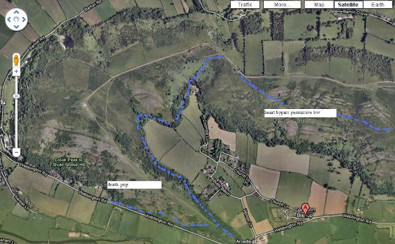
nickeggFree MemberPosted 13 years agoNothing cheeky about ‘Hearts Bypass’ or ‘Slot cars’. Both are National Trust bridleways but therefore not marked on OS maps as they’re permissive.
buzz-lightyearFree MemberPosted 13 years agoI’ve been very gently warned off the grassy descent south west from Crooks Peak by a warden. A pity because it ain’t boring if you death grip it – you can’t avoid getting airborne in places. And it’s generally open enough to avoid a high speed collision.

I’ve marked my preferred descent route. There is a short steep climb in the middle.
Anyone followed Barton Drove?
ScienceofficerFree MemberPosted 13 years agoWhat on earth is a ‘National trust BW’? This is something I’ve not heard of before.
Is it some quasi-legal thing? Do you just mean its permissive? If you do, I don’t see why its not marked on the OS. Plenty of other permissive BW’s are.
buzz-lightyearFree MemberPosted 13 years agoYes it’s permissive. There are some permissive FPs around there to. But I wouldn’t know about that.
The topic ‘Mendips riding – connecting Sandford / Strawberry line area with Bleadon Hill?’ is closed to new replies.