Viewing 19 posts - 1 through 19 (of 19 total)
  • Local trail exploration – Strava Heatmap
  • nedrapier
    Full Member

    Just print-screened a dozen or so tiles of the area round here, cropped to get rid of menubars etc, stitched the lot together, geocoded and converted to custom map – now on the garmin, off out after some food to see what the good stuff looks like!

    😀

    r8jimbob88
    Free Member

    I’ve wondered if it was possible to do that. I wonder no more!

    nedrapier
    Full Member

    yup! Been thinking about it for a bit, sat myself down to do it.

    I used

    1) more time than I thought
    2) chrome, f11 for full screen for biggest screen grabs
    3) plenty of overlap because ICE wouldn’t stitch with only .5cm ish
    4) Microsoft ICE for stitching
    5) QGIS georeferencer and Google Maps right click and “what’s here?” to grab co-ordinates – Google maps uses EPSG:3875 CRS (QGIS need to know)
    6) OKMap – Load Geotif created in QGIS, “Map Tiling” from the “Utilities” menu, tiles less than 1000×1000, generate, save kmz file onto Garmin.

    scaredypants
    Full Member

    7) WTF? – please can you put points 3-6 into english ?

    actually, don’t bother – I’ll never get round to that 🙁

    nedrapier
    Full Member

    Sorry, that was almost pointlessly quick, I was imagining people clicking on this who might know a bit about was involved already – quite a few map geeks on here, I’ve noticed!

    Microsoft ICE is a free to download photo stitching programme – works very well with panoramas, but is perfect for this too. So easy to use, it’s not worth explaining! Import your cropped screenprints into here, export one big jpeg.

    QGIS is a free to download mapping programme. Using the georeferencing tool -pick a point (e.g. road junction) on the jpeg, and input the long/lat you get for the same point in google maps (right click on that point “what’s here?” will give the the co-ords.

    Now you’ve got image file (geotif format) that is georeferenced and can be overlaid on a map. But if your garmin supports custom maps, they need to be in kmz format, and divided into “tiles” (individual images) that are less than 1000 x 1000 pixels.

    OKMap is another free to download mapping programme that will do this (it will georeference too, but I started with QGIS first, so didn’t want to learn another programme). Load the tif that you generated in QGIS, find “Map Tiling” in the “Utilities” menu, save the kmz file onto your laptop, or straight into the Custom Maps file in your Garmin.

    Have a glass of wine.

    nedrapier
    Full Member

    [video]https://www.youtube.com/watch?v=Cb_qrNh_6_Q[/video]

    [video]https://www.youtube.com/watch?v=SCYFM2ceK18[/video]

    paulrockliffe
    Free Member

    Wow! Thanks I’ve been meaning to plot some heatmap stuff onto Memory Map so I could navigate some new trails, but this is so much better!

    Are you able to have the garmin follow the trails, so it beeps at you if you’ve gone wrong, or is it just lines on the screen.

    Awesome!

    nedrapier
    Full Member

    nope. just lines on the screen. That’s how I use my garmin most of the time anyway. Inspiration for this was heading to Surrey hills with gee’s 100 miler as a track and using that as a pointer for trails I might not know about.

    paulrockliffe
    Free Member

    OK, cool, that’s what I do anyway. Do you know a clever way of creating a course from the Strava data?

    nedrapier
    Full Member

    Nope, sorry! Not sure how that could work, either. The heat map is just a overlay of all the user recorded track points. There’s nothing in that information saying which direction people were headed when that point was recorded. More recorded points in one place = brighter colour. Nothing saying where they started, where they were going to, or even where they were going along along the trail or across it.

    You can use it as a way of plotting your own routes, but then you need to check the contours and the shape of the trails and figure out which are the climbs and which are the descents. Easier to head out for a follow your nose ride, but with this in front of you as a clue that that rabbit track isn’t a popular trail.

    You’ll obviously miss out on some nuggets and proper secrets, but I reckon it’s going to be a nice way of getting to know some of the good stuff in an area.

    jam-bo
    Full Member

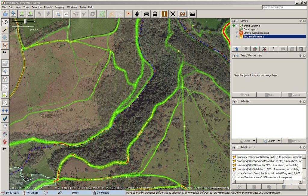
    I think from some quick googling you can pull strava heat map into openstreetmap for route tracing.

    When I stayed near Ambleside recently. I looked at the top 10 leaderboards for the close DH segments, then looked at the rides they did and downloaded/followed the GPX. Seemed to work out pretty well.

    nedrapier
    Full Member

    Yup, if you want a route to follow, that’s definitely a better way. Especially if you’re not in an area long, and just want one or two nice rides.

    markshires
    Free Member

    You can use the route planner in strava and have the heat map and segments overlayed on the map, to plan routes now.

    jam-bo
    Full Member

    so, the strava heatmap is pretty easy to access with JOSM, just got to work out how to get a OS 25k overlay in there as well…

    nedrapier
    Full Member

    Nice. Not seen JOSM. Is it a good tool for route planning? I’ve had a couple of goes with basecamp, used bikehike a fair bit for short routes and amending others.

    jam-bo
    Full Member

    no idea, first time i’ve played with it but the strava heatmap is available as a WMS TMS layer so should be able to be imported directly into most GIS clients.

    nedrapier
    Full Member

    arg. my turn to be flummoxed by map stuff. 🙂 back to google…

    Cheers!

    jam-bo
    Full Member

    Tiles of heatmap data served up on request. so automating stages 1-5 above.

    nedrapier
    Full Member

    When you say “on request” that’s on a screenview by screenview basis, rather than eg downloading UK OSM cycle maps?

Viewing 19 posts - 1 through 19 (of 19 total)

The topic ‘Local trail exploration – Strava Heatmap’ is closed to new replies.