[img] 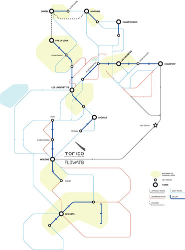 [/img]
[url= http://www.flickr.com/photos/guybowden/4460728580/sizes/o/ ]big version here[/url]
Have been working on it for a couple of days - what do people who've been to the PdS / Morzine think? what about those that haven't?
Bare in mind that things might not be spelled correctly - and the lines with no arrows on are waiting for me to add the arrows!
cheers!
rubbish.
it's a mountain range, not a city
speak your mind 🙂 I can take it.
I'm afraid I've never been to Morzine, but I do think this is a really good idea, taking an iconic design somewhere new. I don't know if it would be practical or not. Well done, see where it goes.
It's good. The addition of valley bottom and ridge lines would be useful to, it's rather easy to find yourself on the wrong side of a ridge we found 😳
[b]/edit[/b]; plus elevations on major points. and pubs (ofc)
The addition of valley bottom and ridge lines
was thinking that - how to add that without making it more confusing is the trouble!
And GW - it's only really meant to show connections between the lifts / towns. Not really the detail of the trails.. there's proper maps for that.
I prefer the ski map style. You get a better idea of haw far stuff is and how much up there might be. More of an issue on a bike than on the tube. I don't think its complicated enough to need simplifying. Maybe you could put height gained/lost and distance on the routes
Nice idea - but not very useful for me, sorry.
Doesn't show distance, height gain or loss, or ground - so hard to work out what goes where (I know this isn't a trail map - but these would help for reference points). Also this means it's no good for working out whether to take lifts or the links, so little actual pracitical use either.
Clearer than the usual maps for showing how things link up, but really hard to get your head around - especially of you don't know the names of the things. Lack of distances don't help here either. Labelled runs might improve things.
Ridges/other features - shapes of towns etc would help me - but then it's turning into a map, rather than something to show the links. Could you try overlaying your 'tube' map on an actual map/pictoral map of the area somehow
Great idea, maybe needs a little 'tuning'.
I thought it was forbiden to build new metro network in France...
Oh hang on I got it now, that's for the tramway right...
Cheers for the feedback.
The question of links or lifts is perhaps answered with the fact that apart from a couple of exceptions the trails go down hill, the lifts go up hill. On this map it's only the col du cou which is really uphill - other trails have slight inclines, but can all be done on a DH bike no probs. The uphill trails can be notated differently perhaps - linestyle / colour.
It'll be restricted to signed / official bike routes only as well - (some on here aren't - so need removing!)
I guess I meant it to be an easy way to answer: "What's the easiest way from Morzine to Morgins?" or "Can I get back from Linderettes to Morzine when the lifts are shut without climbing?"
Thats confusing for me (and I know the area roughly!)
On a side note- they were doing some "road" construction on the hillside above the bottom of the Pleny lift when we were out last year (the end of the off road return from Les Gets route)- is it a new road?
PS. sounds like a cracking idea with your partnership with Torico- will visit this year!
is it a new road?
nope - upgrading the piste - downgrading the singletrack 🙁 - installing snow cannons.
see you in the shop mate - come and buy stuff 🙂
I'd have found something like that very useful when I was there a couple of years ago (assuming it's accurate!)
I like it 🙂 How about putting the last lift times on there also (if they are reasonably fixed).
assuming it's accurate
it's accurate to a point - but it's certainly not to scale!
It's good. The addition of valley bottom and ridge lines would be useful
add some shading for high ground/low ground. needn't be much, the brain's good at spotting patterns
the key is good but i found it hard to notice the colour difference for the bike park. possibly a black outline around it may help.
I'd also add the Swiss/French border, as well as naming places like Lac Vert, Lac Montriond and some of the refuges. Is it worth marking on the PPS route + variations also? assuming it doesn't vary from year to year too much.
So basically it's like a map but worst. why don't you do as mentioned above, something a bit more realistic.
why bother
[url=  ]when its been done already! [/url]
That one in bruneep's link is the one I use and like. Its easy to read and has loads more info then the tube map style.
yeah - that skimap style one is alright - just having a go at something new.
it is like a map but worse Juan (and others) - in that it doesn't have all the contours / extra features of a proper map, the aim wasn't to replace the IGN map, but to try something different. Just a simple idea that's all.
its like the route planner at the front of your road map. I go here, then here, then here - simple... that was the idea anyway..
cheers for all the feedback.
Nice idea, and works quite well for the ski lifts, but it gives the idea there is only one or two trails to try to get from one lift to another (which there isn't - there are loads).
only one or two trails to try to get from one lift to another (which there isn't - there are loads).
true - but there's an IGN map for every possible trail from A to B - I've also not added in any DH trails as there are far too many to put down in something like this - hence the yellow blobs!
And GW - it's only really meant to show connections between the lifts / towns. Not really the detail of the trails..
I realised that. that's why it's rubbish.
