- This topic has 46 replies, 8 voices, and was last updated 11 years ago by offthebrakes.
-
Guildford to Farnborough off-road
-
jambalayaFree MemberPosted 11 years ago
Definitely you could work something out.
I used to ride to/from Guildford/Normandy to pick-up/drop off the car for servicing.
Across Shalford Park and over river there onto NDW (I used to climb up the small side road behind Police College). If you come out of the town centre you can just ride up the road past Henley Fort to the radio masts at top of hill or link along the towpath to Shalford footbridge.
Getting across the Hogs Back was a bit messy but I used to drop down towards Wood Street/across the railway. Footpaths (rarely used) / bridleways / farm roads / ..
You can stay on south side of Hogs Back till Puttenham (bridge over A3) then road/boat to Ash.
I am sure you can get over Pirbright Common / Tunnel Hill to Farnborough perhaps with a trail or two – all a bit sensitive there though these days.
jambalayaFree MemberPosted 11 years agoSuggest you nudge @piha – I am sure he’ll have a much better idea than I. Some of my route was a bit rough (eg Bridleway down to Wood St was just a track across a field) but there are plenty of quite roads/farm track alternatives.
molgripsFree MemberPosted 11 years agoHmm.. If it’s possible to ride over the ranges that would help a lot.. I think it might be but I’m always scared of being blown up.
theotherjonvFull MemberPosted 11 years agoYou can skirt the ranges offroad even when the flags are up. it’s only the Ash complex that is really in the way.
I’ve got to leave for an evening mtg but will make a suggestion later or in the am. Where in GF to where in farnborough?
molgripsFree MemberPosted 11 years agoCentral Fboro to eastern Guildford just north of the A31. Holiday Inn Express in fact.
Google maps sends you through the area near the ranges from the Tunnel Hill road (Mytchett-Pirbright) WSW to the A324. That’d be nice if it’s open.
jambalayaFree MemberPosted 11 years agoGuildford end I assume you mean the Uni sportfield/Research Park. Looks like it’s easy to take a cheeky cut through to Wood Street, even if you go round the range toward Pirbright it’s a short diversion really. Quiet Roads/Bridleway/small cheeky sections
molgripsFree MemberPosted 11 years agoBTW I meant ESE not WSW in my previous post!
Yeah looks like heading north to Pirbright Lodge and then NW on that bway to the road then I could filter through the whole of the Tunnel Hill riding area, ridden a bit there before.
Yes, near the Research park. Looks like the cheeky trail would be the uncontested kind.
pihaFree MemberPosted 11 years agoFor an extended route you could try this = http://www.endomondo.com/workouts/ . You might need to fine tune things a bit depending where in Farnborough you are. This was the route I took when I went from 12;12 TORQ in your sleep in Minley back to Guildford.
Alternatively you could get on the Blackwater Valley Route around Farnborough North Station and make your way to the Basingstoke Canal (plenty of places to get off the canal to play on the singletrack). Get off the canal at Dawney Hill and follow the trail/footpath/bridleway/byway through Pirbright Common to Fox Corner. Bit or road (past the Christmas Bakery) and a left on a footpath on Rickford Common then Jordan Hill and Whitmoor Common and Mount Pleasant. Then drop into Guildford on the road.
molgripsFree MemberPosted 11 years agoThat workouts link isn’t working… interesting idea going east then south though. Loads of options it seems.
loumFree MemberPosted 11 years agoop,
I find bikeroutetoaster.com loads more useful than google maps for sorting new routes on a bike.
Just do start and end points and get your settings right for bikes, osm, etc.
Then play about with the calculated route to make it a little more interesting.PeterPoddyFree MemberPosted 11 years agoGetting across the Hogs Back was a bit messy
Don’t bother! Start at the other side (i.e. ride through town towards the retail park, Halfords, B&Q etc) of the Hogs Back there’s a foot/cycle bridge that crosses the dual carriageway, past the Kawasaki dealers, straight on up the hill, past the Co-Op, left at the roundabout (Wood Street Village?)
I’ve done it a few times, leisure riding, and half of it I’ve been cycling regularly for 8-10 years!
Basically, there’s some lanes and byways from the back of Wood Street Village (I think…) towards Tongham. You’ll need to get an OS map for those though, but they’re easy to find and navigate…
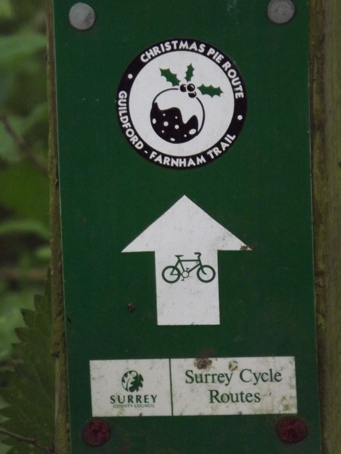
Once in Tongham (Enter Tongham on the old railway line) you can pick up the Blackwater Valley path (Down the side of the Cricketers Pub, under bridge, turn immediate right) which roughly follows the A331, jump off at North Camp, over the foot/cycle bridge, up to Farnborough Road and then it’s shared path into town. I reckon the first half of the route is 40% traffic free, the second half from Tongham 90% traffic free. Nothing technical, just nice quiet lanes and paths.PeterPoddyFree MemberPosted 11 years agoAhh. My route follows a marked path IIRC. Can’t remember the name though… Goes through the village with the best name in the UK – Christmas Pie!
pihaFree MemberPosted 11 years agoHmmm, sorry about that link, try this one instead ….http://app.strava.com/rides/19877736.
You could hook up with the route (if the link works) from Ively Road. Loads of route options in Beaconhill Copse for a play and the majority of the route doesn’t suffer too much in wet weather.
PeterPoddyFree MemberPosted 11 years agoHere it is
http://www.puttenhamcampingbarn.co.uk/docs/christmas_pie_leaflet_scan.pdf
North of the Hogs Back, the Christmas Pie route into Tongham
pihaFree MemberPosted 11 years agoGrrr – still didn’t work!
Last attempt – http://www.endomondo.com/workouts/lS9X45wRLBE
PeterPoddyFree MemberPosted 11 years agopiha, nice ride, but that’s going waaaaaaaay out of his way for a commute! 🙂
allthepiesFree MemberPosted 11 years agoChristmaspie trail + 1
Offroad all the way from Guildford (Park Barn 😯 ) to Wanborough, then through to Tongham outskirts on byway, old railway line to Tongham then Blackwater Valley Path to North Camp Station.
PeterPoddyFree MemberPosted 11 years agoPies, yeah, that’s about it, although you seemed to stick to the roads between Guildford and Tongham? There’s a few nice pleasant bridleways down there too. Did you use those?
allthepiesFree MemberPosted 11 years agoThat’s not actually my track recording, I found it on t’internet and it does use the Christmaspie trail rather than roads between Guildford/Tongham. I’ve ridden the same route loads of times and it’s a great way of getting to/from G’ford.
I got the tracklog from here:-
jambalayaFree MemberPosted 11 years agoTongham – home to the Hogs Back Brewery, very fine beers indeed (tours available !)
Christmasspie – agreed a most excellent place name (even if a bit non-descript in reality)
molgripsFree MemberPosted 11 years agoRight, excellent info folks. Last night I just cut through the range on the trail I mentioned earlier because it was getting dark, and I came back the same way to get to my 9am meeting. Took 50 mins or so without breakfast 🙂
There are plenty of options. I like the Christmaspie route – is it waymarked? It let me download a KML from atp’s link, so I’ll try and force that into my Garmin. I’m also tempted if I have time on an evening to go via Tunnel Hill, ride around the singletrack aimlessly for a bit then come back either via phia’s route or just through the range again.
I didn’t get shot, but it wasn’t clear if I was disobeying the rules as the flags were flying but I didn’t actually pass the ‘don’t come in if the flags are flying’ sign.
Actually piha’s other route to the west of the airfield could be fun – nice long trip, but I haven’t got sufficient lights currently so it might be an issue.
theotherjonvFull MemberPosted 11 years agoAbsolutely definitely don’t go in if the flags are flying, even if you don’t pass a sign, and if there’s no evidence of shooting. To be seen / picked up in that circumstance would do the work TAG are dooing with the military over responsible access no benefit at all.
My route from Guildford would be.
From HIE, out through Park Barn and up Rydes Hill Road (streetmap it) to pick up bridleway over Chitty’s common to Pitch Place (here)
N on the road for a tiny bit, then rt into salt Box lane and then left up the cheeky footpath over Whitmoor Common, pick your own route but you want to end up at Fox Corner here
Don’t worry about using the main road for the last bit, there’s a cycle path past the bakery.
Go NW on the byway as far as the road, but then skirt L-R-L around the green as that last bit of BW is a bog.
N up the A road, but look out on the right for the War Graves (worth a visit anyway, as is the Cemetery – again google it; interesting) Go up towards the War Graves and on the LHS you pick up a path that parallels the road as far as the railway bridge and canal. Go under the RW and then W on the canal. Look to cross the canal shortly – there’s a great piece of ST over the other side (admittedly better in the other direction)
You could follow this as far as Deepcut bridge – the North side of the canal has a nice ST trail that runs the length, and then towpath on the south side thereafter to the Canal Ctr which is a short hop to farnborough. Or, at Curzon Bridges (here: http://www.streetmap.co.uk/map.srf?x=496246&y=154815&z=115&sv=496246,154815&st=4&ar=y&mapp=map.srf&searchp=ids.srf&dn=631&ax=496246&ay=154815&lm=0) you can cross the canal and railway and get onto Tunnel Hill at the NE corner here http://www.streetmap.co.uk/map.srf?x=496246&y=154815&z=115&sv=496246,154815&st=4&ar=y&mapp=map.srf&searchp=ids.srf&dn=631&ax=496246&ay=154815&lm=0 and then fill your boots on singletrack to the canal Ctr.
allthepiesFree MemberPosted 11 years ago+1 to jonv. Riding over the ranges when the red flags are up is a big no-no.
molgripsFree MemberPosted 11 years agoAbsolutely definitely don’t go in if the flags are flying, even if you don’t pass a sign, and if there’s no evidence of shooting. To be seen / picked up in that circumstance would do the work TAG are dooing with the military over responsible access no benefit at all.
Alright, well how am I supposed to know if there’s no sign? All I saw was a sign saying stick to the road. The flags were on side roads anyway so it wasn’t clear if they referred to those side roads.
theotherjonvFull MemberPosted 11 years agowhere did you go in then? The area is fenced and all entrances gated with notices as far as I remember.
{edit} having reread your earlier message, if you went NW on the b/way from Pirbright lodge, it’s a pretty obvious gate with a flag where that comes out, and the b/way stays to the east just outside the perimeter of the danger area. So that’s fair game even if the flags are up, as long as you’re outside the fence. Once at the shooting end of Stoney Castle range, go left on the road for about 400m and then as the hill starts to level off theres a little turn in with a concrete block on it – turn in here, carry straight on that path and you’ll hit TH
there are some decent trails on Ash ranges but it’s hit and miss whether they’ll be firing (see what i did there) so i never base a ride on those trails, just do them occasionally if they’re free.
The perimeter road just inside the fence is a useful 7 mile round blast with a couple of sharp hills for a training blat.
molgripsFree MemberPosted 11 years agoFrom here
to here
Pretty sure this morning at the Guildford end there was no sign despite the flags. It looked like the signs were for the other directions. Could be a signage f-up of course. Also it could be I was not looking in the right places and h ve missed something.
theotherjonvFull MemberPosted 11 years agoHmmm, I’d figure a misinterpretation there. Cos i sure as hell wouldn’t ride that path when the flags are up.
molgripsFree MemberPosted 11 years agoI’ll try the Pirbright lodge bit tonight. I have insufficient maps for the Christmaspie route (may look for some later although where’s going to be open? Garage maybe?) and I’m more familiar with TH.
Am I right in thinking I can use this cheeky footpath to get to Pirbright Lodge?
allthepiesFree MemberPosted 11 years agoIf you took the direct route between those points i.e. straight over the ranges than you were in the firing zone. They don’t put up and take down signage, just the flags. The whole area marked Danger Area is the fenced off range with the flagpoles dotted around the perimeter.
Perhaps you went around the perimeter outside of the fence ?
molgripsFree MemberPosted 11 years agoThey don’t put up and take down signage, just the flags
I saw the flags, I didn’t see any signs posted *on that route* telling me not to go there when there were flags, just telling me to stay on the road.
There were other signs facing away from me.
PeterPoddyFree MemberPosted 11 years agoThere are plenty of options. I like the Christmaspie route – is it waymarked?
I know at least some of it is, but what the markings say exactly I can’t say…. :o)
molgripsFree MemberPosted 11 years agoLol.. well I’ll do it maybe tomorrow but with a map, if I can sort one out.
allthepiesFree MemberPosted 11 years agoThe Christmaspie signs feature a small round christmas pud image 🙂
 theotherjonvFull MemberPosted 11 years ago
Am I right in thinking I can use this cheeky footpath to get to Pirbright Lodge?
Yes, that’ll actually be the perimeter road around the ranges. IIRC the footpath is just outside the fence at the start with the perimeter road inside, and then the perimeter road switches to be outside as well (so fair game) just after the Henley Park range control building.
molgripsFree MemberPosted 11 years agoOk, I’ll try the Christmaspie route tomorrow morning then.
Things I learned today:
1) The woods around Pirbright Lodge are a maze of big wide tracks and
2) The man who works at the post office in Wood St Village is not very nice!
molgripsFree MemberPosted 11 years agoI wheeled my bike half into the doorway so I could ask him if he had any maps.
He kept telling me not to bring my bike into the shop and would not even listen to me for a moment, even as I was turning to leave. If there’s one thing I can’t stand it’s not being allowed to speak! GRRR!!
The topic ‘Guildford to Farnborough off-road’ is closed to new replies.