I've got the day to myself tomorrow, so thought I might head to the peaks. Can anyone recommend me a nice route that shows off the best bits. 20 - 25 miles maybe?
No looking for an epic, more just some fun. Don't mind techy descents, but would prefer to gain the altitude as easily as possible...
Hollins Cross looks the most obvious on the OS maps. Climb up Mam Tor? Which way down? What about the Ladybower Loop or am I in the wrong area? Where is the best base? I wouldn't mind a nosey round 18bikes whilst I'm over that way...
Sorry 101 questions. Cheers
20 - 25 Peak miles is a good old ride. Park in Hope. Go up to Edale Cross. Straight over to A57. Lockerbrook. Fairholmes. Whinstone Lee Tor. Yorkshire Bridge. Edale Cross. Jaggers Clough. Edale. Hollins Cross. Mam Tor. Perry Foot. Pindale. Hope. 18 Bikes. All ridebale up and down apart from 18 Bikes. You'll have to get off and walk there.
Or if you're planning on coming back, pop into 18 Bikes in Hope and invest in a copy of the Vertebrate Publishing Dark Peak guide maybe?
[s]edale cross[/s] - he means HOPE cross
Yup, 25 miles in the Peaks is pretty solid!
So many options really, why not start in 18bikes, get some route advice and end there for a giant Yorkshire, bangers and mash from the Courtyard caf.
That's the one! All these crosses(sic) look the same....like crosses 🙂
1. Start in Hope.
2. Up Pindale, down Cavedale to Castleton.
3. From Castleton go up the old b road to Mam Tor, round the back and over to Hollins Cross, and down to Backtor Farm.
4. Then to Nether Booth and follow the bridleway to Jagger's Clough and across to Hope Cross, straight across at the cross roads and down the steep descent to Haggwater Bridge (aka 'The Beast').
5. Turn left at the bottom of the beast, cross the A57 and go up Hagg Farm bridleway (if you turn left at the A57 and follow it for about a mile there's an easier climb up via Rowlee Farm).
6. At top, follow bridleway past Lockerbrook Outdoor Centre all the way down to the road next to Upper Derwent Resevoir.
7. Turn right at the bottom, go to fairholmes for crap instant coffee and food stop.
8. Across the dam, turn right and follow road to bridleway which takes you up to Whinstone Lee Tor.
9. At top of Whinstone Lee tor follow bridleway to Cutthroat Bridge and down to Ladybower Inn.
10. If tired, follow road back to Hope. If not, follow bridleway from Crookhill Fm up Crook Hill.
11. Go down Hagg Farm back to A57 and back along to bottom of the beast you came down earlier.
12. Don't go up the beast, but carry straight on along the side of the reservoir, and take the track which forks up to the right after about a kilometre.
13. At the top, turn right and go up over the hill back to Wooler Knoll.
14. descend down to Harrop Farm then back to Hope.
Hope this helps. A map would obviously be better but I don't have one to hand. Enjoy.
Fabulous riding there, I love it.
@pook is a guru on the area organizer of peak pootles
25 miles in the Peaks means lots of climbing so that's a very solid ride (I think the loop below is less than 20 and would take me 5-6 hours)
Hope Bikes sells good guides of the area (Dark Peak) plus loops shown on maps in the shop.
From @pook I got a few routes but one good un was
Eadale (large car paid park - National Trust cafe) to Hollins Cross, Mam Tor, pickup Limestone Way to take in Cavedale descent to Castleton, climb landslipped road back under Mam Tor to Rushup Edge, Roych Clough/South Head on Pennine Way, climb to top of Jacob Ladder, great rocky descent over all too quickly (don't miss bridleway and take paved footpath = booring) and back to car
If you email me (in profile) I can send you a map
Ladybower a few options available which take in "The Beast" descent plus the obligatory photo stop at the National Trust sign at Winstone Lee Tor
Are you wanting to ride on your own? I'm hoping to get out, but don't know the area at all -
http://singletrackworld.com/forum/topic/anyone-riding-the-peaks-tomorrow-saturday
I'm keen for a decent ride but not sure if I fancy 25miles..
Have you got the VGraphics guide book for the area? Its very good to get started and for routes/to follow.
I'll be riding tomorrow but because I have to be back before 12 I'll be off early early so say hi if you see me 🙂
I did 27 miles in the Peaks last Sept - garmin reports 5000 feet of climbing!
Wow - thanks everyone, I've got an OS Map and had found pretty much all of those, so the advice around which to go up and which to go down is very useful. Cheers
Duane - I'm a grumpy bugger, you don't want to ride with me! :-). No seriously, I'm not sure of timings etc. yet and still a small [and receding] chance that I may have to work so I couldn't give you a time I'm afraid. Might see you out and about though...
Gratuitous Peaks Photos & bike love 😀
Hollins Cross
[img] 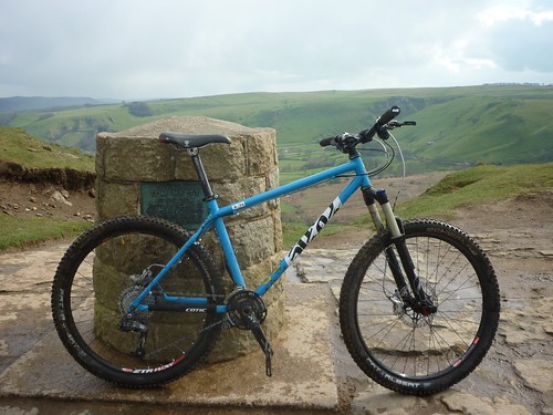 [/img]
Roych Clough
[img] 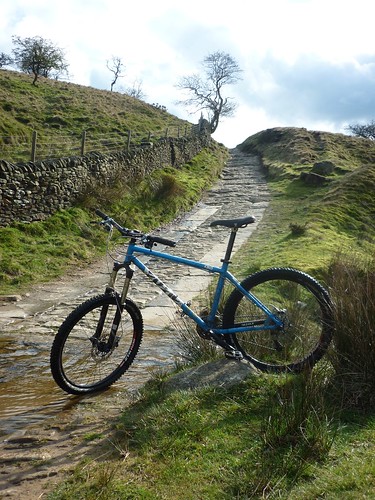 [/img]
Winstone Lee Tor & Ladybower
[img]  [/img]
Below Mam Tor on Landslipped Road
[img] 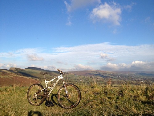 [/img]
