- This topic has 40 replies, 23 voices, and was last updated 8 years ago by budgierider67.
-
Garmin or (other) GPS device?
-
horaFree MemberPosted 8 years ago
Any recommendations? One which comes preloaded(?) with UK maps, easy to follow/download gpx files and securely barmount
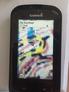
mikewsmithFree MemberPosted 8 years agoThe garmin 810/1000 series can have maps, comes on an sd card. Mounts are variable, the standard rubber band ones are good for long stems and roadie bars, the secure mounted bar fly type ones are better for mtb use.
Copy course over via usb or bluetooth, switch on select then follow route.RoterSternFree MemberPosted 8 years agoI’m still using a Garmin 800 and very happy with it. Mine came loaded with City Navigator which has all of Europe on it but only roads or bye-ways but it’s enough for me. As said following routes is easy it makes a funny beeping sound when you go of course. One word of advice when mtbing is to switch of the rerouting option if you do go of course as it can send you in odd directions.
bobloFree MemberPosted 8 years agoHaving poo pooed them for years, I tried the free OSM maps recently and they are excellent if you get the cycling version. They show cycle paths etc and the only downside is the map can obscure the pink route line occasionally. On the Garmin maps, the width of roads doesn’t do this. Just means you need to pay attention a bit more.
I wouldn’t buy Garmin maps now and if in the market, id buy a Garmin 810. I’m not an early adopter when it comes to Garmin as they have history of selling stuff that isn’t ready and then it needing a number of updates before it’s really usable.
muddy9mtbFull MemberPosted 8 years agothe garmins okay and has a long battery life (personally I don’t along with mine as the post above)) and for the extra £50 for the full os map version is well worth it. If you can do without the dedicated cycling features you could consider the memory map adventurer http://www.sportsdirect.com/memory-map-adventurer-2800-gps-787028?colcode=78702899&src=google&gclid=CJiH4OyE-MUCFeHJtAod1BYARg&gclsrc=aw.ds which can usually be found on ebay at reasonable second hand prices.
lungeFull MemberPosted 8 years agoDepends how much you want to spend and how much functionality you need. I have a cheap Garmin 200 that uses the breadcrumb style navigation and, whilst it has the odd moment of confusion it’s fine for most uses. I just upload and design route on my PC.
I’m sure the 810/1000 are better but they’re also a lot more money.
freeagentFree MemberPosted 8 years agoGarmin edge touring here – think I paid £135ish for it from Bikediscount.de.
It has UK maps on a micro SD card, and will do everything you want.
The battery life is also fantastic (much better than using a phone)However the interface with the PC is a bit crap/clunky and feels like it is 10 years out of date.
Garmin should just get into bed with Strava..
muddy9mtbFull MemberPosted 8 years agoGarmin should just get into bed with Strava..
I think they did judging by the perfect symmetry between garmin connect screen and strava?? agreed that the garmin interface is not brill both on pc and on device, but hey that’s what you pay big bucks for 😯
DanWFree MemberPosted 8 years agoI’m still using a Garmin 800 and very happy with it.
Same here. OS maps are great and all the connectivity with other sensors you could ever wish for. The gimmicky stuff on the newer versions don’t do anything for me and I couldn’t be happier with my 800.
bobloFree MemberPosted 8 years agoI’m still using a 705 and can’t see a compelling reason to change until something stops working.
rancidFree MemberPosted 8 years agoIf you want it for maps then I recently found a Garmin Edge Touring with Full UK OS landranger maps (£199 alone) for £279.00. have a look on OS site
andyg1966Full MemberPosted 8 years agoI use a Garmin eTrex 30 with open streetmaps and think its really good. No HRM but I don’t care about that. Use maps.bing.com (OS level 1:25000 zoom for free) to create routes, export into GPX, import into Garmin Basecamp and then send to device.
Colour screen a bit small but OK for following a purple line on a MTB.
Mounts are zip tied on, the genuine garmin mounts are good, the cheap £2 ebay ones don’t latch the GPS very tight and I’d have lost the GPS if it wasn’t saved by the lanyard.
mugsys_m8Full MemberPosted 8 years agoEtrex 30 WILL do HRM andyG, and cadence I think. Basically anything ANT+
horaFree MemberPosted 8 years agoIdeally something I can load a gpx straight lngl and it reads all tracks.
Etrax10 and etrax20 look good? Itll be used for lakes routes.
proutsterFree MemberPosted 8 years agoThe best mount that I’ve found to securely hold my Edge 800 whilst on rocky, rooty trails is this one, keeps it nice and out of the way as well:
IMO you’ll be lucky to still have your Garmin on your bike if you use the supplied rubber-band type mounts and ride rocky trails fast.
It also uses the, now essential, Enduro buzzword 😉
rancidFree MemberPosted 8 years agoAndyg – how are you downloading OS maps from Bing?? I just had a look and couldn’t see any option for this? (sorry for diversion on thread)
njee20Free MemberPosted 8 years agoThe OSM maps are very good, I’ve got the OS maps for my 1000, and they’re crap in comparison! Look pretty, but too much detail to actually follow on screen, you even lose the line to follow.
The 1000 does turn by turn navigation off road, which is quite neat, used it yesterday for the first time, was impressed.
andyg1966Full MemberPosted 8 years agorancid : been away all weekend. To export GPX files from bing maps, click on my places to the left of the screen, this opens the my places editor. Create a path using the “create a path on the map tool”. Use right click to finish drawing and save. Now click on actions -> export > GPX. I have a live account so you may need to create. Hope this helps.
It takes a while to get used to the subtleties of bing maps but works very well for me.
If your stuck I’ll create a youtube video later this week.
stanfreeFree MemberPosted 8 years agoI have just bought a 810 and downloaded some maps from Talkytoaster , £12 as opposed to paying the garmin fee’s . What’s yer views are the garmin maps worth the money.?
ianfitzFree MemberPosted 8 years agoyou can also buy gamin maps on sd cards from various sellers on ioffer. around 25 quid and work just as well as the genuine article
dawsonFull MemberPosted 8 years agoNjee – could you say why?
(Just got an 800 so looking at buying more maps)
JunkyardFree MemberPosted 8 years agoworked fine for me I assume njee suspects they are not legitimate copies
I would agree they are unlikely to be anything other than real fakes, that work perfectly, at that price.
njee20Free MemberPosted 8 years agoNjee – could you say why?
(Just got an 800 so looking at buying more maps)Sure they’re genuine (well they’re not, but sure they’re the same as the pukka ones) – they’re too busy. There’s so much on the screen it’s hard to navigate with – you can’t see the routing line at all without closely staring, particularly on the road, and I don’t always want to use turn by turn.
They’re also basically copies of the paper maps, so all text is orientated north up. If you’re going south the labels are all upside down, and can obscure turnings and things, which is a minor irritation. The resolution isn’t good, you can’t zoom right in to tell where junctions are, and they’re not actually totally accurate, you often end up riding 50 foot off a road.
In comparison, the OSM maps included with the Edge 1000 have a vastly superior resolution so you can zoom right in. Around here the detail is great, although I accept that being open source if you’re in the Scottish Highlands there may not be the same detail (and the OS maps may not be so cluttered).
The OS maps look pretty, but aren’t very usable IMO.
bobloFree MemberPosted 8 years agoAs above, I use Garmin’s own and OSM. I used OSM last year for a Vietnam tour and then later for off the between track in the US. I’ve just loaded the OSM UK map onto my Garmin and its really good. They do a cycle specific one that shows bike paths and bridleways which is really helpful in my area.
The only down side is the routing line is a little bit obscured on screen by the road its routed along. You have to look a little more carefully than say with the Garmin map which has less detail. I don’t use turn by turn with my Garmin so need to follow the pink line. In town/with a cluttered screen, this can be a little bit of a faff.
I haven’t tried the OS maps on a Garmin but when I nav with paper, 1:50k is too much. There’s too much info and you cover ground on the map too quickly which means you’re forever turning/folding and often on the ‘wrong’ bit of map when you glance down. The labels often being anything other than right way up sounds a Royal PIA.
Try OSM, they’re really very good. I wouldn’t bother buying Garmin’s own now. There are moody copies on the torrent sites if you really must though I’m not advocating theft and wouldn’t bother.
njee20Free MemberPosted 8 years agoFor clarity I’ve not used Garmin’s own maps. My 705 had City Navigator, which was fine on road, but had no off road detail, and my 1000 came with OSM, which I think are excellent.
bobloFree MemberPosted 8 years ago@njee I’ve a copy of the Garmin Topo off road map for the UK. It’s shite. The OSM one is much better.
JunkyardFree MemberPosted 8 years agoI have never used mine in a town though i have on roads – Lakes though so less busy/info and found it easy enough to follow the route off or on road.
You can zoom in as much as you can with Memory Map and location was always pretty much spot on so not really an issue for me
As for orientation I never even noticed that [ as i had a route to follow] but I suspects that is correctstanfreeFree MemberPosted 8 years agoI have just bought the talkytoaster Uk map with contours and I’m hoping there good. I’m off to Glencoe tomorrow so will let you know . They seem fine for road cycling.
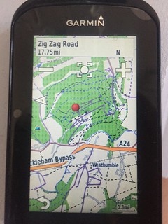
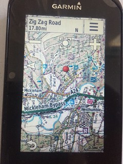
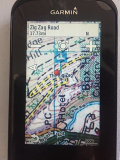
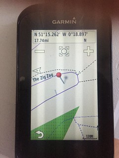
njee20Free MemberPosted 8 years agoHere’s what I mean – a few photos of my Edge 1000 taken just now, showing OSM maps and Ordnance Survey of Box Hill:
OSM, zoomed out:
 [url=https://flic.kr/p/uhEjYm]Untitled[/url] by njee20, on Flickr
OS, zoomed out (same scale) – looks very pretty!:
[url=https://flic.kr/p/uhEfe1]Untitled[/url] by njee20, on FlickrOSM, ordinary distance:
[url=https://flic.kr/p/ujZq3Z]Untitled[/url] by njee20, on FlickrOS, ordinary distance (you still get some of the Garmin/OSM labels as I’ve not disabled that map):
[url=https://flic.kr/p/ujAkE3]Untitled[/url] by njee20, on FlickrOSM, zoomed right in, useful off road when there are loads of paths:
[url=https://flic.kr/p/to9vii]Untitled[/url] by njee20, on FlickrOS, zoomed right in. Oh…. The road itself appears to be about 50 foot wide, I think:
[url=https://flic.kr/p/u3xei4]Untitled[/url] by njee20, on FlickralisonsmilesFree MemberPosted 8 years agoTake a look at the Mio Cyclo. Comes pre loaded with maps all inclusive price, cheaper than the Garmin generally. Barmount pretty much same as Garmin’s, with a cable tied option or the elastic band style attachment. I tend to move mine between bikes so use a Garmin mount. Good battery life, good for putting GPX files on. Doesn’t connect directly with Strava, and older models need to be plugged in to the computer to upload files. HRM etc. all included but optional.
hilldodgerFree MemberPosted 8 years agoWell from njee’s screen shots the OS mapping looks far less readable than the OSM – does anyone know if this OSM is what’s meant by the Q&A from the Garmin site
Q[i] What is the coverage of the Edge Touring?[/i]
A[i] OSM coverage for the following twenty-five (25) countries…..[/i]
muddy9mtbFull MemberPosted 8 years agothe view scale issue with the OS maps vs the Open source is well document and to do with old technology catching up with new, basically the OS maps are scanned paper copies not digital vectors like the OSM.
njee what is the scale of your os maps? if they are the 1:25 version and your looking to get shot of I’d be interested in taking it off your hands.BezFull MemberPosted 8 years agoCheap waterproof phone (this one a Defy+, £60 from Amazon.de), £3.50 for an SRAM adapter, a hacksaw and a bit of Sugru… https://twitter.com/beztweets/status/606216772795133952
Pros and cons, obvs, but you get more and easier app/map options than with a Garmin.
njee20Free MemberPosted 8 years agonjee what is the scale of your os maps? if they are the 1:25 version and your looking to get shot of I’d be interested in taking it off your hands.
1:50k sadly, I suspect the 1:25s would be better, as they would be more usable at the intended resolution.
Pros and cons, obvs, but you get more and easier app/map options than with a Garmin.
Do you? There are various free options for Garmins, plus OS, City Navigator etc. No ANT+ capability without extra dongles, no barometric altimeter etc.
muddy9mtbFull MemberPosted 8 years agookay njee no bother already got the 1:50k. they wouldn’t be any better at 1:25K appearance as the methods used were the same. once you get used to the limitations of the device you overcome them by going back to basics. maybe one day I will give the osm a go for comparison.
cheekymonkey888Free MemberPosted 8 years agousing a mio 505 eu after moving from a garmin 705. The mio was cheaper and had more tech at the time. It has music control, wifi uploading, phone message display, di2 compatibility, suprise me routes. I found the battery life slightly shorter than the 705 and the maps are in big print. The turn by turn directions like tomtom are pretty good.
It runs and a windows ce platform so not the fastest to startup or shutdown but once going it works really well. It uses the same quarter turn mounts and tend to use the out front mounts rather than the rubber ring type supplied. As mentioned before there is no direct strava import but rather it goes via mioshare web connection. The mioshare is a poor imitation of garmin connect but you can see the basic info and create routes. Failing that routes can be made on biketoaster and copied to the unit. Solid unit with some nice features if not a bit overweight.
bobloFree MemberPosted 8 years ago@cheekymonkey. That sounds like a list of everything to be avoided. Music? Phone answer? Really? Then to cap it all Windows CE – gah! I know Garmins are a bit flakey OS wise but CE? Never. I had a PDA years ago with CE. It used to hang and then get hotterer and hotterer until the battery went flat in about an hour and my pocket spontaneously combusted.
BezFull MemberPosted 8 years agoPros and cons, obvs, but you get more and easier app/map options than with a Garmin.
Do you? There are various free options for Garmins, plus OS, City Navigator etc. No ANT+ capability without extra dongles, no barometric altimeter etc. [/quote]
Well, I mainly file the mapping under “easier” and apps under “more”. That particular phone doesn’t have ANT+ or a barometer but my other one (which you can get now for a similar price I think) does.
I have an 800 as well. Both approaches have their merits 🙂

The topic ‘Garmin or (other) GPS device?’ is closed to new replies.