stabiliser just heard from him, you are indeed correct (not that it was in doubt) 🙂
the photos are getting increasingly off-piste, where's the cairn?
dont know the lakes at all so never have any idea how obscure these places are (or indeed whether theres any cairns nearby), but im sure keeping it all on this thread is better than a new one each time doncha think? 😉
I'm just bitter 'cos the last lot had me stumped
Keep 'em coming
😀
Keep 'em coming
ok then.....
[img]  ?oh=59b0fc57358f6b5daf72ae71033efa8d&oe=58A37DC3[/img]
[img]  ?oh=bca2ebc9957cf9e8936b6b1c3d14da53&oe=58A956F5[/img]
He's been to 'Chester's' Cafe at Skelwith Bridge ([url= http://streetmap.co.uk/map.srf?x=334414&y=503402&z=115&sv=334414,503402&st=4&ar=y&mapp=map.srf&searchp=ids.srf&dn=594&ax=334414&ay=503402&lm=0 ]here[/url]) and then taken a walk along the river towards Elterwater (it's a cycle path). The memorial stones must be in the quarries around Yew Crags, SW of Elterwater village ([url= http://streetmap.co.uk/map.srf?x=332358&y=505070&z=115&sv=332358,505070&st=4&ar=y&mapp=map.srf&searchp=ids.srf&dn=594&ax=332358&ay=505070&lm=0 ]here[/url]).
I spent a lot of my childhood weekends playing in that quarry (we had a house in chapel stile).
great work, thanks 🙂
Is he getting old/lazy? His walks are getting less adventurous.
Could be a "walking off a bad head" walk?
Damn too slow!!
is this near great langdale campsite maybe?
[img]  ?oh=164f77123e649d399a997ec5f2848383&oe=58B2EBBE[/img]
thanks
No, that's jack's rake in the background on Pavey ark, so maybe somewhere nr slate mines at chapel Stile (again????) or certainly further down the valley nr chapel stile.
click on satellite view, I think [u]maybe[/u] looking across this field from the wall on the right, just on the edge of chapel stile. as well as the slag heap you can also see shadow of at least one telegraph pole.
[url= https://www.google.co.uk/maps/ @54.4393707,-3.0559543,103m/data=!3m1!1e3= https://www.google.co.uk/maps/ @54.4393707,-3.0559543,103m/data=!3m1!1e3[/url]
otherwise, somewhere in that vicinity
How about an ex-cairn...
Poor thing has seen better days...
[img] 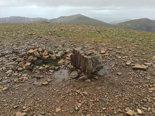 [/img]
Work out separately from B.A.Nana but the same answer, I think it's from the field you can see [url= https://www.google.co.uk/maps/ @54.4394639,-3.0539213,3a,37.2y,238.87h,79.4t/data=!3m6!1e1!3m4!1sL-kH7ZrF00Or2v55XCMp2w!2e0!7i13312!8i6656]here[/url]
Hmmm Is that up Whiteless Pike way? 😀
Hmmm Is that up Whiteless Pike way?
Close...
as ever he was mightily impressed 🙂
thanks
Crag Hill 🙂
pah! hes upped the ante again. says location should be too easy so he wants the room number again!
unbelievably you sorted me out before which astonished him, so im hoping you may be able to come up trumps again 😀
[img]  ?oh=d655d8cdf1181f3ef0e86037360a4652&oe=58C6E67B[/img]
Easy, bunkhouse barn at bortherswater campsite
edit too close to road so it's in the pub brotherswater inn at the campsite (sykeside I think it's called)
thanks, thats a start. now er...... what number room? 🙂
top window
[img] 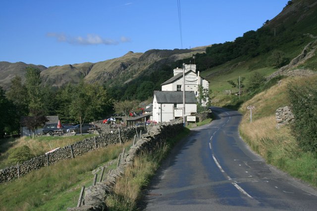 [/img]
aye, ive been googling pics and seen a pic almost the same as my mates, so ive sent an email request to them asking which room number it is. if i have no joy ill ask about that top window, itd be nice to give him a number to mess with his head 😉
if i have to ring to ask about that room, what does it overlook? top room looking up at what?
thanks a lot mate
stoney cove and middle dodd, or looking up towards kirkstone pass
is that the bunkhouse in front of the window?
No bunkhouse is down to the left of the pic on the campsite (probably not even in that pic). That's maybe more B&B accomm or staff accomm.
Edit yeah bunkhouse is way out of pic down a hill
thanks mate. just rang em and tried describing it and theyve told me they think its room 5. ill let you know if thats right.
thanks a lot 🙂
yep, was room 5. hes now convinced i can do voodoo 🙂
next one....
[img]  ?oh=a80b8715b23fc64b8429b299b2ebfa9b&oe=58F608D7[/img]
and
[img]  ?oh=55039b66c4f664e93d48047d69269eb9&oe=58B77924[/img]
for some context, ill include some of his other pics from same weekend so you can see what area hes been in. dont need to guess these, only the top two thanks 🙂
[img]  ?oh=af97f85487a106b76e9bd20d18fdca62&oe=58F36ED8[/img]
[img]  ?oh=e62347311a14512f06e1f68ed19ae802&oe=58EE1457[/img]
[img]  ?oh=a00ccf830148be1d4caf08df53d79b2a&oe=58B29F90[/img]
[img]  ?oh=d735259bd7f51893d2da4df8d16ef3ca&oe=58F5BB6C[/img]
[img]  ?oh=0f9696d3598a9db15730513b07c96ad8&oe=58BAC1AB[/img]
[img]  ?oh=8c2362757e246c671e8bd68d149f2350&oe=58EFDF50[/img]
theres no saying that room 9 was where he actually stayed, dont know where it is or how many rooms it has.
thanks
[img]  [/img] ❓
That's the bunkhouse at Sykeside Campsite / Brotherswater Inn 😀
This is the Building from the other side (shop, shower block, drying room), your mate's van would be parked behind
[img]  [/img]
great stuff thanks. what about the top pic, davidtaylforth looks like hes got it, where is it?
good work chaps 🙂
davidTs is from sour howes
It's Windermere lake BTW!
next!
[img]  ?oh=8bc457b8fd5f239e70816d61997440aa&oe=5907EAD5[/img]
Langdale pikes from tarn hows (haven't been up there for 20years so could be mistaken)
Its Blea Tarn
Had my suspicions I was wrong. Ironically I was scanning some old of my old slides a while back and I've got an almost identical photo, couldn't remember where I took it.
thanks as ever chaps, spot on.
But where's the hip flask?
He's slipping. That was way too easy! It's on the opening credits to Countryfile...
If I was in his shoes, I wouldn't have wanted to go through the same scenario again.
he did actually apologise that it was missing in this photo 🙂
He's slipping. That was way too easy! It's on the opening credits to Countryfile...
i must be getting better at working out which ones are going to be tough to locate. soon as i saw this one i though you lads/lasses will get it pretty quick.
NEXT!
[img]  ?oh=b6605aa8e4bd6d4e8236a990d2aaf049&oe=59448D01[/img]
[img]  ?oh=3158eb8a244bf4f90b5842fd632c30cc&oe=59397444[/img]
That's about 100 feet back from the last one, with a bit of snow added.
I must admit, this one has me beaten. 🙁
It does look like it's from Blea Tarn again
I think you're right!! Hadn't twigged that.
Thanks 🙂
Blea tarn looking at the Langdales.
latest......
1. [img]  ?oh=e0abc4fb26b735d603ae4fbec0b4b389&oe=596BBABB[/img]
2. [img]  ?oh=36409b76e3b56c22c08bc8eeb09da69a&oe=596074C6[/img]
3. [img]  ?oh=5209a4dc0e8dee920cd37db804d3da55&oe=5995DC8F[/img]
the first one coud be anywhere but I reckon between Ambleside and Skelwith FOld
the second one is the Bronwen Nixon footbridge over the Rothay at Ambleside
third one is at Skelwith Fold
aaaaand some more....
1.
[img]  ?oh=7a80dccc10c24fae04603f17fd6c7ce0&oe=598AAA3A[/img]
2.
[img]  ?oh=6f23929e1f48dbd35a5483de5e9fa34e&oe=5952D6C3[/img]
3.
[img]  ?oh=1a4f2a094ddfd0a7ca68670d41683ac5&oe=59508FE3[/img]
4. hmmmmm.......hes after the room number again 😀
[img]  ?oh=ad366173afeba3b387eadfdcab298b00&oe=5991BE84[/img]
5.
[img]  ?oh=312bfcd4fa913523370b8bb7b3138284&oe=5980E49D[/img]
6.
[img]  ?oh=bab42efc3a388204f9c0da43b51c3ad9&oe=5995D0AB[/img]
plenty to go at there you clever peeps.....
bumpity bump
im not going away you know..... 😉
*cough* where are all my lakes experts????
These are a lot harder as there are no landscape features to recognise
you mean hes finally got me?? :'-(
hes badgering me, thinks hes got me so i took a look at some of the other pics in the album for clues. hes being sneaky!! looks like hes in the cotswolds!
heres another few pics to see if anyone recognises them but i cant expect any of my lakes experts to get em realistically so ill start another thread asking for cotswolds advice 😉
[img]  ?oh=0c3e9f4b64e23a34e67e34a73d9d30b1&oe=59893B12[/img]
[img]  ?oh=5028431fd88426e47a4497891f8f12ab&oe=597BA9AA[/img]
[img]  ?oh=73fa71e612db545cf297d7d79925e4b3&oe=5986275B[/img]
[img]  ?oh=be5264fa059e06086621c651a1c3ceac&oe=5981C5C3[/img]
The plaque behind the bronze firefighter statue is at Stratford upon Avon frie station. No help with the rest
Far more interesting when there's actually a cairn or a mountain/view in it 😳
The plaque behind the bronze firefighter statue is at Stratford upon Avon frie station. No help with the rest
youre right, nice one, my 'cotswolds thread' suggested maybe moreton in the marsh, but youre spot on its stratford. so........no 6 could also be that station and he maybe never went to moreton at all.
good work 🙂
rascal, i dont care whats in the pic, i just like astounding him with 'my' knowledge 🙂
At the risk of being a hotel room geek, he’s staying in either Stag Lodge or the White Hart in Stow-on-the-Wold. Not sure which room though, both next to each other.
Sorry, just seen the other thread. 😳
dont apologise mate, im keeping my eye on both threads 🙂
ive emailed both hotels asking them for room info, see if they come up with the goods 😉
back on track with the lakes, i believe hes been to borrowdale area. can you help with any of these photos please?
1. [img]  ?oh=e168de57ca0f55c0b90ccbbbdce12481&oe=59B4D968[/img]
2. [img]  ?oh=b17d7876eedce1d821b7bb54e927fa1e&oe=597AC6D0[/img]
3. [img]  ?oh=022a1c1554e169360dd63562d998fb31&oe=597A8ADE[/img]
4. [img]  [/img]
5. [img]  ?oh=a7ba6f2f0346d5dacbe4e9cdfc9d077e&oe=59874E77[/img]
thanks 🙂
1. Stonethwaite camp site ??
2. Bridge into Grange
3. Brandlehow Jetty
4. Millennium Stone, Derwen****er
5. Brandlehow Woods.
thats quick, thank you. how sure are you on the campsite?
80% ish...
boo, my first fail :-/ im told no 2 above is the bridge into seathwaite farm, not grange, its about 2 miles away apparently. ah well, cant win em all. hes given me another couple now, and looking at the full set of pics on facebook he may be in the same area? think this set are titled seathwaite farm too. anyone care to pinpoint them for me?
ta 🙂
[img]  ?oh=25e0dcc62a15be7ab1f77f2b96be3add&oe=59D9FC08[/img]
[img]  ?oh=d3a9a3f2707a5340764a1864716692c9&oe=59D290CB[/img]
bumpity bump.....
The first one is at Honister Slate Mine. The second one is at the top of the [url= http://streetmap.co.uk/map.srf?X=321766&Y=513695&A=Y&Z=115 ]old trackway[/url] above Honister
thank you very much 🙂
latest....... looking at his other pics it looks like he was round the great langdale area?
[img]  [/img]
[img]  [/img]
[img]  [/img]
[img]  [/img]
thanks 🙂
[img]  [/img]
Gibson Knott, it's on the ridge between Helm Crag and Calf Crag. Harrison Stickle is the prominent bump on the skyline.
Second one of the four is Calf Crag.
so do i understand it that 2 is different to 3? so no2 is calf crag and no 3 is gibson knott?
no idea with the others?
thanks 🙂
Yes. The first one is an indeterminate point on the ridge, I think it's around [url= http://streetmap.co.uk/map.srf?X=330732&Y=510404&A=Y&Z=120 ]here[/url]
Number 2 is Calf Crag
Number 3 is Gibson Knott
The drystone wall could be anywhere! But it's made from quarried slate rather than field stones.
The picture davidtaylforth posted is also Calf Crag.
The crag behind and right of the person in the first three shots is Deer Bield Crag, you can see fresh scree beneath the LH side which is the result of a huge rockfall in 1997 - it was effing huge, about 40 metres high, 20 metres wide and 10+ metres in depth.
High up on Whitburn path up Helvellyn - birk moor or something like that. Judging/guessing by the elevation., thought Seat Sandal at first but wrong angle I think
This is the [url= http://www.geograph.org.uk/photo/2135197 ]view from Birk Side[/url]
You can't see any of the Helvellyn/Fairfield range from the base of Deer Bield Crag so it can't be that far back. Here's another view from the summit of [url= http://www.geograph.org.uk/photo/448126 ]Calf Crag[/url]
I meant to say that Davidtaylforth's shot is from Gibson Knott not Calf Crag.
Thx I like that website
[img]  ?oh=fc810b6e23ad917d421c821c84108ba2&oe=5A33C461[/img]
between Langholm (Dumfries) and Whita Hill
http://www.geograph.org.uk/photo/5080381