Which is Stroud, Glos. We have 5 lovely 5 valleys which converge here and a wall piece would be nice to put up at home. I've seen some before, usually old prints, but never been able to source one. Ta
Frame an old OS Map? I know the antiques place on the market place in Ciren has a fella that sells boxes of old maps for next to nothing, there's bound to be someone in Stroud/Nailsworth doing similar.
The colours of the old ones are great, I've got a framed Peak District one from the 1960s
There are plenty of websites where you can get a huge wall map of your area: http://www.mapsinternational.co.uk/huge-large-maps.asp
Might be a bit expensive though.
[url= https://www.ordnancesurvey.co.uk/shop/catalog/product/view/_ignore_category/1/id/9/s/custom-made-maps/ ]https://www.ordnancesurvey.co.uk/shop/catalog/product/view/_ignore_category/1/id/9/s/custom-made-maps/[/url]
[url= http://en-gb.topographic-map.com/places/Stroud-784774/ ]map here[/url]
I love the OS custom maps, I have a foldy one for my main riding areas (with a picture of me being rad on the front, because I am a tart) but they also do unfolded ones for walls etc.
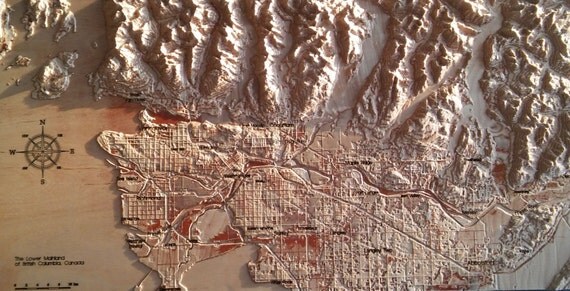
hmmm, kinda thinking like a 3D relief map, but can be 2D....
folded maps can be used - I have done so - Iron them then paste to the wall with wallpaper paste then multiple coats of clear varnish when dry
I have scotland in 1:250 000 on one wall, Europe at 1:3 200 000 on another and the world ( not mercator) at dunno the scale on another.
What about a reproduction of the William Smith 19th century geology map of Gloucestershire?
[url= http://shop.bgs.ac.uk/Bookshop/product.cfm?p_id=WSGL ]http://shop.bgs.ac.uk/Bookshop/product.cfm?p_id=WSGL[/url]
I'm aware of the OS one.
[img][url= https://c1.staticflickr.com/1/620/32970822946_f6820c5a88.jp g" target="_blank">https://c1.staticflickr.com/1/620/32970822946_f6820c5a88.jp g"/> [/img][/url][url= https://flic.kr/p/Sew5YA ]2017-02-20_01-02-05[/url] by [url= https://www.flickr.com/photos/martinddd/ ]martinddd[/url], on Flickr[/img]
😀
I've just bought 9 contiguous OS maps to paste onto a wall. I was going to avoid wallpaper paste though as I thought it would make them too wet and stretchy (making lining them up a problem). I thought white PVA glue would be better (and a matt varnish).
scotroutes - OS maps stretch along one edge only when pasted - so lining up is only an issue if you have some portrait and some landscape. I have no idea why this is so but I have done quite a few maps pasted to the wall. Butt the edges very tightly tho incase they shrink back a bit leaving a white line nd make sure the wall is a uniform colour underneath preferably white
Yeah, I'll be butting it in both directions. I could leave an overlap (in some cases this would be the edge grid) but the wall is magnolia so I don't think it'll need pre-painted.
I love my 3D lakes map, wish I could get more areas but no luck finding them so far....
wish I could get more areas but no luck finding them so far....
What, like [url= http://www.dorrigo.co.uk/product/index/RDALESUNF_Yorkshire_Dales_Raised_Relief_Map_Unframed_Mounted ]Yorkshire Dales[/url] or [url= http://www.dorrigo.co.uk/product/index/RPEAKUNF_Peak_District_Raised_Relief_Map_Unframed ]Peak District[/url]?
scotroutes - but so long as all the maps are in the same direction ie landscape then the stretch will match
While we are on the subject of maps, these are absolutely stunning and look superb framed:
http://espaceloisirs.ign.fr/boutique/carte-ancienne-aiguille-du-midi.html
http://espaceloisirs.ign.fr/boutique/carte-ancienne-aiguille-verte.html
Sorry Esme, shouldve said areas in Scotland. I'd love a 3D Arran map, or one of Glencoe....
We have 5 lovely 5 valleys
Except that climb up Old Neighbourhood
Salmon springs antique place on the A46 probably worth a look. If you find a more modern one please post as I'd love one too (Minchinhamptonite)
[quote=Nobeerinthefridge ]Sorry Esme, shouldve said areas in Scotland. I'd love a 3D Arran map, or one of Glencoe....
https://www.ordnancesurvey.co.uk/shop/dorrigo-3d-ben-nevis-glen-coe.html
Looks like they're from the same manufacturer (Dorrigo) as Esme's link. I've got the Peak District one and it's a little out of date - it doesn't feature the A6 bypass from Whaley Bridge to Chapel-en-le-Frith and that's been there for a few years
[url= http://www.cassinimaps.co.uk/shop/personalised.asp ]Cassini Maps[/url] sounds like what what you are looking for. They offer personalised versions of the various historical OS maps, and the 'Old Series' is the one that shows the topography with shading, albeit monochrome, as opposed to the contour lines now used in OS maps. You can see what they look like by entering a location on which the map is to be centred and clicking to see a sample image of that location.
They have resized the original maps to the same scale as Landranger 1:50,000, so you can get both old and new maps centred on the same location in the same scale, and display them side by side (which is what I have done).
Although Cassini offer framed and mounted maps, I would instead get the large format flat option, and get it framed myself.
These old Stroud maps from 1898 (in Scottish Map Archive) are rather nice and are probably free of copyright.
[url= http://maps.nls.uk/view/101168471 ]http://maps.nls.uk/view/101168471[/url]
The National Library of Scotland sell prints of old OS maps. I'm tempted to buy one, would look nice on the wall. http://maps.nls.uk/geo/find/
Great minds and all that !!

If you want something like this:
http://makezine.com/2016/01/06/laser-cut-topographical-map/
[img] 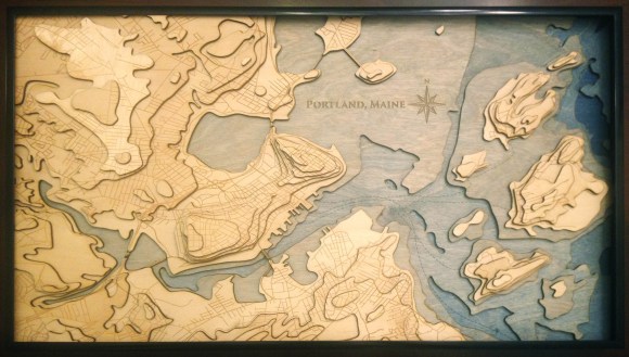 ?w=580[/img]
then email me (address in profile) I can make these.
Cheers all, Cassini maps looks promising.
